
TABLE OF CONTENTS
* Daily Celestials (Sun/Moon Data)
* Weekly Weather Nutshell
* Morning Discussion
* TIP: Scroll below for sections, or read all
~~~~~~~~~~~~~~~~~~~~~~
YOUR DAILY CELESTIALS
~~~~~~~~~~~~~~~~~~~~~~
STAR:
–OUR STAR WILL RISE AT: 7:18am this morning
–OUR STAR WILL SET AT: 4:34pm this evening
–TOTAL DAYLIGHT TIME: 9 hours and 16 minutes
MOON:
–OUR MOON WILL SET AT: 12:54pm this afternoon
–MOON SET DIRECTION: West-Southwest
–OUR MOON WILL RISE AT: 4:39am tomorrow morning
–MOON RISE DIRECTION: East-Southeast
–MOON PHASE: Waning Crescent (19.0%)
~~~~~~~~~~~~~~~~~~~~~~
>>> A NOTE FROM OUR SPONSOR <<<
Dave Hayes The Weather Nut is Sponsored by Individual Community Members, Patrons, and Gerard, Ghazey & Bates, P.C. GGBPC is a Northampton-based law firm regarded as the voice of pragmatic and well-reasoned estate planning, elder law and tax guidance in Western Massachusetts. The firm specializes in estate planning law, and expertly handles other matters such as Elder Law, Tax Law, as well as Real Estate purchase, sales, and refinance transactions. Contact GGBPC today to see how they can help!
~~~~~~~~~~~~~~~~~~~~~~
YOUR WEEKLY WEATHER NUTSHELL
~~~~~~~~~~~~~~~~~~~~~~
–Overcast today with periods of light snow showers this morning
–Upper low tracks east today, and develops more accumulating snow, mostly between 10am-4pm from west to east
–In general, another 2-5″ is expected, some areas only get another coating to an inch or so, some possibly over 5″ add’l, but 2-5″ is generally expected, it’ll be patchy
–Snow falls light to moderately today, briefly heavy for a few areas
–With additional snow on top of wet snow that has fallen along with northeast wind gusts up of 15-30mph we should seee additional isolated power outages possible
–Highs in the 20s to low 30s, lows in the teens tonight as snow quits around dinner time or so
–Monday is breezy, mostly sunny, highs upper 20s to mid 30s, lows in the teens
–An entirely different storm will rake the region after a cloudy Tuesday with highs in the mid 30s to low 30s
–Snow will arrive in the high terrain with a few inches possible before we turn to rain overnight most likely
–Rain may fall heavily at times into Wednesday with strong wind gusts of 30-50mph possible
–Additional outages and flooding possible with snow melt and new rain
–Another snow/rain stormo for Friday night into Saturday after a lull on Thursday
–I will start addressing these next storms in tonight’s report and certainly in tomorrow morning’s report, so stay tuned for updates on today’s storm, and those storms
~~~~~~~~~~~~~~~~~~~~~~
YOUR MORNING DISCUSSION
~~~~~~~~~~~~~~~~~~~~~~
Good morning everybody, I’m on 3 hours of “sleep” as I had to stay up and watch that band work through, and it was a glorious pasting!
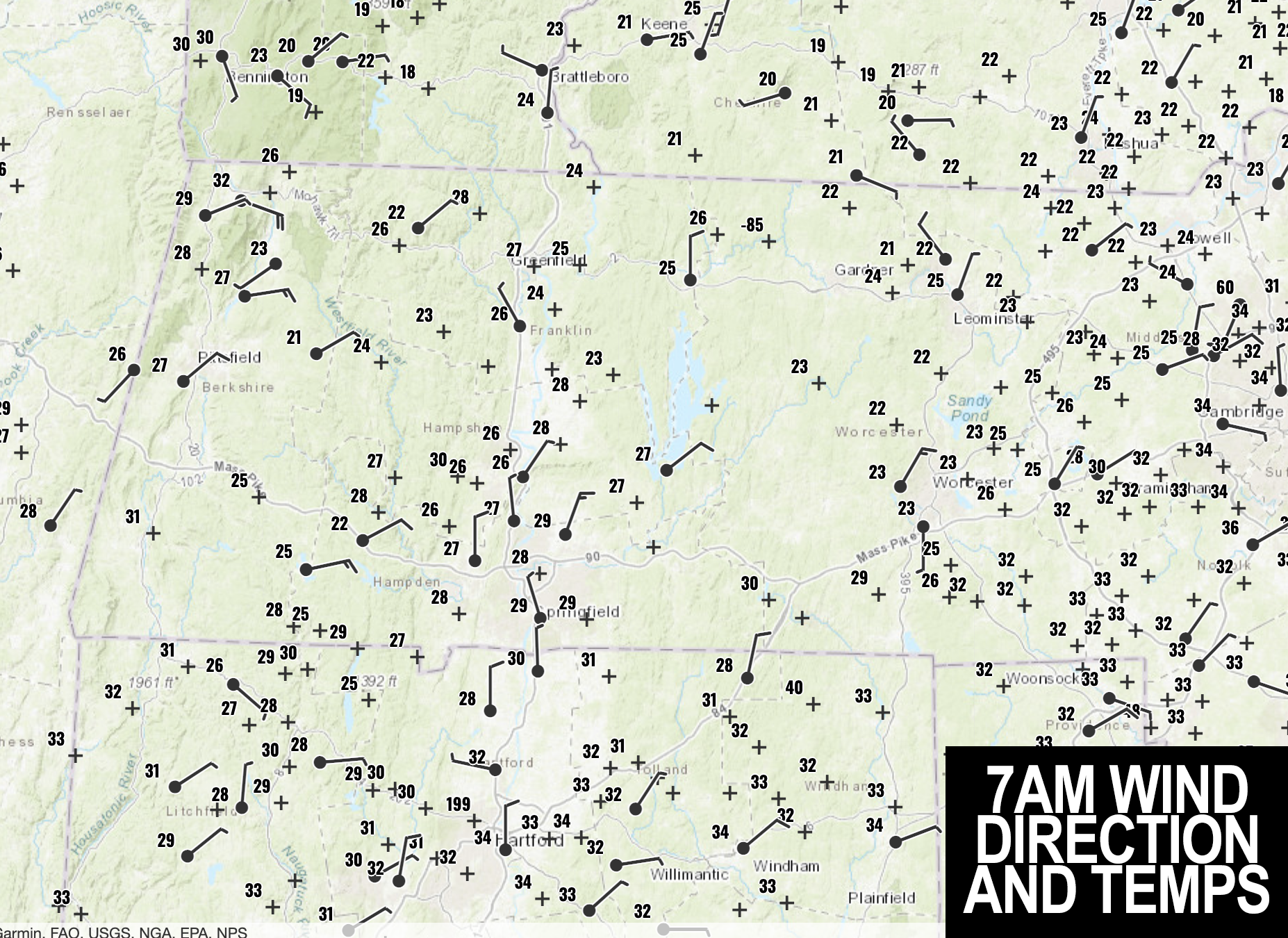
Areas of northern CT, the southern Berkshires, Hampden and Hampshire County into parts of southern Franklin County on over into CMass ended up in the heavier bands of snow overnight.
HEAVIER BANDS LOST STEAM NEAR RT. 2
As I had alluded to in either my late afternoon or early evening report last night, heaviest snow was looking to be relegated to mostly south of the Rt. 2 corridor, and based on reports from folks in ithe northern Berkshires and Franklin County, snowfall was significantly lighter up that way vs. a general 5-10″ in the central and southern valley and surrounding areas, with a foot in northwest CT where last night’s jackpot was for the greater WMass region.
Please let me know how much snow you got when you read this!
ROUND TWO
As for today, we have waves of snow showers tracking northeast into the region, and these will pick up in number and, at times, in intensity mostly between 10am-4pm from west to east.
This will be due to an upper level system now dropping moderate to heavy snow over central PA and NY tracking east through our region, and also strengthening the surface low that will deepen as it tracks to Nantucket this afternoon.
COLD AIR DRAIN = FLUFFIER
As the surface low deepens, and the upper low “captures” it, tracking east into our region, northerly flow at the surface will be invigorated and this will make temps COLDER as the day wears on, dropping many of us into the 20s.
This will tend to make the snow fluffier/drier with time, and could help enhance accumulations in some spots.
That’s the trickiness with accumulations is that a wetter snow doesn’t stack as easily as a drier snow, and when you’re getting mixes of both snow qualities, it’s tough to work it out, which is part of what goes into ranges provided.
FINAL AMOUNTS
I think my 6-12″ with a few spots over a foot (northwest CT could see over 15″!), and some areas more like 4-8″ will generally work out, though the Franklin county into the northwest Worcester County areas could also see that lower range by tonight which was not expected (and possibly the lowest part of that lower range of 4-8″).
SNOW INTENSITY
Snow may fall between half an inch an hour to as much as an inch an hour today, but again, intensity will be transient, intermittent and changeable given the weaker lift provided as the upper low drifts east through the region.
OUTAGES
Some additional isolated outages will also be possible with northeast to northerly gusts of 15-30mph interacting with wet snow-laden trees that see more snow added on top (we have about 2600 outages between Hampden and Worcester County as of this writing).
TWO MORE STORMS
Our storm will quit tonight as snow tapers off with lows down to either side of 20º. Monday morning will be a most wintry scene!
We’ll get a break in the action Monday with highs in the upper 20s to mid 30s under mostly sunny skies, and I would implore you to make sure your street drains are CLEAR of ice and snow leading up to the Tuesday night storm so RAIN can drain well (or at least more optimally). Lows Monday night drop into the teens.
For Tuesday, we cloud up, and then another potent storm will track west of us, but it will likely still be cold enough in parts of the Berkshires, western hilltowns and SVT to start as snow at night, and then mix with and change to rain which could become heavy at times.
Wind could also be a problem, but to be honest, I am not dialed in on this Tuesday/Wednesday storm OR the Friday/Saturday storm which is more snow to rain, most likely.
Just know that a couple more storm systems are on the way, and we will likely have to get through mid January to get back into a winter storm pattern, a these (and especially Tuesday night into Wed) will likely be “record-scratcher” storms, after our wintry end to the weekend and start to the upcoming work week.
Have a great day, and I will of course will be tracking this storm and incoming round 2 of snow showers and periods of snow all day long and will keep you updated.
Please post any reports below, thanks so much!
>>> BE KIND <<<
“Hello babies. Welcome to Earth. It’s hot in the summer and cold in the winter. It’s round and wet and crowded. On the outside, babies, you’ve got a hundred years here. There’s only one rule that I know of, babies: Goddamn it, you’ve got to be kind.”
–Kurt Vonnegut