
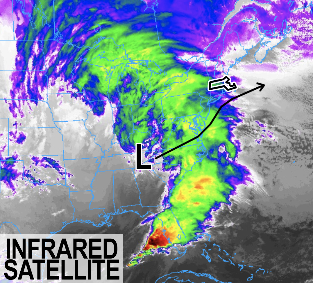
Infrared Satellite of Storm
TABLE OF CONTENTS
* Daily Celestials (Sun/Moon Data)
* Weekly Weather Nutshell
* Morning Discussion
* TIP: Scroll below for sections, or read all
~~~~~~~~~~~~~~~~~~~~~~
YOUR DAILY CELESTIALS
~~~~~~~~~~~~~~~~~~~~~~
STAR:
–OUR STAR WILL RISE AT: 7:18am this morning
–OUR STAR WILL SET AT: 4:33pm this evening
–TOTAL DAYLIGHT TIME: 9 hours and 15 minutes
MOON:
–OUR MOON WILL SET AT: 12:24pm this afternoon
–MOON SET DIRECTION: West-Southwest
–OUR MOON WILL RISE AT: 3:26am tomorrow morning
–MOON RISE DIRECTION: East-Southeast
–MOON PHASE: Waning Crescent (27.6%)
~~~~~~~~~~~~~~~~~~~~~~
>>> A NOTE FROM OUR SPONSOR <<<
Dave Hayes The Weather Nut is Sponsored by Individual Community Members, Patrons, and Gerard, Ghazey & Bates, P.C. GGBPC is a Northampton-based law firm regarded as the voice of pragmatic and well-reasoned estate planning, elder law and tax guidance in Western Massachusetts. The firm specializes in estate planning law, and expertly handles other matters such as Elder Law, Tax Law, as well as Real Estate purchase, sales, and refinance transactions. Contact GGBPC today to see how they can help!
~~~~~~~~~~~~~~~~~~~~~~
YOUR WEEKLY WEATHER NUTSHELL
~~~~~~~~~~~~~~~~~~~~~~
–Skies quickly become overcast this morning
–Temps in the 20s climb to the low to mid 30s
–First snow showers arrive between 4-7pm
–Snow becomes steady, and then moderate to heavy quickly between 8-11pm tonight
–Moderate to heavy snow falls around midnight toward dawn, before lulling out
–Snowfall rates of 1-2″ per hour are possible
–Travel is highly discouraged late tonight into early Sunday morning
–The bulk of accumulation falls overnight
–We enter a lull with periods of lighter snow or mixed precip south of the Pike into mid/late morning
–By late morning through the afternoon, the upper low tracks overhead, and helps produce more moderate accumulating snow before quitting by dinner time
–A general 6-12″ is expected across the greater WMass region
–Some areas should see over a foot, like high terrain areas in the western hilltowns, eastern Berkshires, southern Greens of VT and northern Worcester highlands, possibly up to 15″ or so
–A few areas in the southern parts of northern CT and westernmost Berkshire County up into the Bennington area more like 4-8″ due to downsloping
–Sunday night is freezing cold in the teens
–Monday is partly sunny, calm, wintry, highs low to mid 30s, seasonable
–Partly cloudy at night, lows in the upper teens
–Tuesday clouds over, and by night time snow develops in the high terrain with a few inches, before changing to rain everywhere
–Rain will fall heavily at times with southerly wind gusts over 40mph
–Wednesday morning rains with rising temps and a possible spike in wind gusts that may cause some isolated outages
–Flash flooding possible due to snowmelt and heavy rain
–Calmer end to late week with another mixed storm by Saturday
~~~~~~~~~~~~~~~~~~~~~~
YOUR MORNING DISCUSSION
~~~~~~~~~~~~~~~~~~~~~~
Good morning everybody, as far as our weather today is concerned, if you haven’t experienced it already, overcast skies will envelop your skyward-glancing eyes as the morning wears on, and temps will climb from the upper teens and 20s to the low to mid 30s, falling back into the upper 20s to low 30s tonight.
STORM UPDATE
Our storm will be tracking from eastern Tennessee northeast to near the DelMarVa Peninsula and Mid-Atlantic coastline, and then head northeast toward eastern Long Island overnight.
SNOW START
As this happens, initial snow showers will develop out ahead of the warm advection pattern, arriving into the greater WMass region between 4-7pm.
MODERATE TO HEAVY SNOW OVERNIGHT
Heavier snow bands will develop due to strong lift and be directed northward into southern New England after sunset, and I expect moderate to heavy snow to develop between 8-11pm from south to north in our region.
It should be ripping snow in many places by midnight, with 1-2″ per hour snowfall rates possible between 11pm and 5am (1″ per hour in the valley and lower elevations of MA and northern CT, with up to 2″ per hour in the western hilltowns, eastern Berkshires, southern Greens of VT and potentially the Worcester County high terrain into the eastern Franklin County hilltowns and parts of southwest NH).
TWO ACCUMULATION PERIODS
This will be the first of two periods of accumulating snow with this storm system.
After the warm advection snow burst moves through (when much of our accumulation will transpire) we should get a lull by very early Sunday morning, and also some mixing with ice/rain in parts of northern CT can’t be ruled out.
Periods of light snow will continue north of the Pike and light mix south are expected early to mid Sunday morning prior to the second period of accumulating snow, which has to do with the interaction between an incoming upper low and its interaction with (and likely strengthening of) our surface low which will be tracking east toward or south of Nantucket.
It appears for now that by later morning through the afternoon the snow shield should reinvigorate for 3-6 hours and produce periods of moderate to briefly heavy accumulating snow in the WMass/CMass region down into northern CT as cold air gets pulled into the low center, turning everybody back to snow by afternoon.
BUST POTENTIAL
However, it is this second period of anticipated snowfall that is the greatest area of uncertainty with this system.
I’ve seen many times when everything is pointing to the broad areas of lift that upper lows can bring with them as they track through an area, helping to develop what is called the “deformation zone” which is an area of slow-moving, sometimes even stationary heavier snow banding that forms within the northwestern flank of a nor’easter that puts down additional inches of accumulation before the storm quits.
I’ve also seen it fizzle into more showery, scattered, lighter snow areas that don’t really put much additional snow down, so I will be watching that tomorrow morning, and on guidance tonight and will convey my thinking on it to you in later reports.
AMOUNTS
Given all that, not much has changed from yesterday’s reports except that because I believe it’s more likely than not that we’ll see higher ends of the snow accumulation ranges offered due to this second period of snowfall tomorrow later morning into afternoon, I am going to bump them all up by about an inch or two across the board.
I think we see a general 6-12″ of snow accumulation in much of WMass, CMass, SVT, SWNH, and the northernmost towns in northern CT.
I think we’ll see more of a 4-8″ snowfall in the low terrain of western Berkshire County on up into southwest VT (Bennington), and that should also translate into the southern halves of much of northern CT due to mixing potential.
I also think some areas will likely exceed a foot of snow, and maybe up to 15″ or 16″ in parts of the western hilltowns, eastern Berkshires, the northern Worcester highlands, with foot-plus amounts possibly even scattered into eastern Franklin County and southwest NH as well.
But in general, 6-12″ should do it, lower half of that range for the Pioneer Valley floor, and more as you climb in elevation and/or gain latitude (go more north where it’s colder).
FLUFF OR PUFF?
The further north and west you go the fluffier the snow will be, and the furether south and east you go the more you’ll be huffing and puffing when you shovel the snow, so check its consistency, and take it easier if it is wetter.
WIND
As the storm approaches southerly wind will back out of the east, and overnight as the pressure gradient gets squeezed overhead, we’ll see easterly wind gusts of 20-35mph develop, with 30-35mph gusts mostly relegated to the high terrain.
The storm quits around dinner time, tapering to snow showers, and then drying out.
Highs Sunday will be in the upper 20s to low 30s with lows in the teens, and I can tell you that Monday morning is going to be most wintry!
I will also tell you to take pictures of our Monday wintry scene, because unfortunately it may substantially go away as an entirely different multi-hazard storm system is coming for Tuesday night into Wednesday with a front-end thump of snow for the high terrain, and then heavy rain, high wind, outages and flooding possible.
For our upcoming Monday, a pleasant, seasonably wintry day is in store with highs in the low to mid 30s under partly to mostly sunny skies as high pressure moves through. Lows will be in the teens.
SNOW, RAIN, WIND, FLOODING,
OUTAGE POTENTIAL TUE-WED
By Tuesday, I’ll be watching a powerful mid-latitude cyclone developing to our west over the southern Plains, but this storm will not have upper level steering currents favorable to track it east while keeping it to our south.
No, instead it will be guided northeast into the eastern Great Lakes during Tuesday.
This will spread clouds into our region, and highs will rise to the upper 30s to low 40s on southwesterly flow.
With some mid 30s present in the high terrain by late afternoon to early evening when precipitation arrives, the Berkshires, western hilltowns and southern Greens of VT could see a couple of inches of wet snow on the front end with a rain/snow mix in the valley before mild air overwhelms the column at all levels, changing everybody to rain, heavy at times overnight.
Southerly winds will also be gusting 25-40mph, and snow will begin to melt.
As heavy rain continues, flooding issues on streets and in some rivers may develop. As temps rise into the 40s Wednesday morning, we could see a spike of wind gusts over 50mph which could produce some isolated power outages.
Rain should quit by Wednesday afternoon, and cooler should work back in for the end of the work week with calmer conditions before ANOTHER storm could bring more mixed precipitation to the greater WMass region by next Friday night into Saturday.
Please stay tuned for updates on all three storms, but especially for our incoming snowy nor’easter, as I will update again before the storm commences this afternoon, and again tonight and throughout tomorrow, so keep it tuned here, and have a great day!
>>> BE KIND <<<
“Hello babies. Welcome to Earth. It’s hot in the summer and cold in the winter. It’s round and wet and crowded. On the outside, babies, you’ve got a hundred years here. There’s only one rule that I know of, babies: Goddamn it, you’ve got to be kind.”
–Kurt Vonnegut