
TABLE OF CONTENTS
* Daily Celestials (Sun/Moon Data)
* Weekly Weather Nutshell
* Morning Discussion
* TIP: Scroll below for sections, or read all
~~~~~~~~~~~~~~~~~~~~~~
YOUR DAILY CELESTIALS
~~~~~~~~~~~~~~~~~~~~~~
STAR:
–OUR STAR WILL RISE AT: 7:18am this morning
–OUR STAR WILL SET AT: 4:32pm this evening
–TOTAL DAYLIGHT TIME: 9 hours and 14 minutes
MOON:
–OUR MOON WILL SET AT: 12:00pm noon
–MOON SET DIRECTION: West-Southwest
–OUR MOON WILL RISE AT: 2:17am tomorrow morning
–MOON RISE DIRECTION: East-Southeast
–MOON PHASE: Waning Crescent (37.2%)
~~~~~~~~~~~~~~~~~~~~~~
A NOTE FROM OUR SPONSOR
~~~~~~~~~~~~~~~~~~~~~~
Dave Hayes The Weather Nut is Sponsored by Individual Community Members, Patrons, and Tandem Bagel Company… No matter the weather, Tandem Bagel is always there for you at several valley locations to make your mornings brighter! With bagels baked fresh daily (including Gluten-Free options), house-whipped cream cheese, coffee, and tons of lunch options, Tandem is the perfect quick stop for lunch, breakfast, or a coffee and bagel to go. Find them in Easthampton, Northampton, Hadley, Florence, and West Springfield, or use their super-streamlined online ordering tool by visiting their website.
~~~~~~~~~~~~~~~~~~~~~~
YOUR WEEKLY WEATHER NUTSHELL
~~~~~~~~~~~~~~~~~~~~~~
–Cold start today with temps in the teens to low 20s, some singles in SVT
–Wind chills in the single digits early will relent, as highs climb into the upper 20s to low 30s
–Mostly sunny today, wind relaxes by afternoon
–Cold tonight, teens to low 20s, high clouds build
–Clouds build becoming overcast Saturday, highs low to mid 30s
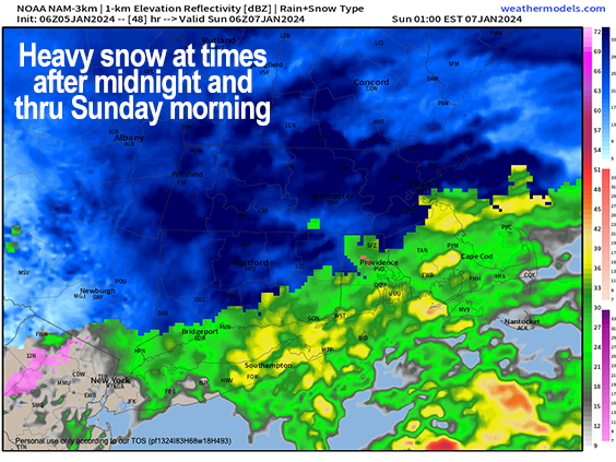
–Snow showers arrive 5-9pm south to north Saturday evening
–Snow becomes steady, then falls moderate to heavy overnight with rates over an inch per hour possible into Sunday morning, lows 20s
–Highs near freezing Sunday with snow in the morning, but mid morning through afternoon is uncertain
–We at least see periods of snow showers, but jury out re: steadier accumulating snow, except for perhaps northeast CT into southern CMass closer to storm, where highest totals more likely
–A general 5-10″ is expected, with 3-7″ over parts of SVT and SWNH, with a potential for 10-14″ in northeast CT up into CMass well south of the Rt. 2 corridor
–This storm could bust high if eveything aligns, and snow falls steadily and accumulates throughout Sunday
–If that happens, widespread 7-14″ could result
–Snow winds down Sunday night, cold
–Monday is sunny and in the 30s
–Tuesday clouds up with snow to rain by later afternoon
–Windswept rain looks likely Tuesday night into Wednesday with gusts up to 50mph
–Some street flooding and isolated outages possible
–Another storm is possible for the following weekend that may have some wintry mix with it
~~~~~~~~~~~~~~~~~~~~~~
YOUR MORNING DISCUSSION
~~~~~~~~~~~~~~~~~~~~~~
Good morning everybody, we’re starting off quite cold this morning with temps in the teens to low 20s, and even some single digits noted in southern VT!
In addition, we had a max gust overnight of 35mph at Pittsfield Airport, and had a recent gust of 30mph at Barnes Air Force Base in Westfield, which I have found tends to be one of the wind maxima spots in the Pioneer Valley floor.
This has produced wind chills in the single digits in a number of areas, so bundle up peeps!
Winds gusting out of the northwest *mostly* in the 10-20mph range this morning will slacken by afternoon, with highs in the upper 20s to mid 30s. Lows will drop to either side of 20º tonight as high clouds build in late.
SATURDAY AND SETUP
We will quickly become overcast tomorrow on Saturday, and highs should generally wind up in the low to mid 30s.
High pressure that brought us sunshine today will be south of us and east of the Mid-Atlantic and Carolina coastlines.
Meanwhile, our surface low will eject out of the Gulf of Mexico on Saturday and be guided northeast off of the DelMarVa Peninsula and positioned somewhere south of eastern Long Island, RI and southeast MA by Sunday morning.
As the storm pushes northeast to and off of the eastern seaboard, this will produce moist flow and lift off of the Atlantic Ocean, resulting in first snow showers arriving between 5-9pm, and quickly becoming steadier and heavier either side of midnight.
BUST POTENTIAL
I will provide my snow amounts below *but* any and every storm carries with it some amount of bust potential, which I suppose goes without saying.
This storm’s potential bust has to do with what happens after the first burst of moderate to heavy snow late Saturday night into Sunday morning, because that part of it seems very likely at this point.
In other words, late Saturday night and early Sunday morning travel is discouraged as the brunt of the snowfall hits, and crews work to keep on top of managing road conditions as best they can.
SUNDAY IS A BIT OF A WILD CARD
However, the interaction between the upper level low swinging in behind and to the west of the surface low, how much it slows it and strengthens it, along with where exactly a low level jet streak will provide additional lift and hence steadier accumulating snow later Sunday morning into the afternoon, will be the difference between more of a moderate snowfall of 5-10″ with possibly a bit less over parts of SVT or northern SWNH, and a more major snowfall with more of a 7-14″ result.
I think the best chance for a 10-14″ stripe is going to be closer to the storm, but far enough inland, which could be northeast CT into CMass south of the Rt. 2 corridor.
STEADY OR SHOWERY SUNDAY?
I’ve seen many times where after that first warm advection burst, if things don’t line up perfectly, the snow shield can become showery and patchy, and that could happen on Sunday from about mid-morning onward through the afternoon.
If that happens with marginal temps in the low 30s, we might not see much additional accumulation during the day Sunday, and instead get intermittent snow showers.
However, if the upper low slows the surface low, deepens it, and the lift becomes broader and steadier, we could see that higher set of snowfall totals I alluded to (a widespread 7-14″ across the whole region, again highest NE.CT and southern CMass).
AMOUNTS
I am leaning more towards 5-10″ for most of the greater WMass region (with a 3-7″ area in SVT and SWNH, and possibly even the northern third of Berkshire County), and at this point we can’t rule out a brief mix of rain in southern parts of Hartford and Tolland County CT, then back to snow Sunday as the storm tracks east.
WIND
We will also have an east wind to contend with, because as the storm gets closer it will drive gusts of 20-30mph into our region, though the high terrain tends to get the higher wind gusts in these setups, and the valley tends to be lighter. So if you live in the hills, it’ll be breezy, I think.
The storm winds down later Sunday afternoon after highs in the upper 20s to low 30s, with lows Sunday night on top of fresh snow cover in the upper teens.
Monday is the calm before the second storm with sunshine and highs in the mid to upper 30s and lows in the 20s.
By Tuesday, a potent storm will be cranking up to our west, and while we could start as snow, we will likely change to rain, and it could be windswept Tuesday night into Wednesday with southerly gusts of 30-50mph. Rain could fall heavily, and we can’t rule out some street flooding or isolated power outages.
Another storm looms for next weekend which may be more of a mixed precip event, so this has been your Jekyll-n-HydeCast for today! Have a great day and check back with me about our first widespread snowfall of this nascent winter season!
>>> BE KIND <<<
“Hello babies. Welcome to Earth. It’s hot in the summer and cold in the winter. It’s round and wet and crowded. On the outside, babies, you’ve got a hundred years here. There’s only one rule that I know of, babies: Goddamn it, you’ve got to be kind.”
–Kurt Vonnegut