
TABLE OF CONTENTS
* Daily Celestials (Sun/Moon Data)
* Weekly Weather Nutshell
* Morning Discussion
* TIP: Scroll below for sections, or read all
~~~~~~~~~~~~~~~~~~~~~~
YOUR DAILY CELESTIALS
~~~~~~~~~~~~~~~~~~~~~~
STAR:
–OUR STAR WILL RISE AT: 7:18am this morning
–OUR STAR WILL SET AT: 4:31pm this evening
–TOTAL DAYLIGHT TIME: 9 hours and 13 minutes
MOON:
–OUR MOON WILL SET AT: 11:40am this morning
–MOON SET DIRECTION: West
–OUR MOON WILL RISE AT: 1:11am tomorrow morning
–MOON RISE DIRECTION: East
–MOON PHASE: Waning Crescent (46.7%)
~~~~~~~~~~~~~~~~~~~~~~
A NOTE FROM OUR SPONSOR
~~~~~~~~~~~~~~~~~~~~~~
Dave Hayes The Weather Nut is Sponsored by Individual Community Members, Patrons, and Tandem Bagel Company… No matter the weather, Tandem Bagel is always there for you at several valley locations to make your mornings brighter! With bagels baked fresh daily (including Gluten-Free options), house-whipped cream cheese, coffee, and tons of lunch options, Tandem is the perfect quick stop for lunch, breakfast, or a coffee and bagel to go. Find them in Easthampton, Northampton, Hadley, Florence, and West Springfield, or use their super-streamlined online ordering tool by visiting their website: https://www.tandembagelco.com
~~~~~~~~~~~~~~~~~~~~~~
YOUR WEEKLY WEATHER NUTSHELL
~~~~~~~~~~~~~~~~~~~~~~
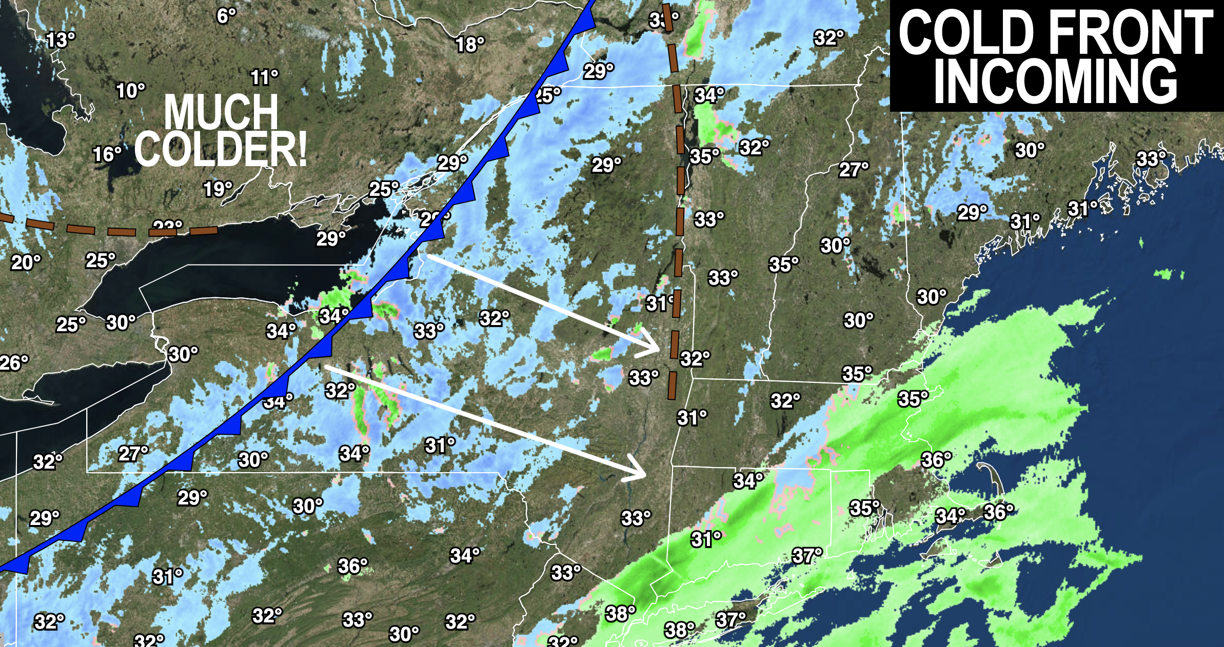
–Snow showers this morning taper off by afternoon, most of us remain dry, highs 35-40º
–Cold front moves through, northwest winds pick up by evening, gusting 15-30mph
–Lows in the teens, wind chills in the single digits by early Friday morning
–Sunny and cold Friday, highs mid 20s to low 30s, lows in the teens to near 20º
–Clouds build Saturday, highs low to mid 30s
–Snow arrives likely between 5-9pm after sunset
–After a few cold nights and days, travel likely becomes slippery and hazardous pretty quickly by either side of midnight
–Snow may fall 1″ per hour at times
–Moderate to heavy snow falls into Sunday morning, tapering off by afternoon at some point
–A widespread, plowable 4-8″ snowfall is expected, possibly a bit less in SVT and SWNH, but also could see some double digit totals, so stay tuned for updates
–Monday and Tuesday look calm and cool with highs in the 30s
–Tuesday night into Wednesday could feature a double barrel low pressure system due to secondary low forming
–If the 2ndary forms, could see accumulating front end snow thump Tuesday night, changing to ice and rain into Wednesday
~~~~~~~~~~~~~~~~~~~~~~
YOUR MORNING DISCUSSION
~~~~~~~~~~~~~~~~~~~~~~
Good morning everybody, while most of us will stay dry today, some will see scattered snow showers, most notably over northeast CT where coatings have formed (more related to our far-south storm system that missed its connection to the northern stream system).
A few more snow showers could move into the Berkshires and western hiilltowns up into SVT as the cold front pushes through by early afternoon, as well as just behind it in the colder northwest flow.
Highs today will crest into the 35-40º range before leveling off and falling back down later in the afternoon as colder advects into the region behind the front. Cloudy skies should lead to some sunny breaks, and maybe even a nice sunset.
Northwest winds will gust 15-30mph at times, which will help to prevent temps from completely being gutted by early morning, but still, lows will fall into the teens with wind chills in the single digits, so as Archie Bunker would say if he were one of the Friday morning meteorologists at one of the local TV stations, BUNDLE!
Friday becomes sunny with high pressure moving into the region, and cold with highs in the mid 20s to low 30s with lows in the teens to near 20º as high clouds build in late.
On Saturday, our storm system will be tracking northeast, lifting away from the Gulf of Mexico after picking up some juice, and heading for the Mid-Atlantic coastline, and ultimately tracking south of Long Island and Cape Cod into Sunday.
Our first weekend day will feature increasing cloudiness with highs in the low to mid 30s, with lower relative humidity.
Snow will be pushing into our region likely after sunset, sometime between 5-9pm the way it looks now, with temps dropping back into the upper 20s to low 30s before midnight and bottoming out in the mid to upper 20s overnight as snow falls, heavily at times, with rates of up to an inch per hour, making travel hazardous across the entire region, the way it looks now.
Snow willo continue to fall moderate to heavily into Sunday morning before it starts to taper off sometime in the afternoon.
AMOUNTS
There are still uncertainties that exist, but at this point it’s getting harder and harder to see how we don’t get a moderate-sized snowstorm Saturday evening into Sunday.
At this point, I believe a widespread 4-8″ is most likely with some scattered areas of 8-12″ amounts possible if everything comes together in terms of storm track, low pressure intensity, and banding to the northwest of the storm center to our south and southeast.
I could see perhaps 2-5″ in SVT and SWNH, esp. N halves of SVT/SWNH where drier air tries to work into the region.
Remember, remember, remember: please focus on the *entire* range and not just the highest number.
Beyond that, Monday and Tuesday look calm and cool, with another potent storm system that could bring more accumulating snow on its front end Tuesday night, changing to ice or rain with a wind component as well, so please stay tuned for updates!
>>> BE KIND <<<
“Hello babies. Welcome to Earth. It’s hot in the summer and cold in the winter. It’s round and wet and crowded. On the outside, babies, you’ve got a hundred years here. There’s only one rule that I know of, babies: Goddamn it, you’ve got to be kind.”
–Kurt Vonnegut