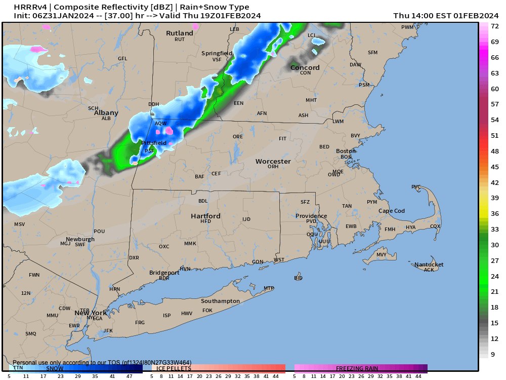
Cold front Thursday
TABLE OF CONTENTS
* Daily Celestials (Sun/Moon Data)
* Weekly Weather Nutshell
* Morning Discussion
* TIP: Scroll below for sections, or read all
~~~~~~~~~~~~~~~~~~~~~~
YOUR DAILY CELESTIALS
~~~~~~~~~~~~~~~~~~~~~~
STAR:
–OUR STAR ROSE AT: 7:04am this morning
–OUR STAR SETS AT: 5:03pm this evening
–TOTAL DAYLIGHT TIME: 9 hours and 59 minutes
MOON:
–OUR MOON RISES AT: 10:59pm tonight
–MOON RISE DIRECTION: East-Southeast
–OUR MOON SETS AT: 10:02am tomorrow morning
–MOON SET DIRECTION: West-Southwest
–MOON PHASE: Waning Gibbous (73.6%)
~~~~~~~~~~~~~~~~~~~~~~
A NOTE FROM OUR SPONSOR
~~~~~~~~~~~~~~~~~~~~~~
Dave Hayes The Weather Nut is Sponsored by Individual Community Members, Patrons, and Tandem Bagel Company… No matter the weather, Tandem Bagel is always there for you at several valley locations to make your mornings brighter! With bagels baked fresh daily (including Gluten-Free options), house-whipped cream cheese, coffee, and tons of lunch options, Tandem is the perfect quick stop for lunch, breakfast, or a coffee and bagel to go. Find them in Easthampton, Northampton, Hadley, Florence, and West Springfield, or use their super-streamlined online ordering tool by visiting their website.
~~~~~~~~~~~~~~~~~~~~~~
YOUR WEEKLY WEATHER NUTSHELL
~~~~~~~~~~~~~~~~~~~~~~
–A subsidence inversion continues, which locks in lower level moisture in the form of clouds, as well as patchy freezing drizzle/mist this morning
–Temps are in the 20s this morning, so anywhere you encounter misting, be alert for icy surfaces/travel, especially on secondary road ways
–Given the inversion and upper trough still over us this morning, we’ll have another mostly cloudy day with highs in ithe low to mid 30s
–We may see a few peeks of sunshine later today, but until tomorrow night’s cold front pushes this whole mid-level morass of trapped moisture out of here, gloomy vibes continue
–Lows tonight settle into the mid to upper 20s
–Thursday looks milder as southwest flow kicks up ahead of an incoming cold front
–We may see a few glimpses of sun Thursday morning, but again, it’s another mostly cloudy day with milder highs in the upper 30s to low 40s
–By afternoon and overnight some scattered rain or snow showers will move through, but should overall be of the #NoBigWhoop variety
–Lows drop to near 30º, and highs Friday will climb to either side of 40º with a few morning showers possible, and a few afternoon sunny periods expected
–High pressure finally crashes this party, and giant yellow-white orb that’s been illuminating our gloomy days and which brings life to this sector of the Universe will once again be revealed!
–This cell will build in from the north, so it looks like 30s for highs and teens for lows for days, hopefully Saturday through Tuesday with plenty of sunshine… here’s hoping!
~~~~~~~~~~~~~~~~~~~~~~
YOUR MORNING DISCUSSION
~~~~~~~~~~~~~~~~~~~~~~
Good morning everybody, our active storm pattern has finally relented, but our temperature inversion that has locked in the clouds and flurries and (now as of this morning) patchy freezing drizzle continues for another couple of days before we flip the atmospheric script and get some legit sunshine to spray our beloved hills and dales.
The dividing line that leads us from this post-stormy gloomy cloudy drizzly flurry period into our much-needed sunny pretty period moves through tomorrow afternoon and night in the form of a cold front, draped off an Alberta Clipper system that will bring snow to “The County”, a/k/a Aroostook County in northernmost Maine.
For us here in the greater WMass region, we’re starting this morning off with more clouds and patchy freezing drizzle due to trapped low level moisture combining with temps in the 20s this morning.
***Please be careful and aware of your surfaces when traveling early this morning, as I’ve heard of DOT crews out treating roads in northern CT.***
After this mist relents, we’ll be… mostly cloudy. Highs get up into the mid 30s, with a few sunny breaks possible late. Lows drop to the mid 20s or so.
Thursday, hopefully, is our last mostly cloudy day. After morning sunny breaks, we thicken the clouds again, and that dividing line I referred to above approaches by afternoon with some rain and snow showers as the cold front approaches.
Highs will reach to either side of 40º, and scattered mixed showers are possible in the evening as well.
By Friday, our cold front is swinging to the east and away from us as high pressure builds in from the northwest which should help to produce at least a partly sunny Friday afternoon with highs near 40º, then falling back into the upper teens at night.
After that, my friends, the best shot for an extended partly to mostly sunny stretch of days shows up on Saturday as we finally clear this cloudy gloom dome outta here!
Light winds, mostly sunny skies, dry weather, and highs in the low to mid 30s with lows in the upper teens looks to dominate for the Saturday through Tuesday period.
Truly, there is light at the end of the tunnel! Have a great day!
>>> BE KIND <<<
“Hello babies. Welcome to Earth. It’s hot in the summer and cold in the winter. It’s round and wet and crowded. On the outside, babies, you’ve got a hundred years here. There’s only one rule that I know of, babies: Goddamn it, you’ve got to be kind.”
–Kurt Vonnegut
