
POST TABLE OF CONTENTS:
–Weekly Nutshell (Quick impact list)
–Sponsor Note (Tandem Bagel Co.)
–NWS Alerts (Advisories, Warnings, Watches)
–Celestial Data (Sun/Moon info)
–Regional Summaries (quick in and out details)
–Morning Discussion (Longer-form explanation)
~~~~~~~~~~~~~~~~~~~~~~
DAVE’S WEEKLY WEATHER NUTSHELL
–Morning snow showers go bye bye
–Colder weather settles in today through Thursday
–Northwest winds gust 15-25mph today, chilly
–Partial to full sunshine today through Saturday
–Arctic blast arrives Friday, with below zero temps at night
–Wind chills may drop as much as 30 below zero Sat. morning
–Temps rebound quickly as this is not a pattern change
–Back to seasonable to slightly above seasonable into early next week with a few mixed showers possible, but before we jump into the weather discussion/details below, let’s check a note from our local and delicious sponsor, #TandemBagelCo, with their newest location in West Springfield, MA.
~~~~~~~~~~~~~~~~~~~~~~
A NOTE FROM OUR SPONSOR:
DHTWN Is Sponsored by Members, Patrons & Tandem Bagel Company: No matter the weather, Tandem Bagel is always there for you at several valley locations to make your mornings brighter! With bagels baked fresh daily (including Gluten-Free options), house-whipped cream cheese, coffee, and tons of lunch options, Tandem is the perfect quick stop for lunch, breakfast, or a coffee and bagel to go. Find them in Easthampton, Northampton, Hadley, Florence, and West Springfield, or use their super-streamlined online ordering tool by visiting their website.
~~~~~~~~~~~~~~~~~~~~~~~~~~~~~~~~
***DHTWN DAILY WEATHER REPORT***
~~~~~~~~~~~~~~~~~~~~~~~~~~~~~~~~
NATIONAL WEATHER SERVICE ALERTS
–None
DHTWN REMINDER
–The odds of being a human are 1 in 400,000 billion… do or share something you love today, even in a small way (see Kurt Vonnegut quote at end of post)
DAILY CELESTIAL (STAR):
–OUR STAR ROSE AT: 7:04am this morning
–OUR STAR WILL SET AT: 5:03pm this evening
–TOTAL DAYLIGHT TIME: 9 hours and 59 minutes
NIGHTLY CELESTIAL (MOON):
–OUR MOON WILL RISE AT: 12:25pm this morning
–OUR MOON WILL SET AT: 4:29am tomorrow morning
–MOON RISE DIRECTION: Northeast
–MOON SET DIRECTION: Northwest
–MOON PHASE: Waxing Gibbous (76.8%)
~~~~~~~~~~~~~~~~~~~~~~~~~~~~~~~~
DAILY TERRESTRIAL (ZoneCast)
ZONE 1 (Northern Region)
Southern VT, Southwest NH, N. Taconics NY
–High Temps: Mid to Upper 20s
–Low Temps: Mid to Upper Singles
–Wind: Northwest gusts 15-25mph
–Skies: Mostly cloudy with some partial sunshine later
–Precipitation: None
ZONE 2 (Central Region)
WMass, N. CMass, N. Litchfield County, C./S. Taconics NY
–High Temps: Upper 20s to Mid 30s
–Low Temps: Low to Mid 10s
–Wind: Northwest gusts 15-25mph
–Skies: Partly sunny
–Precipitation: Early morning snow showers along/south of the Pike, then dry
ZONE 3 (Southern Region)
S. CMass, S. Litchfield County, NC.CT, & NE.CT
–High Temps: Low to Mid 30s
–Low Temps: Upper Teens to Low 20s
–Wind: Northwest gusts 15-25mph
–Skies: Partly to Mostly Sunny
–Precipitation: Morning Snow showers, some coatings, then drying by mid to late morning
~~~~~~~~~~~~~~~~~~~~~~~~~~~~~~~~
WHERE’S DAVE?
1. I’ve been reporting our weather daily here and at https://www.westernmassweather.com for a decade
2. Get my free weekly newsletter here: https://westernmassweather.com/homepage/dhtwn-nutletter-signup/
3. Actively visit this FB page via the app or web, as I may not always auto-kiss your screens
~~~~~~~~~~~~~~~~~~~~~~~~~~~~~~~~
MORNING DISCUSSION
Good morning folks, our cold front is through the region and left over snow showers and mixed showers are pushing through areas mainly along and south of the MassPike this morning with coatings having been reported.
Let me know if you got any accumulation, please?
Otherwise, by mid-morning any snow showers will be out of the southern MA / northern CT part of our greater WMass region, and clouds will decrease from north to south with partly sunny skies increasing along with northwest winds gusting up to 25mph with highs in the mid 20s to low 30s.
For tonight, lows will drop into the low to mid 10s as northwest winds slacken with high pressure beginning to approach from the southwest late.
This feature will suppress any mid-week storminess south and out to sea. Some increased cloudiness may move through before said high pressure begins to really press in for Wednesday and Thursday.
Mostly sunny skies are expected for Wednesday into Thursday as of this writing, with highs 25-30º Wednesday and lows in the teens, followed by highs in the low to mid 30s as high pressure slips south of us for Thursday.
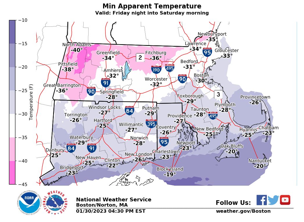
However, a major Arctic blast is set to overspread southern New England beginning late Thursday night which will drop temps into the upper singles to low 10s as northwest winds gust to 30mph behind the cold front.
Then on Friday into Friday night and early Saturday night, northwest winds should increase and could gust up to 40mph while a piece of the Arctic swings through the region and turns it into Hoth for a day.
Highs Friday will reach the upper teens to near 20º with lows below zero Friday night and wind chills as much as 30 below zero with wind continuing.
Saturday will feature high temps in the single digits to maybe low 10s with slowly slackening wind, and lows won’t be much colder than that under sunny/clear skies.
Sunday is a quick rebound as the Arctic lifts out of the region, with highs in the 30s with increasing clouds and a few snow showers possible, with lows in the 20s. Temps will rise into the mid to upper 30s for Monday as we continue into a mostly storm-less pattern.
I hope you have a great day, and click below to learn about other ways we can stay connected, thanks for reading!
Let’s Stay Together (click for options).
Join my Free Weekly Nutletter (click to join).
Follow me on Twitter (click to follow).
AND REMEMBER…
“Hello babies. Welcome to Earth. It’s hot in the summer and cold in the winter. It’s round and wet and crowded. On the outside, babies, you’ve got a hundred years here. There’s only one rule that I know of, babies: Goddamn it, you’ve got to be kind.”
–Kurt Vonnegut