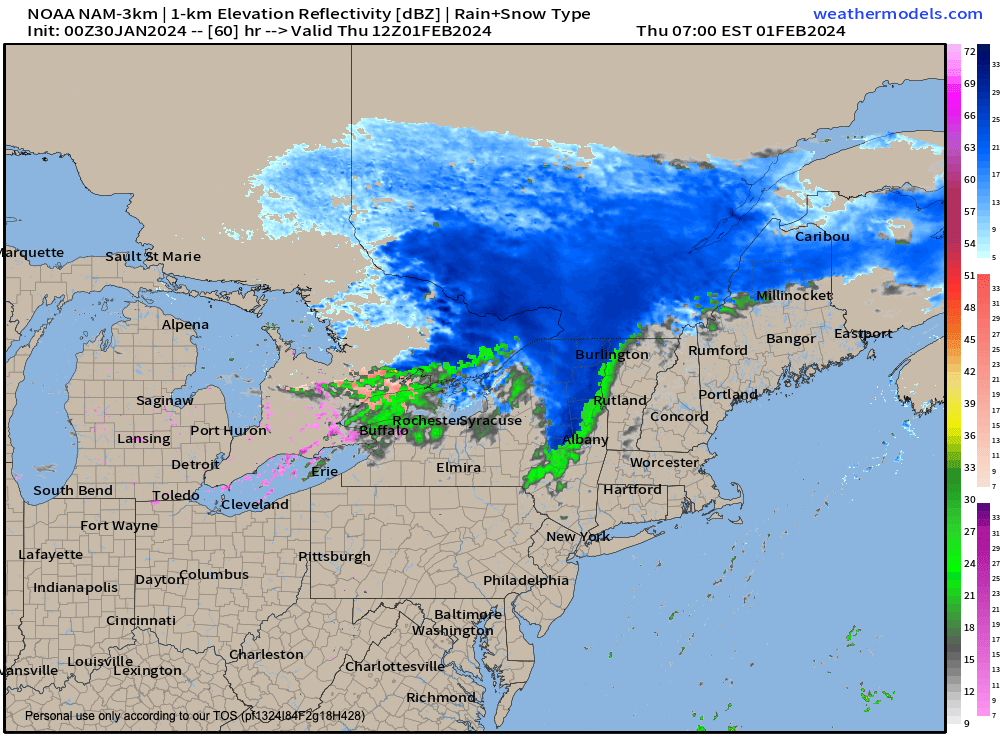
Cold front brings rain/snow showers Thu/Fri
TABLE OF CONTENTS
* Daily Celestials (Sun/Moon Data)
* Weekly Weather Nutshell
* Morning Discussion
* TIP: Scroll below for sections, or read all
~~~~~~~~~~~~~~~~~~~~~~
YOUR DAILY CELESTIALS
~~~~~~~~~~~~~~~~~~~~~~
STAR:
–OUR STAR ROSE AT: 7:05am this morning
–OUR STAR SETS AT: 5:01pm this evening
–TOTAL DAYLIGHT TIME: 9 hours and 56 minutes
MOON:
–OUR MOON RISES AT: 9:57pm this afternoon
–MOON RISE DIRECTION: East
–OUR MOON SETS AT: 9:43am tomorrow morning
–MOON SET DIRECTION: West
–MOON PHASE: Waning Gibbous (81.0%)
~~~~~~~~~~~~~~~~~~~~~~
A NOTE FROM OUR SPONSOR
~~~~~~~~~~~~~~~~~~~~~~
Dave Hayes The Weather Nut is Sponsored by Individual Community Members, Patrons, and Tandem Bagel Company… No matter the weather, Tandem Bagel is always there for you at several valley locations to make your mornings brighter! With bagels baked fresh daily (including Gluten-Free options), house-whipped cream cheese, coffee, and tons of lunch options, Tandem is the perfect quick stop for lunch, breakfast, or a coffee and bagel to go. Find them in Easthampton, Northampton, Hadley, Florence, and West Springfield, or use their super-streamlined online ordering tool by visiting their website.
~~~~~~~~~~~~~~~~~~~~~~
YOUR WEEKLY WEATHER NUTSHELL
~~~~~~~~~~~~~~~~~~~~~~
–Onshore flow brought half an inch of new unexpected snow to northern Tolland County CT and nearby areas last night in far southeast WMass and CMass
–Some snow showers and flurries are at it again in these same areas as onshore flow persists
–This produced clouds overnight that kept temps some 5-10º milder than forecast
–Therefore, more clouds than suyn today as onshore flow finally dissipates, but another shortwave moves into the region this afternoon (some sunny breaks expected)
–A few more snow showers possible this afternoon with the shortwave passage
–Highs upper 20s to mid 30s, lows low to mid 20s with some upper teens in SVT/SWNH if clouds clear enough
–Wednesday sees an upper ridge start to build in as flow turns out of the southwest, and temps are milder with highs in the mid to upper 30s with more clouds than sun (lows mid/upper 20s)
–On Thursday, a cold front approaches, draped off of an Alberta Clipper wave that will track into northern New England
–Clouds will thicken, and with highs in the mid 30s to low 40s, rain showers will move in during the later afternoon and at night, with some snow mixed into the high terrain
–Lows will drop to the upper 20s to low 30s
–By Friday afternoon into Monday (hopefully!!) it looks as of now like we’ll get high pressure building more directly into New England through the weekend
–This should produce partly to mostly sunny skies with highs generally in the upper 20s to mid 30s during this period
–No big storms in sight with seasonable to slightly above average temps into the second week of Feb
–Beyond that, signals are increasing that wer could turn colder and wintry by mid-month, lasting into March
–That’s a ways off, so just something I will be monitoring for now, but I do not believe winter is over, like some have said
~~~~~~~~~~~~~~~~~~~~~~
YOUR MORNING DISCUSSION
~~~~~~~~~~~~~~~~~~~~~~
Good morning everybody, I hope you slept well, I hope you have some pep in your step, or at least some oatmeal in your bowl, or maybe some eggs on your potato pancake!
The latter has been my go to recently: just shred half a big Russet, heat some olive oil in the pan, and drop/press that shred right into the skillet, flatten it out, salt it, flip it, put a coupla sunnysides on top and NOM NOM NOM NOM.
Simple food is some of the best food.
But I digress (and fantasize about my upcoming breakfast), on to the weather!
Last night I honestly was taking a breather, it’s been a long stretch and there’s been personal pulls on my life as well, but when I heard that Staffordville, CT got half an inch of snow at 8:30pm, I decided to modify Coach Belichick’s slogan: NO MINUTES OFF!
It’s amazing how the weather can change and redevelop on a dime, and last night’s more persistent onshore flow bloom (OFB) did just that, and snow showers persist in a northeast to southwest track this morning into easternmost Hampden County, northeast CT and CMass.
This also kept temps milder overnight due to more clouds around not allowing heat to radiate out to Space.
Some dustings are possible today, and more snow showers should be isolated to scattered in WMass this afternoon with a weak shortwave moving through with the departure of our upper low that FINALLY splits town by tomorrow. Buh bye!
With the onshore flow, the shortwave, weak ridging tomorrow and a cold front Thurs/Fri, it’s not going to be very sunny at all this week, I’m afraid, but some breaks will show I believe.
We have to wait until this weekend to get some real sunshine in here! It’s looking like a seasonably cold and very pleasant weekend ahead, so wee have that to look forward to.
More details are up in the Nutshell section… have a great day!
>>> BE KIND <<<
“Hello babies. Welcome to Earth. It’s hot in the summer and cold in the winter. It’s round and wet and crowded. On the outside, babies, you’ve got a hundred years here. There’s only one rule that I know of, babies: Goddamn it, you’ve got to be kind.”
–Kurt Vonnegut
