
POST TABLE OF CONTENTS:
–Weekly Nutshell (Quick impact list)
–Sponsor Note (Tandem Bagel Co.)
–NWS Alerts (Advisories, Warnings, Watches)
–Celestial Data (Sun/Moon info)
–Regional Summaries (quick in and out details)
–Morning Discussion (Longer-form explanation)
~~~~~~~~~~~~~~~~~~~~~~
DAVE’S WEEKLY WEATHER NUTSHELL
–Increasing clouds today ahead of a cold front with mild temps
–Rain and snow showers this evening and tonight, with some coatings to an inch or so far northern MA, SVT & SWNH
–Colder and fair weather dominates Tuesday through Thursday
–Hoth sets up shop in the region for Friday into Saturday as Arctic core swipes New England
–Wind chills may dip down to 30 BELOW zero Saturday morning
–We rebound Sunday, possible storm by early next week, but before we jump into the weather discussion/details below, let’s check a note from our local and delicious sponsor, #TandemBagelCo, with their newest location in West Springfield, MA.
~~~~~~~~~~~~~~~~~~~~~~
A NOTE FROM OUR SPONSOR:
DHTWN Is Sponsored by Members, Patrons & Tandem Bagel Company: No matter the weather, Tandem Bagel is always there for you at several valley locations to make your mornings brighter! With bagels baked fresh daily (including Gluten-Free options), house-whipped cream cheese, coffee, and tons of lunch options, Tandem is the perfect quick stop for lunch, breakfast, or a coffee and bagel to go. Find them in Easthampton, Northampton, Hadley, Florence, and West Springfield, or use their super-streamlined online ordering tool by visiting their website.
~~~~~~~~~~~~~~~~~~~~~~~~~~~~~~~~
***DHTWN DAILY WEATHER REPORT***
~~~~~~~~~~~~~~~~~~~~~~~~~~~~~~~~
NATIONAL WEATHER SERVICE ALERTS
–None
DHTWN REMINDER
–The odds of being a human are 1 in 400,000 billion… do or share something you love today, even in a small way (see Kurt Vonnegut quote at end of post)
DAILY CELESTIAL (STAR):
–OUR STAR ROSE AT: 7:05am this morning
–OUR STAR WILL SET AT: 5:02pm this evening
–TOTAL DAYLIGHT TIME: 9 hours and 57 minutes
NIGHTLY CELESTIAL (MOON):
–OUR MOON WILL RISE AT: 11:48am this morning
–OUR MOON WILL SET AT: 3:29am tomorrow morning
–MOON RISE DIRECTION: East-Northeast
–MOON SET DIRECTION: Northwest
–MOON PHASE: Waxing Gibbous (68.3%)
~~~~~~~~~~~~~~~~~~~~~~~~~~~~~~~~
DAILY TERRESTRIAL (ZoneCast)
ZONE 1 (Northern Region)
Southern VT, Southwest NH, N. Taconics NY
–High Temps: Mid to Upper 30s
–Low Temps: Mid Teens to Low 20s
–Wind: Light west to northwest then calm
–Skies: Some sunny breaks early with increasing clouds
–Precipitation: Dry during the day, snow or snow/rain mix showers after sunset with coatings to an inch of so possible
ZONE 2 (Central Region)
WMass, N. CMass, N. Litchfield County, C./S. Taconics NY
–High Temps: Upper 30s to Mid 40s
–Low Temps: Low to Mid 20s
–Wind: Light west to northwest then calm
–Skies: Some sunny breaks early with increasing clouds
–Precipitation: Dry during the day, snow or rain showers depending on elevation after sunset with coatings possible in far northwest and northern MA
ZONE 3 (Southern Region)
S. CMass, S. Litchfield County, NC.CT, & NE.CT
–High Temps: Mid to Upper 40s
–Low Temps: Mid to Upper 20s
–Wind: Light west to northwest then calm
–Skies: Some sunny breaks early with increasing clouds
–Precipitation: Dry during the day, scattered rain showers after sunset
~~~~~~~~~~~~~~~~~~~~~~~~~~~~~~~~
WHERE’S DAVE?
1. I’ve been reporting our weather daily here and at https://www.westernmassweather.com for a decade
2. Get my free weekly newsletter here: https://westernmassweather.com/homepage/dhtwn-nutletter-signup/
3. Actively visit this FB page via the app or web, as I may not always auto-kiss your screens
~~~~~~~~~~~~~~~~~~~~~~~~~~~~~~~~
MORNING DISCUSSION
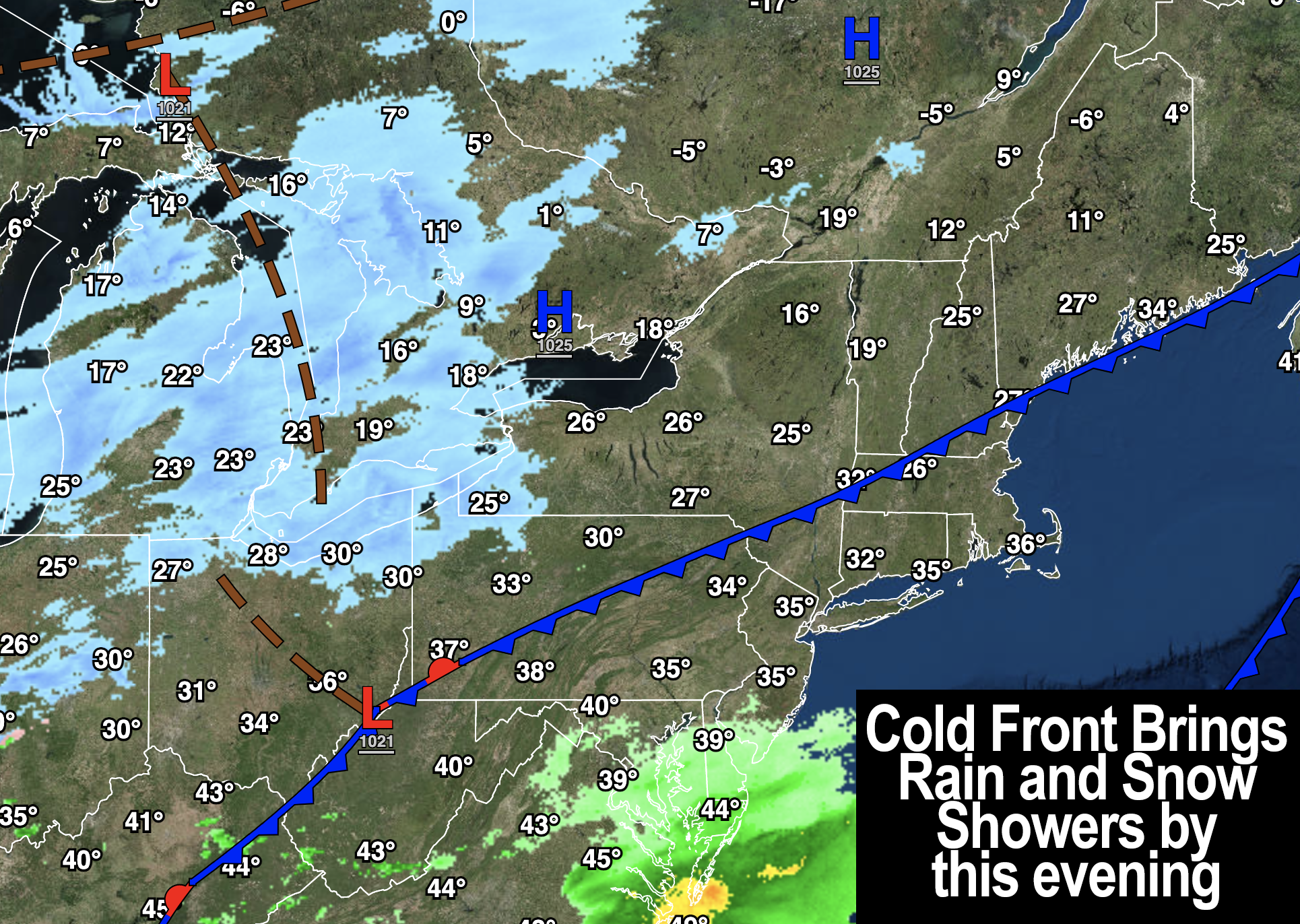
Good morning folks, we’ve got a not-super-strong cold front on the way through the region today, and in terms of precipitation, it’s likely the most exciting flurry of hydrometeors we’ll see over the next 7 days.
Sadly for snow lovers, it will be light and fleeting, but a few areas in far northern and northwest MA up into SVT and SWNH may see some coatings on the ground, and as much as an inch or two in the mountains and hills of SVT and SWNH.
Before that front arrives, however, we’ve got one more mild day on the way with temps mainly in the upper 30s to mid 40s with a few mid 30s in SVT and some upper 40s in northern CT. Any partly sunny skies will fill with clouds as the day wears on and winds will be light.
Once we get to around sunset or a bit thereafter, a period of rain and snow showers will move through the region with some coatings as mentioned, but most of us won’t see anything but air snow, and folks in the valley south and east probably will just see rain showers. All of this quits later tonight with lows in the 20s.
For Tuesday through Thursday, our new/colder air mass will suppress coastal low pressures south of our region, and out to sea.
This will leave us with fair weather through the week and WAY more sunshine is expected as well!
Tuesday and Wednesday will feature partly to mostly sunny skies with highs in the mid 20s to low 30s, and lows in the teens.
Tuesday’s new ushering of cold air into the region will come with northwest winds gusting 15-25mph, slackening into the mid-week period.
By Thursday, we’ll see temps come up well into the 30s with plenty of sunshine, but a very dry yet powerful Arctic front will sweep into the region at night, dropping low temps into the single digits.
The Arctic hammer drops Friday into Saturday, and I would strongly advise you to plan to protect any animals/pets, as well as pipes during this quick but brutal cold snap.
And while you’re at it, protect yourself, as northwest winds will gust 30-40mph Friday, Friday night into Saturday morning.
Highs will only be in the mid teens to low 20s Friday, and then lows will truly plummet below zero, with wind chills as much as 20 to 35 BELOW ZERO!
I am sure Wind Chill Advisories and Warnings will be hoisted by the NWS as we get closer to this event, as long as it trends the way it’s looking at this range.
Highs Saturday will only rise into the single digits to low 10s, with lows in the single digits, with plenty of sunshine during the day.
Sunday is a quick rebound as this Arctic snap has no staying power and lifts right back out of the region, with highs in the 30s for Sunday!
We may have some more storminess by early next week, but nothing is certain in that regard at the moment.
I hope you have a great day, and click below to learn about other ways we can stay connected, thanks for reading!
Let’s Stay Together (click for options).
Join my Free Weekly Nutletter (click to join).
Follow me on Twitter (click to follow).
AND REMEMBER…
“Hello babies. Welcome to Earth. It’s hot in the summer and cold in the winter. It’s round and wet and crowded. On the outside, babies, you’ve got a hundred years here. There’s only one rule that I know of, babies: Goddamn it, you’ve got to be kind.”
–Kurt Vonnegut