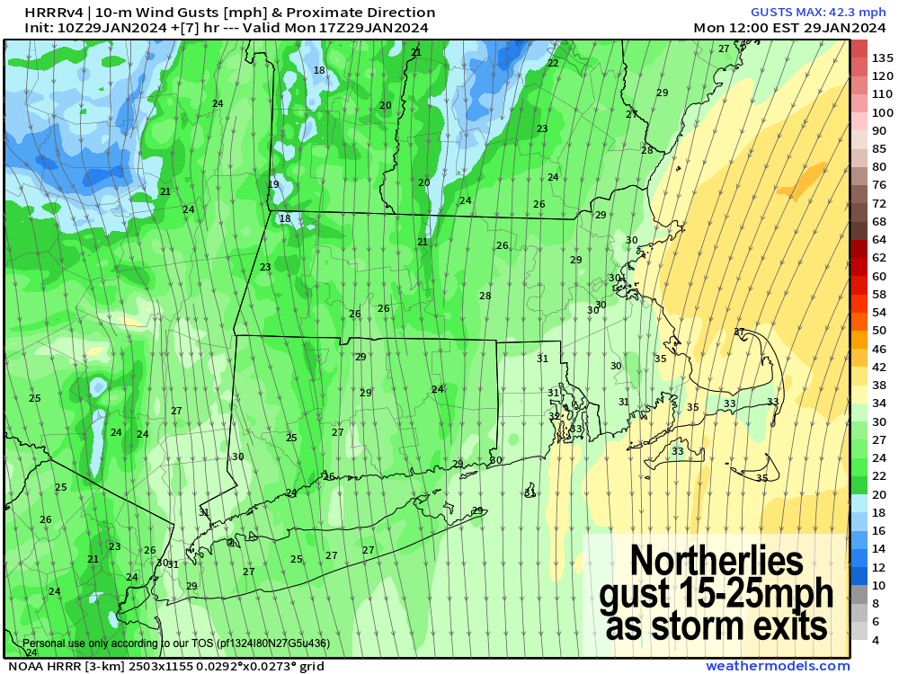
Breezy out of the north today
TABLE OF CONTENTS
* Daily Celestials (Sun/Moon Data)
* Weekly Weather Nutshell
* Morning Discussion
* TIP: Scroll below for sections, or read all
~~~~~~~~~~~~~~~~~~~~~~
YOUR DAILY CELESTIALS
~~~~~~~~~~~~~~~~~~~~~~
STAR:
–OUR STAR RISES AT: 7:06am this morning
–OUR STAR SETS AT: 5:00pm this evening
–TOTAL DAYLIGHT TIME: 9 hours and 54 minutes
MOON:
–OUR MOON RISES AT: 8:57pm this afternoon
–MOON RISE DIRECTION: East
–OUR MOON SETS AT: 9:25am tomorrow morning
–MOON SET DIRECTION: West
–MOON PHASE: Waning Gibbous (87.8%)
~~~~~~~~~~~~~~~~~~~~~~
A NOTE FROM OUR SPONSOR
~~~~~~~~~~~~~~~~~~~~~~
Dave Hayes The Weather Nut is Sponsored by Individual Community Members, Patrons, and Tandem Bagel Company… No matter the weather, Tandem Bagel is always there for you at several valley locations to make your mornings brighter! With bagels baked fresh daily (including Gluten-Free options), house-whipped cream cheese, coffee, and tons of lunch options, Tandem is the perfect quick stop for lunch, breakfast, or a coffee and bagel to go. Find them in Easthampton, Northampton, Hadley, Florence, and West Springfield, or use their super-streamlined online ordering tool by visiting their website.
~~~~~~~~~~~~~~~~~~~~~~
YOUR WEEKLY WEATHER NUTSHELL
~~~~~~~~~~~~~~~~~~~~~~
–Quiet weather arrives
–Final snow showers or flurries move through WMass region this early morning, gone by mid-morning
–Highs in the 30s today under mostly cloudy skies early, with a few sunny breaks possible by afternoon
–Northerly winds gust 15-25mph as the low pressure system pulls east and away
–Lows tonight will dip into the upper teens to low 20s
–Sunshine returns for Tuesday with highs either side of 30º, and lows in the upper teens
–High pressure tracks southeast of us, and puts us in a milder southwest flow mid to late week
–Partly sunny skies on Wednesday expected with highs in the mid to upper 30s, with lows in the 20s
–Clouds increase Thursday with highs 35-40º
–A cold front approaches Thursday night into Friday
–Highs again reach 35-40º on Friday, but then drop behind the front which should be accompanied by rain and snow showers
–Colder and sunnier this coming weekend with highs mid 20s to low 30s and lows in the teens as fair weather resumes heading into early next week
~~~~~~~~~~~~~~~~~~~~~~
YOUR MORNING DISCUSSION
~~~~~~~~~~~~~~~~~~~~~~
Good morning everybody, I sure picked a wacky region to try and cover weather-wise, as we saw a wide range in snow totals across my coverage area from a coating in many central/southern Pioneer Valley locations, on up to 8″ in the northern Berkshires, northwest hilltowns, and northern CMass, with amounts between those two regional mins/maxes.
Elevation dependent / marginal temperature winter storms are exceedingly difficult regarding accurate snow totals due to compaction, melting, snow intensity, snow duration, and temperature changes of just one or two degrees, all of which make huge differences in impacts.
As my friend Bill Dwight says, “The valley is where snowstorms come to die”, and that more often than not is true, given the inherent topographical impacts to weather systems, and our unique location in New England.
For more info, you can see read my Masslive article from late 2022 about this subject.
The only way the valley can get hammered in these marginal setups is a stronger secondary system that produces more dynamic cooling for longer, like we saw with our 2-3 hour morning burst yesterday. But, the ingredients just weren’t there to give the valley some snow love.
As I had alluded to yesterday, I was leaning toward lower end of ranges for the lower elevations, and I think that mostly played out. Let me know if I was mistaken, and let me know what you woke up to this morning for new snow on the ground where you live.
I will post a snow map later on from NWS once finalized, but have heard of coatings in Hampshire/Hampden valley floor towns, and 5″ in Shutesbury, 6″ in Plainfield, 8″ in Savoy, 4″ in northwest CT… how about you? Lemme know!
Going forward, we’re quiet, and this weather nut has a backlog of non-reporting tasks that need tasking, so I approve.
The Nutshell above mostly covers the details, but essentially we have our final flurries and snow showers moving through the region now, and they should be light to very light, and brief.
Mostly cloudy skies linger as the upper trough over us continues east and out to sea, with our surface storm long gone, and well east of Nantucket.
Highs reach the 30s today with northerly breezes, and colder air working tonight through Wednesday morning (lows near 20º).
A bit more sunshine arrives tomorrow with highs in the upper 20s to low 30s with lows in the upper teens.
High pressure tracks through and then southeast of us by mid week with highs in the 30s Wednesday (partly sunny skies), and 35-40º late week (cloudier) with lows in the 20s.
A cold front swings through into Friday with some rain and snow showers, and then we turn colder and sunnier this weekend with no big storms in sight.
Quietude awaits, and I’m sure for that just about all of us can breathe a sigh of relief.
Have a great day and thanks for all of the reports!
>>> BE KIND <<<
“Hello babies. Welcome to Earth. It’s hot in the summer and cold in the winter. It’s round and wet and crowded. On the outside, babies, you’ve got a hundred years here. There’s only one rule that I know of, babies: Goddamn it, you’ve got to be kind.”
–Kurt Vonnegut
