
Sunday night snow
TABLE OF CONTENTS
* Daily Celestials (Sun/Moon Data)
* Weekly Weather Nutshell
* Morning Discussion
* TIP: Scroll below for sections, or read all
~~~~~~~~~~~~~~~~~~~~~~
YOUR DAILY CELESTIALS
~~~~~~~~~~~~~~~~~~~~~~
STAR:
–OUR STAR WILL RISE AT: 7:08am this morning
–OUR STAR WILL SET AT: 4:58pm this evening
–TOTAL DAYLIGHT TIME: 9 hours and 50 minutes
MOON:
–OUR MOON WILL RISE AT: 6:54pm this evening
–MOON RISE DIRECTION: East-Northeast
–OUR MOON WILL SET AT: 8:49am tomorrow morning
–MOON SET DIRECTION: West-Northwest
–MOON PHASE: Waning Gibbous (97.1%)
~~~~~~~~~~~~~~~~~~~~~~
>>> A NOTE FROM OUR SPONSOR <<<
Dave Hayes The Weather Nut is Sponsored by Individual Community Members, Patrons, and Gerard, Ghazey & Bates, P.C. GGBPC is a Northampton-based law firm regarded as the voice of pragmatic and well-reasoned estate planning, elder law and tax guidance in Western Massachusetts. The firm specializes in estate planning law, and expertly handles other matters such as Elder Law, Tax Law, as well as Real Estate purchase, sales, and refinance transactions. Contact GGBPC today to see how they can help!
~~~~~~~~~~~~~~~~~~~~~~
YOUR WEEKLY WEATHER NUTSHELL
~~~~~~~~~~~~~~~~~~~~~~
–Any morning mist and fog dissipates by afternoon with drying and northwest flow
–Highs reach the mid 30s to low 40s, with a few peeks of sunshine at times
–Lows drop into the upper 20s to low 30s as clouds thicken
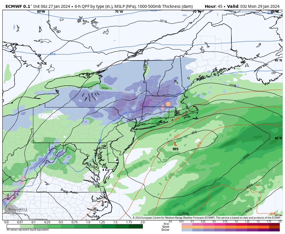
–Primary low pressure pushes northeast into southwest PA with its upper level component
–Secondary low pressure overnight begins to develop west of the DelMarVa Peninsula and then pushes offshore Sunday
–As this happens, precipitation pushes into the greater WMass region from south to north by early Sunday morning
–Precip is in the form of snow in the high elevations and rain or rain/snow mix in the central/lower CT River Valley of MA and CT, southern Housatonic River Valley in the southwest Berkshires, and much of northern CT
–Our storm tracks east-northeast toward a point south of Nantucket
–Snow and rain may mix with sleet during the day but by afternoon into very early evening, everybody should change to snow
–This storm has a pretty strong bust potential with it for areas along and south of the Pike in terms of getting lower amounts than I will propose
–Generally, I am sticking with 2-5″ in northern CT, central/eastern Hampshire and Hampden Counties, and southern CMass, with 4-8″ and up to 10″ of wet snow in the Berkshires, western hilltowns, Franklin County, northern CMass and SVT / SWNH
–Northeast winds gust 20-30mph Sunday night into Monday
–Snow winds down Monday morning to flurries, likely after the morning commute
–Fair weather with colder than average temps early week (20s to near freezing), increasing to seasonable or just above seasonable by end of the week (30s to near 40º)
~~~~~~~~~~~~~~~~~~~~~~
YOUR MORNING DISCUSSION
~~~~~~~~~~~~~~~~~~~~~~
Good morning everybody, we’ve got our pick of the weekend today with mostly cloudy skies which should brighten and reveal sunny breaks at times as a northwest drying flow sets up. Highs should reach into the mid 30s to low 40s for highs from north to south across the greater WMass region.
For tonight, the many aspects of our upcoming winter storm will begin to take shape and move into place over the surface of northeastern North America.
Clouds will thicken as our juicy southern stream system’s primary low center heads northeast into southeast Ohio adn southwest PA.
Lows will drop into the upper 20s to low 30s.
Dry air will be continuing to drain south, but our juicy storm will spread moisture north.
This could delay precipitation onset north of the Route 9 corridor in WMass/CMass as snow and rain showers move in south of a line from Pittsfield to Northampton/Amherst to Worcester (snow up high, rain or rain/snow mix down low).
Eventually, as our secondary low forms off of the DelMarVa and tracks east-northeast out over the open waters, moisture and milder air aloft will stream north, and we’ll get steadier snow and rain as we head toward and through mid-day.
Depending on how far north our secondary low center tracks, this will determine how far north the mild air aloft surges to keep rain or mixed precip (snow, sleet, rain) ongoing in the central and southern CT River Valley and points south and east in eastern Hampden County and northern CT.
Right now, it looks like our storm will pull east of our longitude either side of 6pm, which is when colder air will get pulled down and we start all changing to snow in the low levels, likely before midnight.
BUST POTENTIAL
At this point, it’s hard to see how anyone sees less than 2″ in these mix areas south and east, but if the precip shield develops in a weaker, more “ribbon-y” way due to a slower and less strong storm development, some of these areas could see more like 1-3″.
OUTAGES POSSIBLE
Inversely, the high terrain of the Berkshires, western hilltowns an northern Worcester County, bleeding weest into the hills of eastern Franklin County coulod get up to a foot of wet snow if this comes together, which would cause power outages in spots.
AMOUNTS
In general, I continue to go with 2-5″ of wet snow in central/eastern Hampshire and Hampden Counties, northern CT and southern CMass (along and south of the Pike), with 4-8″ in the Berkshires, western hilltowns, Franklin County, northern CMass, SVT and SWNH.
WIND AND DEPARTURE
Snow will fall overnight Sunday night into early Monday morning at rates of up to half an inch to an inch per hour, and then snow tapers off likely before noon. Winds will gust 20-30mph at times ouyt of the northeast, and for higher/colder regions, some blowing snow is possible.
I will post a more comprehensive update report by late this afternoon or early evening as I will be studying new data and observations through today, and will do my best to prepare you for tomorrow’s winter storm.
Have a great day!
>>> BE KIND <<<
“Hello babies. Welcome to Earth. It’s hot in the summer and cold in the winter. It’s round and wet and crowded. On the outside, babies, you’ve got a hundred years here. There’s only one rule that I know of, babies: Goddamn it, you’ve got to be kind.”
–Kurt Vonnegut