
WHAT YOU’LL GET WHEN YOU SCROLL
–Weekly Nutshell (Quick impact list)
–Sponsor Note (Tandem Bagel Co.)
–NWS Alerts (Advisories, Warnings, Watches)
–Celestial Data (Sun/Moon info)
–Morning Discussion (Longer-form explanation)
——————————-
DAVE’S WEEKLY WEATHER NUTSHELL
–Cold start to the day with calm to light wind
–Partly sunny on average (more cloudiness west, less east)
–Seasonable cold today, with a few flurries or snow showers possible in the afternoon
–Clipper low passes well north Saturday, a few more snow showers in northern MA, SVT and SWNH, scattered dustings possible
–Milder this weekend into Monday, with more rain or snow showers Sunday and Sunday evening depending on elevation
–We turn colder by Tuesday as Arctic air arrives on cross-polar flow, and then we watch for northern and southern stream disturbances to see if they hook up by mid week, but before we jump into the weather discussion/details below, let’s check a note from our local and delicious sponsor, #TandemBagelCo, with their newest location in West Springfield, MA.
——————–
A NOTE FROM OUR SPONSOR:
DHTWN Is Sponsored by Members, Patrons & Tandem Bagel Company: No matter the weather, Tandem Bagel is always there for you at several valley locations to make your mornings brighter! With bagels baked fresh daily (including Gluten-Free options), house-whipped cream cheese, coffee, and tons of lunch options, Tandem is the perfect quick stop for lunch, breakfast, or a coffee and bagel to go. Find them in Easthampton, Northampton, Hadley, Florence, and West Springfield, or use their super-streamlined online ordering tool by visiting their website.
——————————————-
***DHTWN DAILY WEATHER REPORT***
——————————————-
NATIONAL WEATHER SERVICE ALERTS
–None
DHTWN REMINDER
–The odds of being a human are 1 in 400,000 billion… do or share something you love today, even in a small way (see Kurt Vonnegut quote at end of post)
DAILY CELESTIAL (STAR):
–OUR STAR ROSE AT: 7:08am this morning
–OUR STAR WILL SET AT: 4:58pm this evening
–TOTAL DAYLIGHT TIME: 9 hours and 50 minutes
NIGHTLY CELESTIAL (MOON):
–OUR MOON WILL RISE AT: 10:28am this morning
–OUR MOON WILL SET AT: 12:08pm tomorrow morning
–MOON RISE DIRECTION: East-Northeast
–MOON SET DIRECTION: West-Northwest
–MOON PHASE: Waxing Crescent (38.1%)
———————-
DAILY TERRESTRIAL (ZoneCast)
ZONE 1 (Northern Region)
Southern VT, Southwest NH, N. Taconics NY
–High Temps: Low to Mid 30s
–Low Temps: Upper Teens to Low 20s
–Wind: Light southwest
–Skies: Mostly Cloudy (west) to Partly sunny (east)
–Precipitation: A few snow showers possible
ZONE 2 (Central Region)
WMass, N. CMass, N. Litchfield County, C./S. Taconics NY
–High Temps: Mid to Upper 30s
–Low Temps: Low to Mid 20s
–Wind: Light southwest
–Skies: Partly to mostly sunny
–Precipitation: A few snow showers possible
ZONE 3 (Southern Region)
S. CMass, S. Litchfield County, NC.CT, & NE.CT
–High Temps: Upper 30s to Low 40s
–Low Temps: Mid to Upper 20s
–Wind: Light southwest
–Skies: Partly to Mostly sunny
–Precipitation: A few snow showers possible
———————-
WHERE’S DAVE?
1. I’ve been reporting our weather daily here and at https://www.westernmassweather.com for a decade
2. Get my free weekly newsletter here: https://westernmassweather.com/homepage/dhtwn-nutletter-signup/
3. Actively visit this FB page via the app or web, as I may not always auto-kiss your screens
———————-
MORNING DISCUSSION
Good morning folks, the light is returning! We’ll reach 10 hours of sunlight by next week as we move into February, so that’s some good news!
We’ve also got tranquil weather for the most part to look forward to for now, for those that are sick of the slop storms (this writer raises his hand excitedly upwards like Arnold Horshack from Welcome Back, Kotter and shouts “OOOOOH! OOOOOH!”).
For today, light winds, partly sunny skies on average with more clouds northwest and a few snow showers or flurries in the afternoon, maybe mixed with rain in northern CT, highs 35-40º, seasonable, life continues.
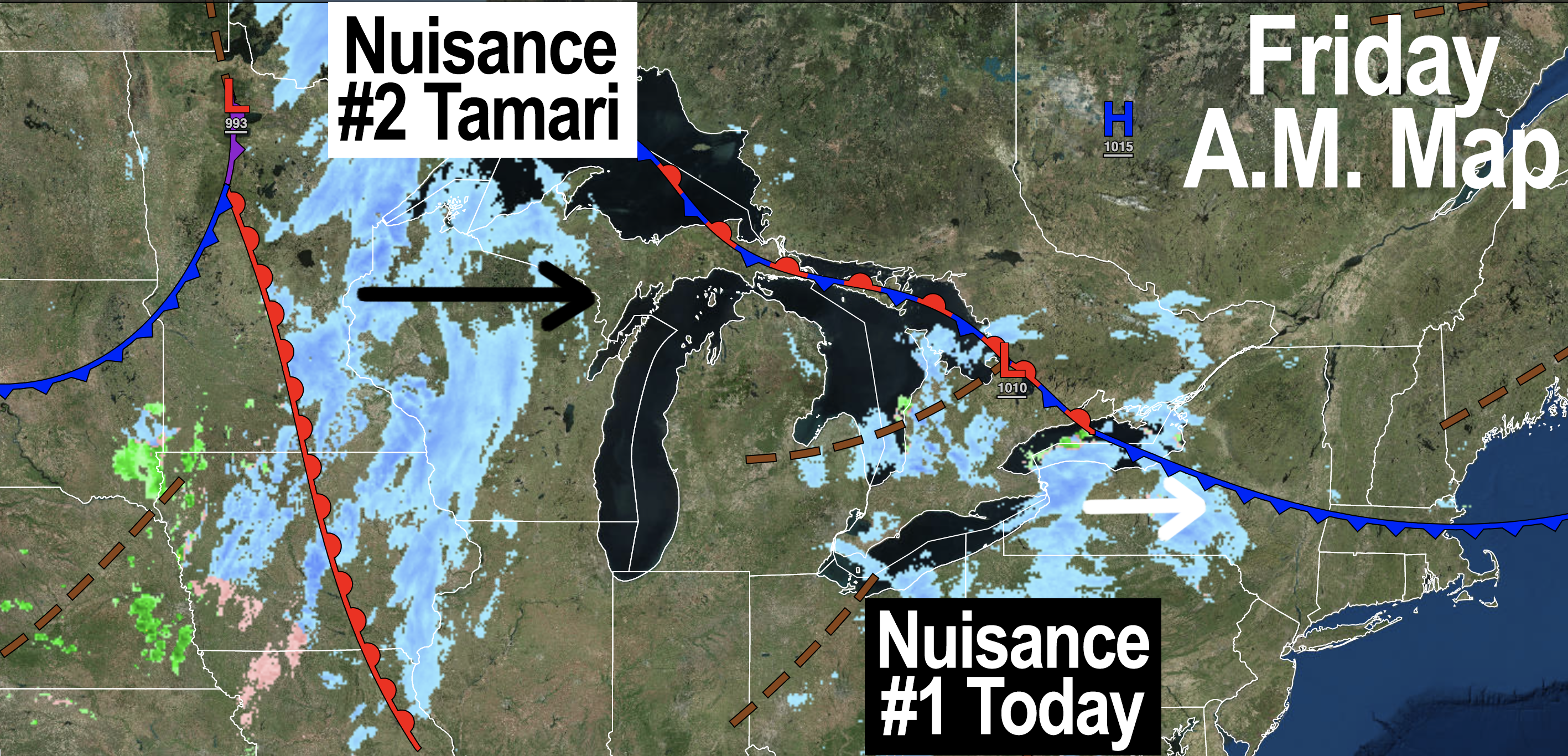
For tonight, we’re cold again with lows in the upper teens to mid to upper 20s from north to south with clouds increasing after midnight as a Clipper low tracks well north of us, moving west to east.
This will float some more snow showers into northwestern MA, southern VT and southwest NH in the morning, and a few coatings are possible before those abate toward afternoon.
Highs rise into the mid 30s to low 40s with lows in the mid 20s. We’re gonna make it after all.
#1970sTVQuoteDayApparently
Clouds continue for Sunday as does mild temps up into the upper 30s to mid 40s with more scattered rain or snow showers, depending on elevation, again not a big deal. Lows in the mid to upper 20s.
Monday is our last fairly mild day (35-40º for highs under partly sunny skies) before Arctic air arrives.
After lows in the low 20s, we will struggle to reach 30º on Tuesday as a winter chill overspreads the region.
We can expect highs in the 20s to low 30s through the rest of the week, and I’m still watching the mid-week period for a potential storm, but nothing looks overly promising at the moment.
Should that not materialize, we punt until next weekend when the next storm signal is showing up, and with cold air, we could see some impacts, so stay tuned, and have a great day!
Join my Free Weekly Nutletter.
AND REMEMBER…
“Hello babies. Welcome to Earth. It’s hot in the summer and cold in the winter. It’s round and wet and crowded. On the outside, babies, you’ve got a hundred years here. There’s only one rule that I know of, babies: Goddamn it, you’ve got to be kind.”
–Kurt Vonnegut