
WHAT YOU’LL GET WHEN YOU SCROLL
–Weekly Nutshell (Quick impact list)
–Sponsor Note (Tandem Bagel Co.)
–NWS Alerts (Advisories, Warnings, Watches)
–Celestial Data (Sun/Moon info)
–Morning Discussion (Longer-form explanation)
——————————-
DAVE’S WEEKLY WEATHER NUTSHELL
–Rain is ending this morning, and a cold front is coming through
–A few slick spots may remain in the high terrain of northern MA, SVT and SWNH, so be careful
–A few snow showers develop across SVT and far northwest MA later this morning, light accumulations possible
–West winds gust 25-40mph at times as colder air comes in, temps drop to the teens and 20s tonight
–Scattered snow showers are possible tonight, tomorrow, and early Saturday morning in far northwest MA and SVT
–Otherwise we have fair and seasonably cold conditions into early Sunday morning
–More mixed precipitation possible Sunday afternoon and night into very early Monday morning, doesn’t look like much
–Tuesday night into Wednesday may feature more wintry mix as Arctic air is beginning to press southeast into the region
–Very cold by late next week, but before we jump into the weather discussion/details below, let’s check a note from our local and delicious sponsor, #TandemBagelCo, with their newest location in West Springfield, MA.
——————–
A NOTE FROM OUR SPONSOR:
DHTWN Is Sponsored by Members, Patrons & Tandem Bagel Company: No matter the weather, Tandem Bagel is always there for you at several valley locations to make your mornings brighter! With bagels baked fresh daily (including Gluten-Free options), house-whipped cream cheese, coffee, and tons of lunch options, Tandem is the perfect quick stop for lunch, breakfast, or a coffee and bagel to go. Find them in Easthampton, Northampton, Hadley, Florence, and West Springfield, or use their super-streamlined online ordering tool by visiting their website.
——————————————-
***DHTWN DAILY WEATHER REPORT***
——————————————-
NATIONAL WEATHER SERVICE ALERTS
–Winter Storm Warnings continue for the high terrain of SVT
DHTWN REMINDER
–The odds of being a human are 1 in 400,000 billion… make it count, even in a small way (see Kurt Vonnegut quote at end of post)
DAILY CELESTIAL (STAR):
–OUR STAR ROSE AT: 7:09am this morning
–OUR STAR WILL SET AT: 4:57pm this evening
–TOTAL DAYLIGHT TIME: 9 hours and 48 minutes
NIGHTLY CELESTIAL (MOON):
–OUR MOON WILL SET AT: 10:59pm tonight
–OUR MOON WILL RISE AT: 10:28am tomorrow morning
–MOON SET DIRECTION: West
–MOON RISE DIRECTION: East
–MOON PHASE: Waxing Crescent (28.0%)
———————-
DAILY TERRESTRIAL (ZoneCast)
ZONE 1 (Northern Region)
Southern VT, Southwest NH, N. Taconics NY
–High Temps: Mid to Upper 30s
–Low Temps: Upper Teens to Low 20s
–Wind: West to southwest winds gust 25-40mph
–Skies: Mostly Cloudy
–Precipitation: Showers ending this early morning, with some snow showers in SVT later this morning into afternoon, coatings possible
ZONE 2 (Central Region)
WMass, N. CMass, N. Litchfield County, C./S. Taconics NY
–High Temps: Upper 30s to Low 40s
–Low Temps: Low to Mid 20s
–Wind: West to southwest winds gust 25-40mph
–Skies: Mostly Cloudy north/west to Partly Sunny south/east
–Precipitation: Some snow showers in far northwest MA, otherwise showers ending
ZONE 3 (Southern Region)
S. CMass, S. Litchfield County, NC.CT, & NE.CT
–High Temps: Upper 30s to Low 40s
–Low Temps: Low to Mid 20s
–Wind: West to southwest winds gust 25-40mph
–Skies: Mostly Cloudy west, Partly sunny east
–Precipitation: Showers ending, drying
———————-
WHERE’S DAVE?
1. I’ve been reporting our weather daily here and at https://www.westernmassweather.com for a decade
2. Get my free weekly newsletter here: https://westernmassweather.com/homepage/dhtwn-nutletter-signup/
3. Actively visit this FB page via the app or web, as I may not always auto-kiss your screens
———————-
MORNING DISCUSSION
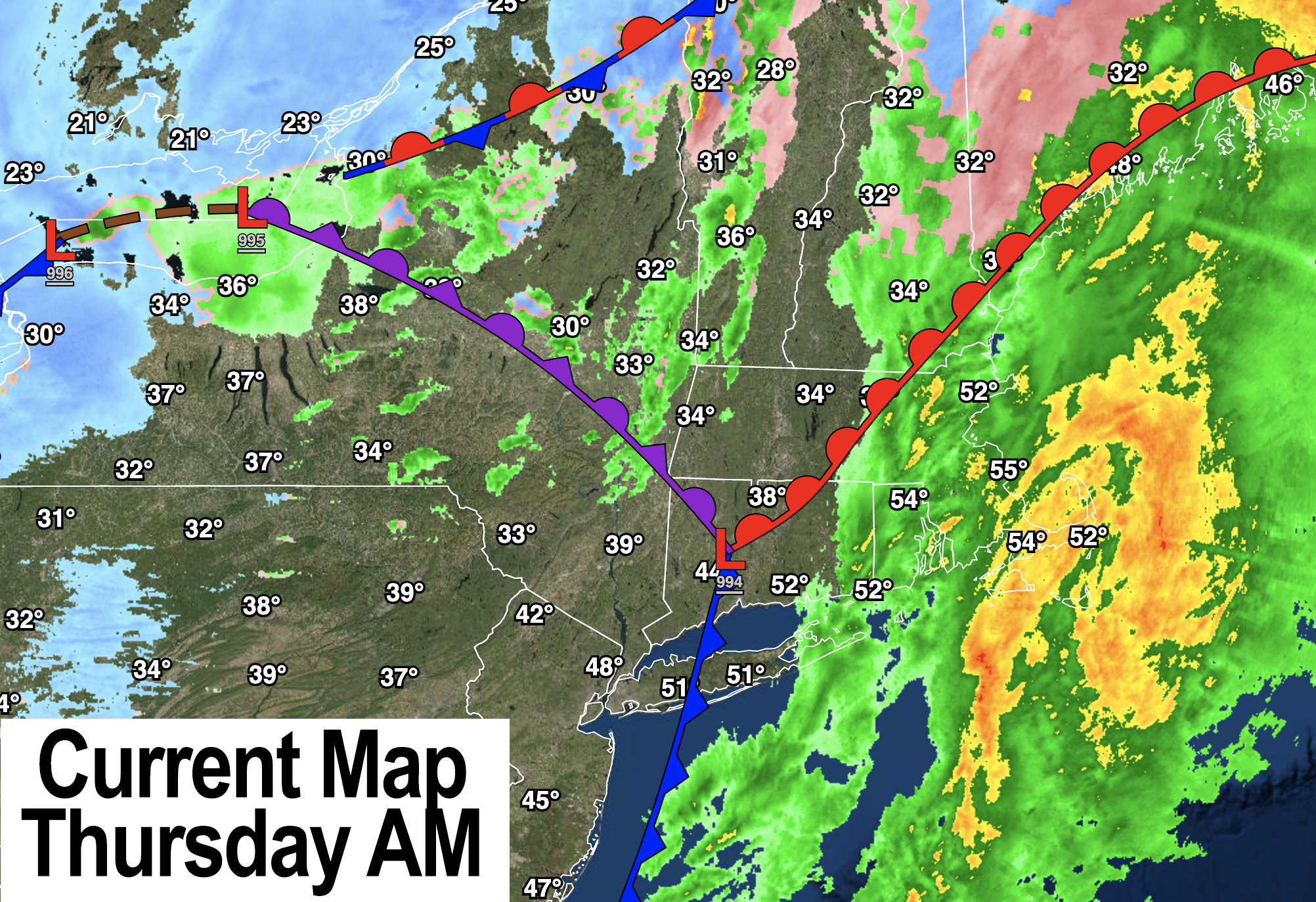
Good morning everybody, not much of a discussion today, other than to say we generally have a more tranquil period of weather coming up through Sunday morning, though today should become windy out of the west and southwest behind a cold front that is moving through the region this morning.
It’s in the 50s in southeast MA and in the 30s in the WMass region so temps will decrease through the day, and winds will increase with a few upslope snow showers over SVT and far northwest MA and the adjacent Taconics in NY.
A light storm system looks to move through the region Sunday into very early Monday, with another bigger storm possible by the middle of next week.
A clash of air masses will be setting up by middle of next week with cold Arctic air pressing south and east into our region, with milder air near the Mid-Atlantic region and southern New England, so a ribbon of precipitation should set up from west-southwest to east-northeast into our region with a wave or two moving along it.
Where exactly this sets up will determine whether we see snow or mixed precip from it. At this time, it’s hard to believe we’d see all rain during the mid-week system, but with the way this winter has gone so far, I’m open to all potentials.
I hope you have a good day and do something you enjoy doing.
Join my Free Weekly Nutletter.
AND REMEMBER…
“Hello babies. Welcome to Earth. It’s hot in the summer and cold in the winter. It’s round and wet and crowded. On the outside, babies, you’ve got a hundred years here. There’s only one rule that I know of, babies: Goddamn it, you’ve got to be kind.”
–Kurt Vonnegut