
WHAT YOU’LL GET WHEN YOU SCROLL
–Weekly Nutshell (Quick impact list)
–Sponsor Note (Tandem Bagel Co.)
–NWS Alerts (Advisories, Warnings, Watches)
–Celestial Data (Sun/Moon info)
–Morning Discussion (Longer-form explanation)
——————————-
DAVE’S WEEKLY WEATHER NUTSHELL
–Clouds increase this morning
–Flurries or scattered snow showers arrive late morning to early afternoon
–Steadier precipitation shield arrives by mid afternoon with snow into early evening, will impact evening commute
–North of Springfield should be all snow, but near Springfield and south to Hartford could mix with rain this afternoon
–Snow changes to ice and rain between 8pm-11pm south to north
–Some ice accretion / ice glaze before pure rain in northwest hililtowns, northeaster Berkshires and southern VT
–Rain falls heavily at times after midnight, washes away some snow, winds pick up and gust 20-30mph out of the east
–Rain quits by early morning, wind shifts to the west, gusting to 35ph Thursday and Thursday night
–Upslope snow showers in the Berkshires, western hills and SVT adds a coating to an inch or two by Thursday night
–Calm, seasonably cold, and storm-free from Friday through the weekend and into early next week, except for maybe a few mixed showers Sunday night into Monday
–Better chance for a bigger storm next Wed/Thurs as a colder pattern may be moving into New England, but before we jump into the weather discussion/details below, let’s check a note from our local and delicious sponsor, #TandemBagelCo, with their newest location in West Springfield, MA.
——————–
A NOTE FROM OUR SPONSOR:
DHTWN Is Sponsored by Members, Patrons & Tandem Bagel Company: No matter the weather, Tandem Bagel is always there for you at several valley locations to make your mornings brighter! With bagels baked fresh daily (including Gluten-Free options), house-whipped cream cheese, coffee, and tons of lunch options, Tandem is the perfect quick stop for lunch, breakfast, or a coffee and bagel to go. Find them in Easthampton, Northampton, Hadley, Florence, and West Springfield, or use their super-streamlined online ordering tool by visiting their website.
——————————————-
***DHTWN DAILY WEATHER REPORT***
——————————————-
NATIONAL WEATHER SERVICE ALERTS
–Winter Storm Warnings are up for SVT, with Winter Weather Advisories for the rest of the greater WMass region including northern CT
DHTWN REMINDER
–The odds of being a human are 1 in 400,000 billion… make it count, even in a small way (see Kurt Vonnegut quote at end of post)
DAILY CELESTIAL (STAR):
–OUR STAR ROSE AT: 7:09am this morning
–OUR STAR WILL SET AT: 4:55pm this evening
–TOTAL DAYLIGHT TIME: 9 hours and 46 minutes
NIGHTLY CELESTIAL (MOON):
–OUR MOON WILL SET AT: 9:48pm this evening
–OUR MOON WILL RISE AT: 10:06am tomorrow morning
–MOON SET DIRECTION: West
–MOON RISE DIRECTION: East
–MOON PHASE: Waxing Crescent (18.4%)
———————-
DAILY TERRESTRIAL (ZoneCast)
ZONE 1 (Northern Region)
Southern VT, Southwest NH, N. Taconics NY
–High Temps: Low to Mid 30s
–Low Temps: Upper 20s to Low 30s
–Wind: Easterly wind gusts 20-30mph this evening/tonight
–Skies: Becoming overcast
–Precipitation: Flurries/snow showers by noon or so, accumulating snow by mid to late afternoon into the evening, changing to ice or rain before midnight
ZONE 2 (Central Region)
WMass, N. CMass, N. Litchfield County, C./S. Taconics NY
–High Temps: Low to Mid 30s
–Low Temps: Upper 20s to Low 30s
–Wind: Easterly wind gusts 20-30mph this evening/tonight
–Skies: Becoming overcast
–Precipitation: Flurries/snow showers by noon or so, accumulating snow by mid to late afternoon into the evening, changing to ice or rain between 8pm-11pm… snow may mix with rain Springfield south this afternoon at times
ZONE 3 (Southern Region)
S. CMass, S. Litchfield County, NC.CT, & NE.CT
–High Temps: Mid 30s
–Low Temps: Low 30s
–Wind: Easterly wind gusts 20-30mph this evening/tonight
–Skies: Becoming overcast
–Precipitation: Flurries/snow showers by noon or so, snow picks up by mid afternoon and mixes with rain at times, changing to rain between 7-9pm
———————-
WHERE’S DAVE?
1. I’ve been reporting our weather daily here and at https://www.westernmassweather.com for a decade
2. Get my free weekly newsletter here: https://westernmassweather.com/homepage/dhtwn-nutletter-signup/
3. Actively visit this FB page via the app or web, as I may not always auto-kiss your screens
———————-
MORNING DISCUSSION
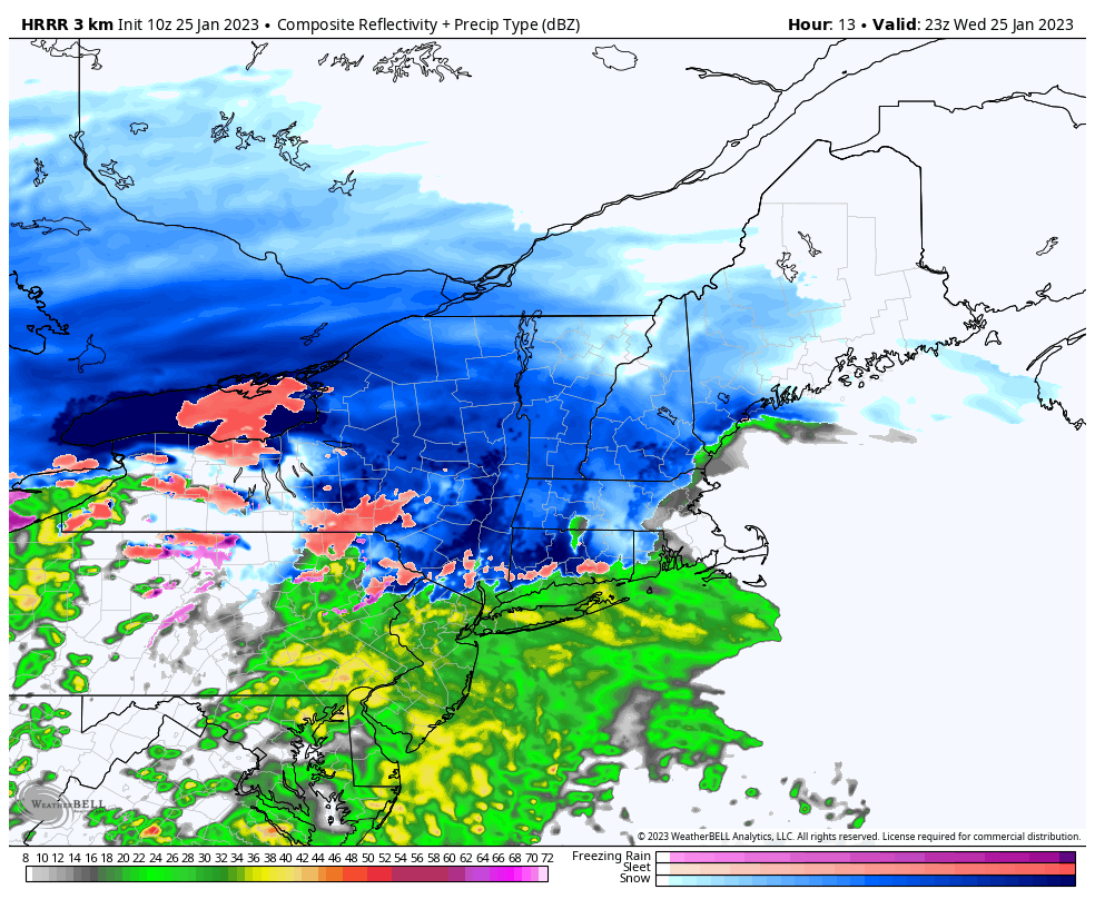
Good morning everybody, another slop storm is on the way with low pressure tracking west of us into New York state and bringing plenty of juice all the way from the Gulf of Mexico.
If this storm track were 200-300 miles east, we’d be dealing with a classic Miller A run-the-eastern-seaboard major snow storm which are the kind that put the pause button on the WMass Snow Lover’s Triangle of Disappointment.
But, that is not this storm, as we will be seeing once again mild air surge north on the east side of our western / inside-runner storm track, with snow changing to ice and rain overnight, so let’s get down to business.
For this morning, clouds thicken and temps will rise up into the low to mid 30s across the region. Again, these marginal temps are more likely than not to combine with easterly and southeasterly flow to allow a mix with rain to occur from the Hartford area up to Springfield area later this afternoon.
However, most of us should all start as snow, with snow showers by late morning to early afternoon, then steady snow by mid afternoon with light accumulations by the evening commute, so give yourself extra travel time when heading home from work if you have that more traditional schedule (which not everybody has).
Snow will fall moderately to heavily late this afternoon into very early evening, and then change from snow to ice or rain (depending on elevation, mostly) between 8pm-11pm from northern CT up to SVT/SWNH as mild air surges rapidly.
Some prolonged icing may occur in the western hilltowns, eastern Berkshires and mountains of SVT before going to rain there after midnight.
It will rain hard at times overnight, and some isolated outages may occur due to pre-existing snow loading, snow on top, and then ice/rain on top of that, so be prepared if you live at elevation where trees still have snow on them.
Everything quits by early morning, and east winds gusting 20-30mph switch to the west and gust 25-35mph by Thursday afternoon into the evening as we run up into the upper 30s to mid 40s for a day Thursday, and then cool off down in the low 20s at night with some refreezing and black ice patches.
AMOUNTS
Despite my tweet of this morning, I am going to leave amounts at 2-5″ across the region with more like 4-8″ from western Hampshire, western Franklin, northeast Berkshire Counties in MA up into the southern Greens of SVT. It is possible that if the precip shield is not as solid and milder air surges faster, we’ll see lower ends of those ranges.
In addition, I think that much of northern CT will see a 1-2″, and that could crawl up into the Holyoke/Springfield area with under 2″ not out of the question in Northampton/Amherst area, but we’ll see how it all plays out.
Also, we should see upslope snow showers in SVT and the northern Berkshires/Taconics with a coating to 2″ possible of additional snow Thursday afternoon into the evening.
Friday through early next week looks calm, seasonably cold, and without storms, except for a few mixed showers Sunday night into Monday.
It’s the mid to late week period into next weekend that has my attention as we may be undergoing a pattern shift to more wintry conditions with a storm opening that icy door by next Thursday, but it’s a long way off, and lots can change, so let’s deal with what’s in front of us today.
To that end, I will be posting an update by early afternoon and again this evening with updates, have a great day peeps!
Join my Free Weekly Nutletter.
AND REMEMBER…
“Hello babies. Welcome to Earth. It’s hot in the summer and cold in the winter. It’s round and wet and crowded. On the outside, babies, you’ve got a hundred years here. There’s only one rule that I know of, babies: Goddamn it, you’ve got to be kind.”
–Kurt Vonnegut