
WHAT YOU’LL GET WHEN YOU SCROLL
–Weekly Nutshell (Quick impact list)
–Sponsor Note (Tandem Bagel Co.)
–NWS Alerts (Advisories, Warnings, Watches)
–Celestial Data (Sun/Moon info)
–Morning Discussion (Longer-form explanation)
——————————-
DAVE’S WEEKLY WEATHER NUTSHELL
–Temps start in the 20s to low 30s this morning
–Westerly wind gusts will blow to 25-35mph at times, and slacken later this afternoon
–Mostly cloudy skies north and west, partly sunny skies valley south and east, after morning cloudines w/ highs in the 30s
–Cold night in the upper teens sets up Wednesday’s front-end snow thump arriving early to mid afternoon and snowing into the evening before changing to ice then rain before or around midnight
–Evening commute will be negatively impacted, so allow extra time to get home
–Overnight rain showers dry up to drizzle by early morning with gusty winds into Thursday, and upslope snow showers in the Berkshires, western hilltowns and southern Greens Thursday afternoon with more light accumulation possible
–Friday is cold and sunny, and the weekend is seasonable and more cloudy, with light snow showers possible Sunday night into Monday, but before we jump into the weather discussion/details below, let’s check a note from our local and delicious sponsor, #TandemBagelCo, with their newest location in West Springfield, MA.
——————–
A NOTE FROM OUR SPONSOR:
DHTWN Is Sponsored by Members, Patrons & Tandem Bagel Company: No matter the weather, Tandem Bagel is always there for you at several valley locations to make your mornings brighter! With bagels baked fresh daily (including Gluten-Free options), house-whipped cream cheese, coffee, and tons of lunch options, Tandem is the perfect quick stop for lunch, breakfast, or a coffee and bagel to go. Find them in Easthampton, Northampton, Hadley, Florence, and West Springfield, or use their super-streamlined online ordering tool by visiting their website.
——————————————-
***DHTWN DAILY WEATHER REPORT***
——————————————-
NATIONAL WEATHER SERVICE ALERTS
–Winter Storm Watches are up for all of WMass, SVT, SWNH, and northern CMass for Wednesday afternoon into the pre-dawn hours of Thursday morning
DHTWN REMINDER
–The odds of being a human are 1 in 400,000 billion… make it count, even in a small way (see Kurt Vonnegut quote at end of post)
DAILY CELESTIAL (STAR):
–OUR STAR ROSE AT: 7:10am this morning
–OUR STAR WILL SET AT: 4:54pm this evening
–TOTAL DAYLIGHT TIME: 9 hours and 44 minutes
NIGHTLY CELESTIAL (MOON):
–OUR MOON WILL SET AT: 8:33pm this evening
–OUR MOON WILL RISE AT: 9:43am tomorrow morning
–MOON SET DIRECTION: West
–MOON RISE DIRECTION: East
–MOON PHASE: Waxing Crescent (10.3%)
———————-
DAILY TERRESTRIAL (ZoneCast)
ZONE 1 (Northern Region)
Southern VT, Southwest NH, N. Taconics NY
–High Temps: Upper 20s to Mid 30s
–Low Temps: Mid to Upper Teens
–Wind: West winds gust 25-35mph, less tonight
–Skies: Mostly Cloudy southern VT, partly sunny southwest NH
–Precipitation: None
ZONE 2 (Central Region)
WMass, N. CMass, N. Litchfield County, C./S. Taconics NY
–High Temps: Mid to Upper 30s, some low 30s northern Berkshires
–Low Temps: Upper Teens to Low 20s
–Wind: West winds gust 25-35mph, less tonight
–Skies: Mostly Cloudy Berkshires/Taconics, partly sunny elsewhere after morning clouds
–Precipitation: None
ZONE 3 (Southern Region)
S. CMass, S. Litchfield County, NC.CT, & NE.CT
–High Temps: Mid to Upper 30s
–Low Temps: Low to Mid 20s
–Wind: West winds gust 20-30mph, less tonight
–Skies: Partly sunny west, mostly sunny east
–Precipitation: None
———————-
WHERE’S DAVE?
1. I’ve been reporting our weather daily here and at https://www.westernmassweather.com for a decade
2. Get my free weekly newsletter here: https://westernmassweather.com/homepage/dhtwn-nutletter-signup/
3. Actively visit this FB page via the app or web, as I may not always auto-kiss your screens
———————-
MORNING DISCUSSION
Good morning everybody, another day another storm to report on, so let’s jump right into it, get down to business, make it happen, seize the day, do the right thing, engage, and make it so!
We’re starting off milder than I anticipated with temps in the 20s and low 30s, and also with plenty of clouds around.
Clouds will be stubborn in southern VT and the Berkshires/Taconics today, but we should transition to a mostly cloudy west to partly sunny east from the Berkshires through WMass to Worcester County today (and the associated reflections of SVT to SWNH and same for the northwest corner to northeast corner of CT: cloudier west, sunnier east).
Highs will reach well into the 30s across the region, low 30s north and west, upper 30s south and east, mid 30s generally in the valley of WMass.
West winds will gust 25-35mph during the morning and into the afternoon, and then should slacken this evening.,
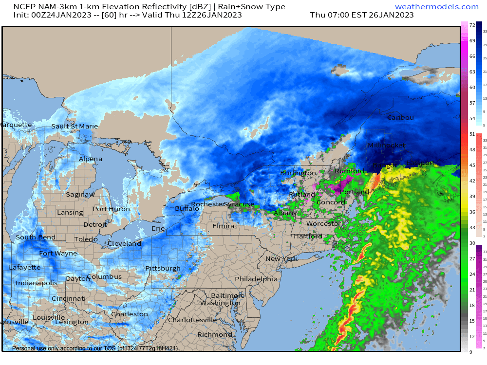
It looks like we’ll have partly cloudy skies tonight with lows in the teens and 20s, which sets up our surface-based cold overrunning air mass which will lie in wait for a nice slug of warm frontal precipitation to slam into it Wednesday afternoon, glide over and on top of it, and produce snow region-wide between 1-3pm and lasting through the evening commute, covering surfaces everywhere.
Wednesday will cloud up and highs should only reach the upper 20s to low 30s, and it could be snowing heavily at times during the drive home, so give yourself extra time and take it easy on road ways.
Sometime between 7-9pm snow will start to change to ice and rain in northern CT up to the MA line, and between 9pm to midnight that change line should push rapidly north up into SVT and SWNH.
Some areas in the high terrain may see a period of freezing rain with a tenth of an inch of ice accretion, so travel will not be advised before midnight tomorrow night.
Easterly wind is likely to enhance snow totals in the western hilltowns, eastern Berkshires and southern Greens of VT, and possibly for some of the northern CMass hilltops, too.
AMOUNTS
It looks like a solid 3-6″ will be widespread across the region before the changeover, with the eastern Berkshires, western hilltowns and southern Greens of VT seeing 6-10″, and more like 4-8″ in northern Worcester County up into southwest NH.
It’s possible that the bottom of the disappointment triangle from Hartford to Springfield sees under 3″, but we’ll see.
Once we flip to rain into the pre-dawn hours of Thursday morning, it should wrap up by dawn and scoot on out of here as the storm rips northeast through NY state to our west and up the St. Lawrence River Valley in Canada.
Gusty winds will blow behind the system, blowing out of the west and up to 30mph or so as highs briefly crest into the low 40s or so before crashing into the teens at night, with westerly gusts and blustery conditions continuing.
We should see some upslope snow showers develop Thursday afternoon and evening in the Taconics, Berkshires and SVT with additional light accumulations possible.
Friday looks cold and sunny with highs in the 20s and lows in the teens, and then we cloud up over the weekend with a wave passing to our north Saturday, and then a weak system moving closer Sunday, but not reaching us with snow or rain showers until Sunday night into Monday.
Have a great day, and I will update again tonight!
AND REMEMBER…
“Hello babies. Welcome to Earth. It’s hot in the summer and cold in the winter. It’s round and wet and crowded. On the outside, babies, you’ve got a hundred years here. There’s only one rule that I know of, babies: Goddamn it, you’ve got to be kind.”
–Kurt Vonnegut