
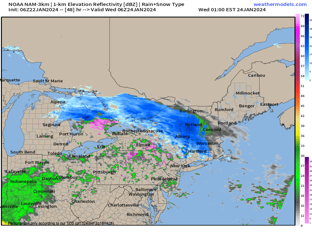
Tuesday night snow
TABLE OF CONTENTS
* Daily Celestials (Sun/Moon Data)
* Weekly Weather Nutshell
* Morning Discussion
* TIP: Scroll below for sections, or read all
~~~~~~~~~~~~~~~~~~~~~~
YOUR DAILY CELESTIALS
~~~~~~~~~~~~~~~~~~~~~~
STAR:
–OUR STAR WILL RISE AT: 7:12am this morning
–OUR STAR WILL SET AT: 4:51pm this evening
–TOTAL DAYLIGHT TIME: 9 hours and 39 minutes
MOON:
–OUR MOON WILL RISE AT: 1:41pm this afternoon
–MOON RISE DIRECTION: Northeast
–OUR MOON WILL SET AT: 6:07am tomorrow morning
–MOON SET DIRECTION: Northwest
–MOON PHASE: Waxing Gibbous (89.5%)
~~~~~~~~~~~~~~~~~~~~~~
A NOTE FROM OUR SPONSOR
~~~~~~~~~~~~~~~~~~~~~~
Dave Hayes The Weather Nut is Sponsored by Individual Community Members, Patrons, and Tandem Bagel Company… No matter the weather, Tandem Bagel is always there for you at several valley locations to make your mornings brighter! With bagels baked fresh daily (including Gluten-Free options), house-whipped cream cheese, coffee, and tons of lunch options, Tandem is the perfect quick stop for lunch, breakfast, or a coffee and bagel to go. Find them in Easthampton, Northampton, Hadley, Florence, and West Springfield, or use their super-streamlined online ordering tool by visiting their website.
~~~~~~~~~~~~~~~~~~~~~~
YOUR WEEKLY WEATHER NUTSHELL
~~~~~~~~~~~~~~~~~~~~~~
–Early sunshine gives way to increasing clouds today
–Cold temps in the single digits and teens rise into the low to mid 30s on southwest gusts of 10-20mph
–A few afternoon mixed showers are possible, but likely dry
–Clouds increase tonight, lows mid to upper 20s
–Overcast tomorrow with highs rising into the mid 30s for many of us as precip moves in by mid-day to early afternoon
–This is likely mixed between snow, sleet and rain, trending to snow by Tuesday evening as cold air drains south from high pressure to the north
–A coating to 2″ is expected, and by Wednesday morning a period of light freezing rain may develop
–Winter Weather Advisories will probably be hoisted by NWS later today or early Tuesday
–After mixed precip quits Wednesday morning, we lull out, but another system passes to our west, inducing milder highs to rise into the 40s for Thursday and Friday, along with periods of rain
–These mild temps last into Saturday, but colder air will start to work back into the region by Sunday with highs 35-40º
–At night, we may see a coastal snowstorm develop over the region as a low passes off of the northern Miid-Atlantic coastline and heads south of Nantucket Island, so stay tuned, as Monday morning’s commute could be impacted
~~~~~~~~~~~~~~~~~~~~~~
YOUR MORNING DISCUSSION
~~~~~~~~~~~~~~~~~~~~~~
Good morning everybody, we are very cold this morning, but what’s interesting is that temps are milder in the high terrain (teens) when compared with the Pioneer Valley (single digits above and below zero).
This is due to a temperature inversion. Inversions refer to temps being milder aloft compared to the ground, which is the opposite of normal given that temps usually cool down as you head out into Outer Space, man, like wow!
Sun early will give way to clouds as two giant high pressure cells set up to our south and (by tomorrow evening) another to our north in Quebec.
The latter cell will drain cold air south into the WMass region for Tuesday later afternoon and overnight into early Wednesday morning.
The two cells will provide a path for a weaker wave and area of moisture to squeeze east between the two and right into our region Tuesday into Wednesday morning.
So, today is trending more cloudy with highs in the low to mid 30s and a mixed shower or two possible, followed by a dry cloudy night with lows in the mid to upper 20s.
We’re overcast on Tuesday, and mixed precip (snow, sleet, and/or rain) arrives by mid-day into early afternoon from west to east.
As we move into the night, cold air continues to drain and drops highs from the mid to upper 30s down into the 20s and we should turn to all snow, accumulating a coating to 2″ overnight.
By morning, milder air works in aloft, and we could see a period of freezing rain develop for the Wednesday morning commute, so impacts are looking more likely to slow travel.
Precip abates later Wednesday with highs in the upper 30s, but our frontal boundary will stick around the region, and combine with another system tracking west of us on Thursday to raise temps into the 40s for highs Thursday through Saturday, and to bring periods of rainfall Thursday, Thursday night and part of Friday.
Saturday looks dry, but Sunday looks colder as another storm system develops south of us off of the Mid-Atlantic coastline.
If this system tracks close enough to us, we could see accumulating snow late Sunday night into the Monday morning commute, so stay tuned for updates and have a great day!
>>> BE KIND <<<
“Hello babies. Welcome to Earth. It’s hot in the summer and cold in the winter. It’s round and wet and crowded. On the outside, babies, you’ve got a hundred years here. There’s only one rule that I know of, babies: Goddamn it, you’ve got to be kind.”
–Kurt Vonnegut