
TABLE OF CONTENTS
* Daily Celestials (Sun/Moon Data)
* Weekly Weather Nutshell
* Morning Discussion
* TIP: Scroll below for sections, or read all
~~~~~~~~~~~~~~~~~~~~~~
YOUR DAILY CELESTIALS
~~~~~~~~~~~~~~~~~~~~~~
STAR:
–OUR STAR WILL RISE AT: 7:13am this morning
–OUR STAR WILL SET AT: 4:50pm this evening
–TOTAL DAYLIGHT TIME: 9 hours and 37 minutes
MOON:
–OUR MOON WILL RISE AT: 12:53pm this afternoon
–MOON RISE DIRECTION: East-Northeast
–OUR MOON WILL SET AT: 5:10am tomorrow morning
–MOON SET DIRECTION: West-Northwest
–MOON PHASE: Waxing Gibbous (83.2%)
~~~~~~~~~~~~~~~~~~~~~~
>>> A NOTE FROM OUR SPONSOR <<<
Dave Hayes The Weather Nut is Sponsored by Individual Community Members, Patrons, and Gerard, Ghazey & Bates, P.C. GGBPC is a Northampton-based law firm regarded as the voice of pragmatic and well-reasoned estate planning, elder law and tax guidance in Western Massachusetts. The firm specializes in estate planning law, and expertly handles other matters such as Elder Law, Tax Law, as well as Real Estate purchase, sales, and refinance transactions. Contact GGBPC today to see how they can help!
~~~~~~~~~~~~~~~~~~~~~~
YOUR WEEKLY WEATHER NUTSHELL
~~~~~~~~~~~~~~~~~~~~~~
–Below Zero Wind chills will abate this morning
–With highs in the upper teens to mid 20s under sunny skies, and northwest winds gusting to 20-30mph, wind chills might get back down into the single digits above zero at times
–Lows tonight in the mid single digits to low teens for one more frigid night before temps moderate all week long
–Monday may start off sunny, but clouds will build in with time
–Highs will moderate, reaching the low to mid 30s as high and mid clouds thicken, with lows in the 20s as more tolerable temps emerge
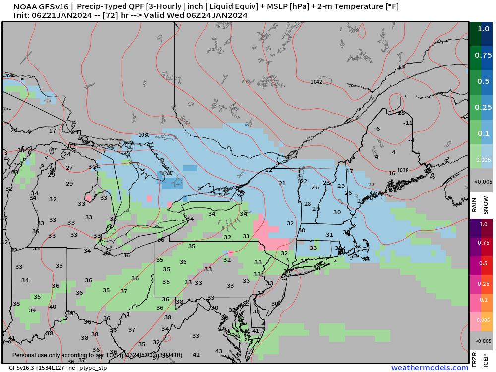
–Clouds thicken on Tuesday as a weak wave and frontal boundary approaches New England and sets up between cold high pressure to our northeast and warmer high pressure to our south
–This temperature battle zone will produce a ribbon of precipitation that pushes into the region as early as later afternoon on Tuesday with mixed precip
–Signals continue to point to a cold air damming signal and cold drain into our region
–This should more likely than not cause accumulating snow Tuesday night, though it would be a light event like a 1-3″ or 2-4″ type deal as temps pull back into the upper 20s
–This has ramifications for the Wednesday morning commute so stay tuned for updates
–Any snow would likely turn to a mix or rain as Wednesday morning wears on as mild air surges and the cold rain loses the battle
–By Wednesday afternoon through Saturday it looks like a ridge sets up in the eastern U.S.
–This will create milder than average temps with highs in the 40s and lows in the 30s through this period
–Additionally, a frontal boundary will become stationary Wednesday into Thursday which will focus some rain showers
–Then another storm will track inland, and bring some rain Thursday night into Friday
–Saturday looks like a break in the action before another storm may arrive Sunday night and possibly bring wintry precipitation to the region
~~~~~~~~~~~~~~~~~~~~~~
YOUR MORNING DISCUSSION
~~~~~~~~~~~~~~~~~~~~~~
Good morning everybody, we’ve had a very cold start to the day with wind chills in the double-digits below zero over the Berkshires and western hilltowns up into SVT.
The core of the cold is slowly exiting, but we do have one more 24-hour period of frigid temperatures to move through before we truly start climbing back up towards average temps early this week, and above average mid to late week into next weekend (which means 40s for highs).
Winds gusted between 30-40mph overnight in the Berkshires, but have tamped down to the 15-30mph range, and will abate later today, but wind chills in the single digits above zero are still possible this afternoon under sunny skies.
The Nutshell above covers most of the salient points of our incoming weather, but the main impact (which would be a minor system overall) is Tuesday night into early Wednesday morning as a clash of cold and warm air sets up over southern New England.
The mild air eventually wins out mid to late week, but not before fleeting cold high pressure north of New England delivers one last cold drain southwest into our region before we fully shift the pattern to a milder setup.
These converging air masses combine with a subtle wave to produce about two-tenths to a third of an inch of precip Tuesday night into early Wednesday, with cold air dropping lows into the upper 20s, an overrunning warm advection snow event will set up with 1-4″ of snow possible, which could slow the Wednesday morning commute.
Beyond that, we get milder and showery into the late week period, but might get another well-timed (for snow lovers) storm to arrive late Sunday night which may create some more snow or mixed precipitation leading into the Monday morning commute.
So, a pretty active and changing pattern is upcoming (though with no big storms) and I will keep you updated, have a great day!
>>> BE KIND <<<
“Hello babies. Welcome to Earth. It’s hot in the summer and cold in the winter. It’s round and wet and crowded. On the outside, babies, you’ve got a hundred years here. There’s only one rule that I know of, babies: Goddamn it, you’ve got to be kind.”
–Kurt Vonnegut