
NWS Boston Wind Chills
TABLE OF CONTENTS
* Daily Celestials (Sun/Moon Data)
* Weekly Weather Nutshell
* Morning Discussion
* TIP: Scroll below for sections, or read all
~~~~~~~~~~~~~~~~~~~~~~
YOUR DAILY CELESTIALS
~~~~~~~~~~~~~~~~~~~~~~
STAR:
–OUR STAR WILL RISE AT: 7:13am this morning
–OUR STAR WILL SET AT: 4:49pm this evening
–TOTAL DAYLIGHT TIME: 9 hours and 36 minutes
MOON:
–OUR MOON WILL RISE AT: 12:14pm this afternoon
–MOON RISE DIRECTION: East-Northeast
–OUR MOON WILL SET AT: 4:05am tomorrow morning
–MOON SET DIRECTION: West-Northwest
–MOON PHASE: Waxing Gibbous (73.8%)
~~~~~~~~~~~~~~~~~~~~~~
>>> A NOTE FROM OUR SPONSOR <<<
Dave Hayes The Weather Nut is Sponsored by Individual Community Members, Patrons, and Gerard, Ghazey & Bates, P.C. GGBPC is a Northampton-based law firm regarded as the voice of pragmatic and well-reasoned estate planning, elder law and tax guidance in Western Massachusetts. The firm specializes in estate planning law, and expertly handles other matters such as Elder Law, Tax Law, as well as Real Estate purchase, sales, and refinance transactions. Contact GGBPC today to see how they can help!
~~~~~~~~~~~~~~~~~~~~~~
YOUR WEEKLY WEATHER NUTSHELL
~~~~~~~~~~~~~~~~~~~~~~
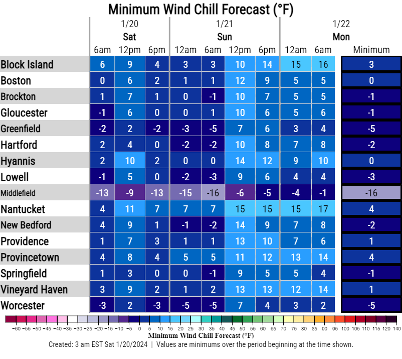
–Very cold start today with temps in the single digits to low 10s
–Northwest winds gusting 15-25mph overnight are placing wind chills down into the single digits above and below zero
–Some parts of the Berkshires are less than -10º for wind chill!
–Today will be the coldest day of the season thus far with highs only in the low to mid teens
–In other news, I am 15% smarter this morning as I realized that “teen” comes from ten, meaning fifteen is the same as “five-ten”
–I’m slow on the draw, but I keep plugging away!
–Back to the weather, it will be mostly cloudy (especially this afternoon) with a few snow showers possible
–Northwest winds gust 20-30mph today, which keeps wind chills in the single digits above AND below zero, so bundle up!
–Tonight we have Wind Chill Advisories hoisted for the Berkshires and western hilltowns
–Wind chills with continued northwest breezes will drop to 10º to 20º below zero with air temp lows firmly in the single digits region-wide, with SVT possibly getting below zero for the low air temp!
–On Sunday, northwest breezes are around but relenting, and sunshine will return as high pressure starts tracking east along the southern half of the U.S. towards the coast
–Highs should reach the upper teens to mid 20s with lows either side of 10º
–Monday will be the last sunny day for a while with milder highs in the low to mid 30s as flow turns southwest
–Clouds move in Monday night with lows in the low to mid 20s
–By Tuesday clouds thicken as cold high pressure to our northeast and high pressure to our south cause converging air and a temperature clash over our region
–This should produce a light to moderate precip event, and would probably start as accumulating snow in the WMass region
–A few inches would be possible Tuesday night into early Wednesday morning before mixing with ice and rain
–Tuesday and Wednesday should feature highs in the 30s with lows in the 20s
–By Thursday a stationary front could focus some showers in the region, but another storm looks to push through within a milder air envelope
–With highs in the 40s late week, we could end the week with a rainstorm Thursday night into Friday
~~~~~~~~~~~~~~~~~~~~~~
YOUR MORNING DISCUSSION
~~~~~~~~~~~~~~~~~~~~~~
Good morning everybody, the next 24 hours will be a time to limit time outside unless you’re properly bundled, as the coldest air of the new year and winter season seeps into the region on northwest gusts of 15-25mph, with a few higher gusts possible.
We may see some sunny peeks, but it should turn into a mostly cloudy day as a weak wave moves through with a few snow showers possible.
Highs will only be in the low to mid teens for most of us, but wouldn’t be surprised if southern VT saw highs in the single digits all day long.
With northwest wind gusts of 15-25mph, wind chills will be in the single digits above AND below zero depending on where you are, so cover up your body surfaces!
Tonight we head into the freezer, with Wind Chill Advisories hoisted, and chill readings heading into the 10º to 20º BELOW ZERO overnight as blustery conditions continue, and lows firmly in the single digits, and probably below zero in parts of SVT/SWNH and far northwest MA.
We recover a bit on Sunday under sunny skies, but it’s still a cold day with highs in the upper teens to mid 20s and lows in the single digits to low teens.
While Sunday is our pick of the weekend, Monday is our pick of the week!
Temps will come up with southwest flow as high pressure moves south of us, driving temps into the low to mid 30s under sunny skies. You couldn’t ask for a nicer January day, actually.
Meanwhile, another high pressure will move into position in Quebec through Tuesday.
This high to our south and high to our north will help air converge (i.e. come together and rise) in the greater WMass region Tuesday night after a mostly cloudy Tues Day with highs in the mid to upper 30s.
A band of snow will likely form Tuesday night as our temps dip into the upper 20s, which could accumulate several inches into the Wednesday morning commute before changing to ice and rain, so some impacts are possible.
A front then lollygags about the region like a young version of myself: aimless, hammered, affable, and kinda clueless, and produces some scattered rain showers into Thursday as temps come up above 40º.
Finally, another storm system, this one an inland cutter/runner, will track west of us and bring some rain to the region by end of the week.
That’s the way it looks now, hope you have a great day!
>>> BE KIND <<<
“Hello babies. Welcome to Earth. It’s hot in the summer and cold in the winter. It’s round and wet and crowded. On the outside, babies, you’ve got a hundred years here. There’s only one rule that I know of, babies: Goddamn it, you’ve got to be kind.”
–Kurt Vonnegut