
WHAT YOU’LL GET WHEN YOU SCROLL
–Weekly Nutshell (Quick impact list)
–Sponsor Note (Tandem Bagel Co.)
–NWS Alerts (Advisories, Warnings, Watches)
–Celestial Data (Sun/Moon info)
–Morning Discussion (Longer-form explanation)
——————————-
DAVE’S WEEKLY WEATHER NUTSHELL
–Highs lows to mid 30s today, with lows in the mid 20s, light wind
–Upper level low moves east through the region sparking periods of snow with additional light to moderate accumulations mainly north of the Pike
–A coating to 2″ is expected in most areas including much of the Pioneer valley
–2-5″ is possible in the Berkshires, western hilltowns, southern VT, and also in northern Worcester county and southwest NH
–A coating to an inch is possible in northern CT, but less down there, and some get none where rain and sleet may mix in north up to the Springfield, MA area
–Snow showers abate by mid afternoon but continue into the evening in the Berkshires, western hilltowns, and SVT with upslope snow shower activity
–The weekend looks nicer with Saturday being the pick for sure, with partly sunny skies and highs in the low/mid 30s and lows in the teens
–Sunday is cloudier, and then more snow and rain move in at night with accumulating snow expected in the western hilltowns, Berkshires and southern VT / southwest NH, and possibly into the northern and central Pioneer Valley and northern CMass
–Snow/rain moves out Monday with fair weather into Wednesday when another snow/rain storm arrives, but before we jump into the weather discussion/details below, let’s check a note from our local and delicious sponsor, #TandemBagelCo, with their newest location in West Springfield, MA.
——————–
A NOTE FROM OUR SPONSOR:
DHTWN Is Sponsored by Members, Patrons & Tandem Bagel Company: No matter the weather, Tandem Bagel is always there for you at several valley locations to make your mornings brighter! With bagels baked fresh daily (including Gluten-Free options), house-whipped cream cheese, coffee, and tons of lunch options, Tandem is the perfect quick stop for lunch, breakfast, or a coffee and bagel to go. Find them in Easthampton, Northampton, Hadley, Florence, and West Springfield, or use their super-streamlined online ordering tool by visiting their website.
——————————————-
***DHTWN DAILY WEATHER REPORT***
——————————————-
NATIONAL WEATHER SERVICE ALERTS
–Winter Weather Advisories are up for SVT, SWNH, Berkshires, western hilltowns, Franklin, Hampshire and northern Worcester Counties in MA
DHTWN REMINDER
–The odds of being a human are 1 in 400,000 billion… make it count, even in a small way (see Kurt Vonnegut quote at end of post)
DAILY CELESTIAL (STAR):
–OUR STAR ROSE AT: 7:13am this morning
–OUR STAR WILL SET AT: 4:49pm this evening
–TOTAL DAYLIGHT TIME: 9 hours and 36 minutes
NIGHTLY CELESTIAL (MOON):
–OUR MOON WILL SET AT: 3:10pm this afternoon
–OUR MOON WILL RISE AT: 7:28am tomorrow morning
–MOON SET DIRECTION: Southwest
–MOON RISE DIRECTION: Southeast
–MOON PHASE: Waning Crescent (3.1%)
———————-
WHERE’S DAVE?
1. I’ve been reporting our weather daily here and at https://www.westernmassweather.com for a decade
2. Get my free weekly newsletter here: https://westernmassweather.com/homepage/dhtwn-nutletter-signup/
3. Actively visit this FB page via the app or web, as I may not always auto-kiss your screens
———————-
MORNING DISCUSSION
Good morning, well just about everything but the kitchen sink came out of the sky yesterday including thunder and lightning for some.
In addition, that expected late-night thump of snow materialized but further east then thought, as Fitchburg, MA in northeast Worcester County reported 4.8″ with 5.5″ in Ashby and Ashburnham just over the border into far NW Middlesex County.
Did anyone in southwest NH get some of this late-night snow, or did it just remain as mix?
We also have reports of substantial freezing rain ice accretion overnight in the western hilltowns, so please let me know how road conditions are in your area this morning as many of us are at or below freezing, and we did have some freezing drizzle overnight, too, so take it easy on the roads this morning.
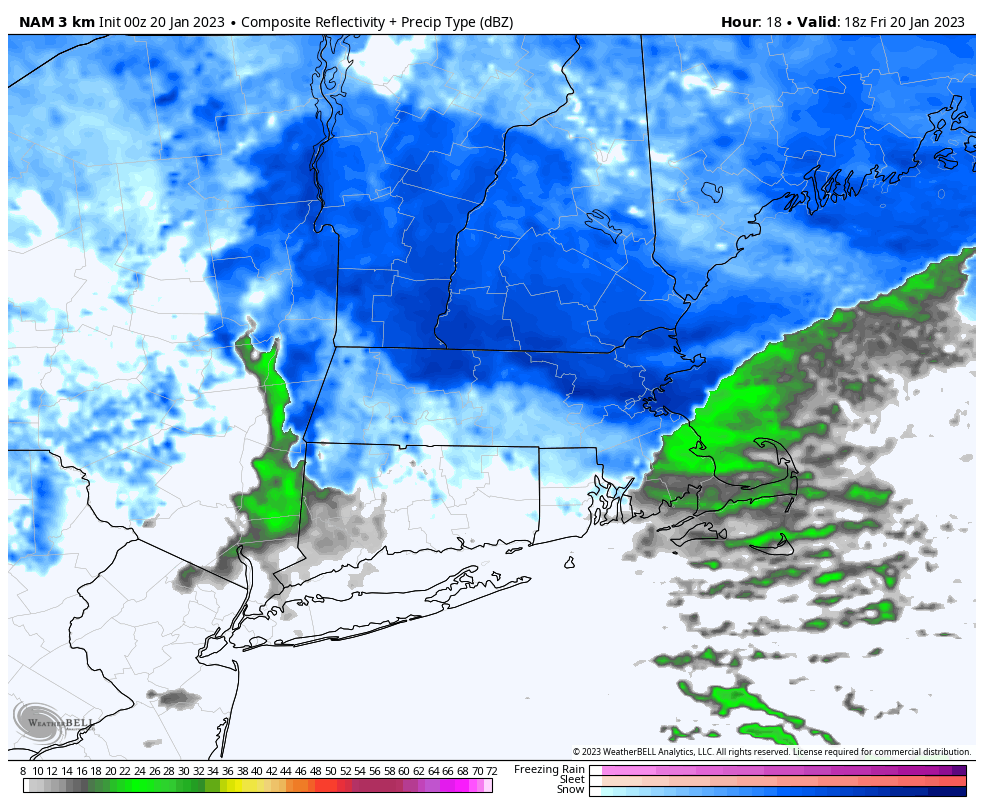
As of 6am, snow showers have already pushed into the Berkshires and Taconics, and we can expect periods of snow to move through the region today, mostly north of the MA/CT state line, but some snow and rain showers will move through Springfield down to Hartford and northern CT.
Our upper low in southern NY state is partially responsible for cooling the column above our heads today to produce snow across the region, as is the strengthening coastal low pulling east.
Additional light accumulations are expected today of about a coating to 2″ for most in WMass and CMass, but a few areas like the Berkshires, western hilltowns, SVT, SWNH and the high terrain along the Rt. 2 corridor in northeast Franklin and northern Worcester Counties could see 2-5″ through tonight.
I think those higher numbers (4″ or 5″), if they materialize, will be relegated mostly to southern VT in the Green Mountains, the Taconics of eastern NY, the Berkshires, and the northwest hilltowns (Cummington and Plainfield up into western Franklin a/k/a “west county”).
Most of the snow shower activity ends by early to mid afternoon for most of us, but will continue in the Berkshires, western hills and SVT with upslope snow effects in the mountains there, ending late tonight.
Highs will reach the low to mid 30s with lows in the 20s tonight, so please watch for black ice patches and slippery spots with new snow and/or any standing water refreezing.
High pressure moves in for the weekend with partly sunny skies on Saturday with highs in the low to mid 30s and lows in the teens for a chilly night.
Sunday becomes mostly cloudy as our next storm ejects out of the southeast and off the Carolina coast headed for southeast MA.
Between this storm and next Wed/Thursday’s storm, the Sunday night into Monday one looks colder and more conducive of snow at the moment.
Still, there will be a snow/rain line that sets up, and right now that looks to be somewhere between the Route 9 or I-90 corridors in MA, with accumulating snow north of there, and it could be a moderate-sized snowfall, say 4-8″ or so, where it stays all snow.
Snow and rain move in Sunday night and last into Monday, quitting by afternoon the way it looks now.
Highs Sunday will be in the mid 30s with lows in the low 30s and highs in the 30s again on Monday.
There is a chance for strong to possibly damaging wind on the back side of that departing low center for Monday afternoon and evening, and temps will be colder down into the low 20s at night.
Brief high pressure builds in Tuesday with partly sunny skies and highs in the 30s, with more storminess on Wednesday afternoon into early Thursday with a snow to rain scenario shaping up, but I will update as we get closer.
Have a great day, and watch for lowered visibility in moderate/steady (and perhaps briefly heavy) snow at times today, as well as some slippery road conditions.
Join my Free Weekly Nutletter.
AND REMEMBER…
“Hello babies. Welcome to Earth. It’s hot in the summer and cold in the winter. It’s round and wet and crowded. On the outside, babies, you’ve got a hundred years here. There’s only one rule that I know of, babies: Goddamn it, you’ve got to be kind.”
–Kurt Vonnegut