
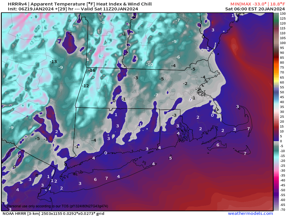
Wind Chills Temps Tonight
TABLE OF CONTENTS
* Daily Celestials (Sun/Moon Data)
* Weekly Weather Nutshell
* Morning Discussion
* TIP: Scroll below for sections, or read all
~~~~~~~~~~~~~~~~~~~~~~
YOUR DAILY CELESTIALS
~~~~~~~~~~~~~~~~~~~~~~
STAR:
–OUR STAR WILL RISE AT: 7:14am this morning
–OUR STAR WILL SET AT: 4:48pm this evening
–TOTAL DAYLIGHT TIME: 9 hours and 34 minutes
MOON:
–OUR MOON WILL RISE AT: 11:42am this morning
–MOON RISE DIRECTION: East-Northeast
–OUR MOON WILL SET AT: 2:54am tomorrow morning
–MOON SET DIRECTION: West-Northwest
–MOON PHASE: Waxing Gibbous (64.4%)
~~~~~~~~~~~~~~~~~~~~~~
A NOTE FROM OUR SPONSOR
~~~~~~~~~~~~~~~~~~~~~~
Dave Hayes The Weather Nut is Sponsored by Individual Community Members, Patrons, and Tandem Bagel Company… No matter the weather, Tandem Bagel is always there for you at several valley locations to make your mornings brighter! With bagels baked fresh daily (including Gluten-Free options), house-whipped cream cheese, coffee, and tons of lunch options, Tandem is the perfect quick stop for lunch, breakfast, or a coffee and bagel to go. Find them in Easthampton, Northampton, Hadley, Florence, and West Springfield, or use their super-streamlined online ordering tool by visiting their website.
~~~~~~~~~~~~~~~~~~~~~~
YOUR WEEKLY WEATHER NUTSHELL
~~~~~~~~~~~~~~~~~~~~~~
–Snow showers and flurries today, but unlikely to be steady enough to do more than coat the ground in spots north of the Pike
–Coating to an inch along and south of the Pike possible
–Cold with highs in the 20s
–Snow showers/flurries end this evening, with colder northwest flow pulling in behind the storm
–Northwest wind should gust up to 20mph or so at times, and with lows in the singles to low teens, wind chills go below zero at times overnight
–Saturday looks cloudy as a mid level moisture-starved system works east through the region
–Highs will only reach the mid to upper teens with northwest breezes keeping wind chills in the single digits above zero
–A few snow showers are possible in the high terrain west of the I-91 corridor
–Lows plummet into the single digits with below zero wind chills once again, so we’re entering the heart of the cold tonight through tomorrow night
–Sunday is nicer as high pressure begins to build south of us with temps coming up to either side of 30º with sunshine
–One more cold night with lows in the low to mid teens, and then on Monday we climb up to more average January high temps with highs in the low to mid 30s under mostly sunny skies and less wind
–On Tuesday, highs should remain in the 30s with clouds building in later in the day
–A warm front will be pressing northeast as temps cool off Tuesday night, and remnant cold air aloft should be enough to help foster accumulating snow Tuesday night into Wednesday, changing to ice and rain so the Wednesday AM commute may be affected
–Another system looks to track well west of us Wednesday night into Thursday which could bring more of a rainy setup
~~~~~~~~~~~~~~~~~~~~~~
YOUR MORNING DISCUSSION
~~~~~~~~~~~~~~~~~~~~~~
Good morning everybody, we’re starting off mostly cloudy this morning and clouds will thicken through the day.
Our storm system today is more of a Mid-Atlantic snow producer than a southern New England one, and while 1-4″ is possible along southern CT, RI and far southeast MA and the Cape/Islands, I think we’ll be “lucky” to see a coating to an inch along and south of the Pike in southern WMass/CMass down into northern CT.
Maybe Litchfield County can bump over an inch, but you get the picture: this storm is a story about the land of #NoBigWhoopinigton, a land where fine grains of snow cascade downward intermittently and produce a whole lot of #NotMuch north of the Pike, though some scattered coatings are possible.
The “height” of this very minor event for the WMass region will be around mid day through afternoon, when some of us could see a period of mostly light accumulating snow, but again, I’m favoring southern areas for such a potential.
For temps and other such details, please see the Nutshell above, but the main story over the next few days is the coldest air of the Winter season is arriving tonight through Sunday morning.
Northwest gusts up to 20mph or so behind our departing ocean low will bring the cold, with lows mostly in the single digits to low teens tonight, and single digits only tomorrow night.
Wind chill readings will go below zero at times tonight and tomorrow night, and with highs under cloudy skies on Saturday only reaching the mid to upper teens, wind chills will be in the single digits tomorrow, with a few afternoon snow showers possible west of I-91 as a wave works through the region.
Sunday is the pick of the weekend with sunshine and more tolerable January highs either side of 30º with lows in the teens.
Monday is lovely with sunny highs in the low to mid 30s. Tuesday starts off nice but clouds up in the afternoon, and then the Tuesday night into Thursday timeframe looks unsettled with a couple of systems bringing some mixed inclement weather.
Of concern is the potential for accumulating snow Tuesday night into early Wednesday morning which could then change to ice and rain.
More rain showers are then possible witih milder temps in the 40s by Thursday, but I will clarify that time period more as we get closer.
Have a great day, and if the ground gets coated, watch for slick spots, as it doesn’t take much given very cold antecedent road surfaces!
>>> BE KIND <<<
“Hello babies. Welcome to Earth. It’s hot in the summer and cold in the winter. It’s round and wet and crowded. On the outside, babies, you’ve got a hundred years here. There’s only one rule that I know of, babies: Goddamn it, you’ve got to be kind.”
–Kurt Vonnegut