
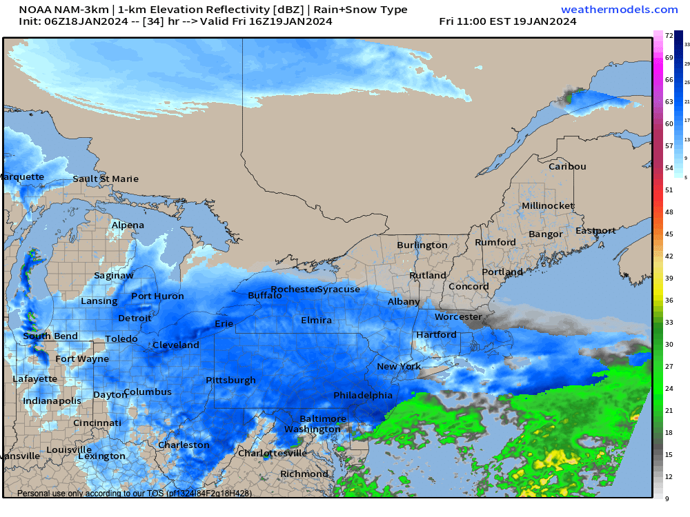
Friday very light snow
TABLE OF CONTENTS
* Daily Celestials (Sun/Moon Data)
* Weekly Weather Nutshell
* Morning Discussion
* TIP: Scroll below for sections, or read all
~~~~~~~~~~~~~~~~~~~~~~
YOUR DAILY CELESTIALS
~~~~~~~~~~~~~~~~~~~~~~
STAR:
–OUR STAR WILL RISE AT: 7:14am this morning
–OUR STAR WILL SET AT: 4:46pm this evening
–TOTAL DAYLIGHT TIME: 9 hours and 32 minutes
MOON:
–OUR MOON WILL RISE AT: 11:15am this morning
–MOON RISE DIRECTION: East-Northeast
–OUR MOON WILL SET AT: 1:41am tomorrow morning
–MOON SET DIRECTION: West-Northwest
–MOON PHASE: Waxing Gibbous (53.8%)
~~~~~~~~~~~~~~~~~~~~~~
A NOTE FROM OUR SPONSOR
~~~~~~~~~~~~~~~~~~~~~~
Dave Hayes The Weather Nut is Sponsored by Individual Community Members, Patrons, and Tandem Bagel Company… No matter the weather, Tandem Bagel is always there for you at several valley locations to make your mornings brighter! With bagels baked fresh daily (including Gluten-Free options), house-whipped cream cheese, coffee, and tons of lunch options, Tandem is the perfect quick stop for lunch, breakfast, or a coffee and bagel to go. Find them in Easthampton, Northampton, Hadley, Florence, and West Springfield, or use their super-streamlined online ordering tool by visiting their website.
~~~~~~~~~~~~~~~~~~~~~~
YOUR WEEKLY WEATHER NUTSHELL
~~~~~~~~~~~~~~~~~~~~~~
–Very cold this morning, temps in the single digits and teens with black ice and everything frozen solid
–We’ll see clouds develop in the region as a weak mid level impulse runs east through the region today
–Winds will gust up to 15-20mph at times, keeping the wind chill on, with highs in the low to mid 20s
–A few snow showers are possible, mainly west of the I-91 corridor in the high terrain of CT, MA and VT
–Lows tonight will drop to the teens with clouds persisting before our Friday system
–For Friday, a storm system develops off of the DelMarVa Peninsula and tracks just about due east or slightly north of due east and pulls its strongest impacts south of us
–Still, we should see a period of snow showers or even some steady light snow starting either side of noon and lasting several hours before pulling south and away
–I think SVT and SWNH likely see a few snow showers and maybe a dusting, but probably nothing
–South of there in WMass, CMass and especially northern CT a coating to an inch should do it for most folks
–Even with that tiny amount of snow, it’s been COLD recently, so slick conditions can develop quickly
–The coldest air of the season pulls in behind our departing system Friday night through Saturday night with blustery conditions developing
–Northwest winds could gust up to 25mph Friday night and with lows in the single digits, wind chills will be going BELOW zero tomorrow night into early Saturday morning
–On Saturday, highs will likely only be in the single digits in the high terrain to teens in the valley with blustery conditions continuing
–Saturday will easily be the coldest day of this Winter to date, both in terms of temps and chill, but at least it will be sunny
–Blustery conditions continue Saturday night with lows in the single digits, and wind chill below zero
–Sunday looks sunny with high pressure getting ready to pass south of the region for the upcoming work week, with highs in the teens and 20s and lows in the single digits with wind slackening by afternoon
–Highs will climb through thee 20s on Monday and well into the 30s for much of next week with some low 40s possible south of the Pike
–While Monday looks to feature fair weather, Tuesday should see clouds building in with the approach of a warm front
–If this warm front pushes through at night, we could see some accumulating snow changing to rain by Wednesday, so stay tuned for details!
~~~~~~~~~~~~~~~~~~~~~~
YOUR MORNING DISCUSSION
~~~~~~~~~~~~~~~~~~~~~~
Good morning everybody, it is quite cold out there this morning, and the cold will be lasting all the way through Sunday night before we open up to the next episode of “The Mildening” which arrives starting this coming Monday.
The Nutshell above covers the most salient weather points of the week ahead, but the overall picture is we get a few snow showers later today, and a period of very light snow tomorrow from mid day into the afternoon with maybe a coating to inch of accumulation.
Watch for black ice and slick spots through the next bunch of days due to frigid temperatures, but also watch tomorrow afternoon, because even a small amount of snow can quickly produce slick conditions, given that our temperatures and surfaces have been so cold recently – it doesn’t take much.
The main weather story over the next several days is that the coldest air of the Winter season is arriving tomorrow night on northwest gusts of 25mph.
Friday night into Sunday looks blustery at times and very cold, so full-on winter conditions will be present and you’ll need to bundle accordingly (please read the nutshell above for details).
We’ll finally get high pressure south of us by early next week and temps will moderate on deep southwest flow.
Still, the timing of a warm frontal approach on Tuesday evening may be such that despite temps near 40º on Tuesday during the day, we could see some accumulating snow at night, so please stay tuned for updates and have a great day!
>>> BE KIND <<<
“Hello babies. Welcome to Earth. It’s hot in the summer and cold in the winter. It’s round and wet and crowded. On the outside, babies, you’ve got a hundred years here. There’s only one rule that I know of, babies: Goddamn it, you’ve got to be kind.”
–Kurt Vonnegut