
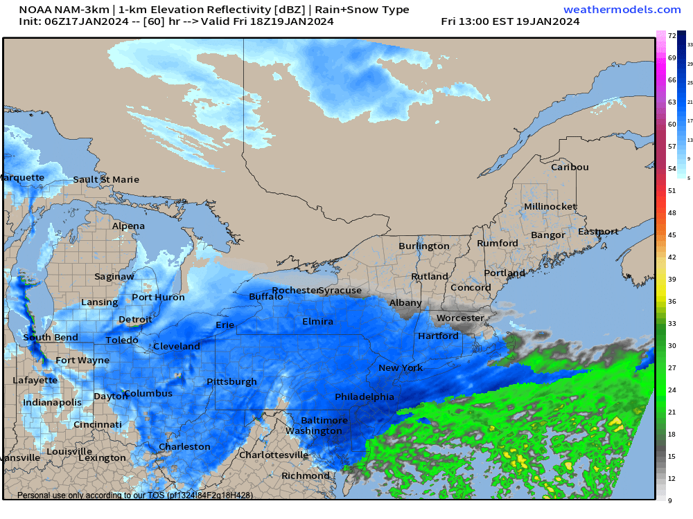
Friday light snow
TABLE OF CONTENTS
* Daily Celestials (Sun/Moon Data)
* Weekly Weather Nutshell
* Morning Discussion
* TIP: Scroll below for sections, or read all
~~~~~~~~~~~~~~~~~~~~~~
YOUR DAILY CELESTIALS
~~~~~~~~~~~~~~~~~~~~~~
STAR:
–OUR STAR WILL RISE AT: 7:15am this morning
–OUR STAR WILL SET AT: 4:45pm this evening
–TOTAL DAYLIGHT TIME: 9 hours and 30 minutes
MOON:
–OUR MOON WILL RISE AT: 10:51am this morning
–MOON RISE DIRECTION: East
–OUR MOON WILL SET AT: 12:28am tomorrow morning
–MOON SET DIRECTION: West-Northwest
–MOON PHASE: Waxing Crescent (42.7%)
~~~~~~~~~~~~~~~~~~~~~~
A NOTE FROM OUR SPONSOR
~~~~~~~~~~~~~~~~~~~~~~
Dave Hayes The Weather Nut is Sponsored by Individual Community Members, Patrons, and Tandem Bagel Company… No matter the weather, Tandem Bagel is always there for you at several valley locations to make your mornings brighter! With bagels baked fresh daily (including Gluten-Free options), house-whipped cream cheese, coffee, and tons of lunch options, Tandem is the perfect quick stop for lunch, breakfast, or a coffee and bagel to go. Find them in Easthampton, Northampton, Hadley, Florence, and West Springfield, or use their super-streamlined online ordering tool by visiting their website.
~~~~~~~~~~~~~~~~~~~~~~
YOUR WEEKLY WEATHER NUTSHELL
~~~~~~~~~~~~~~~~~~~~~~
–Watch for black ice on steps, stoops, sidewalks, driveways, walk ways, and back roads
–Westerly winds gust to 20mph or so today, and slacken a bit later
–Temps in the single digits and teens come up to the upper teens to mid 20s for highs, cold and sunny
–Lows tonight dip into the upper singles to low teens with clouds building toward dawn
–Partly sunny tomorrow with a weak wave and some light snow showers scattered about, highs mid to upper 20s and lows in the teens
–On Friday a pretty strong storm system will likely track well south of our region, east of the DelMarVa Peninsula
–An inverted trough may setup and brush areas of WMass, CMass and northern CT with some light snow along and south of the MassPike
–I can’t rule out a coating to an inch of snow from this system in those areas with a few snow showers or flurries north of there
–Highs in the 20s Friday, drop into the single digits at night behind that departing system
–Saturday will be the coldest day of the Winter so far with highs only in the low to mid teens with lows near zero degrees with clouds early and sunshine developing late in the day
–Sunday looks sunny, with highs in the 20s as southwest flow begins, and we start exiting the current winter pattern
–By early next week we’re rising into the 30s for highs as a ridge develops in the eastern U.S.
–By Tuesday some of us may hit 40º, though if a storm system arrives Tuesday night into Wednesday morning, it may be another snow to rain event setup
–Either way, next week represents our next episode of “The Mildening”… coming to a portable screen near you!
~~~~~~~~~~~~~~~~~~~~~~
YOUR MORNING DISCUSSION
~~~~~~~~~~~~~~~~~~~~~~
Good morning everybody, most folks yesterday saw 2-5″ with only an isolated report or two over 5”, so that was a nice snowfall that wasn’t too tough to take, and now the place is prettied up, and this writer is content for the moment.
It’s cold out, and it’s icy out, so take your time getting going if you’re gettin’ ready to get a move on!
There’s not a whole lot to discuss after the conclusion of Storm Parade of 2024 with 4 impactful storms in the past 9-10 days, three of which were winter weather producers.
Our fifth potential system in this waning pattern looks like it will go out to sea with a whimper, with only a coating to an inch or so possible south of the Pike in southern portions of WMass/CMass, and northern CT.
Otherwise I think the weekly nutshell above covers our upcoming weather conditions pretty well.
In general, it’s breezy and cold today with sunshine, a few flurries or snow showers tomorrow with a very weak wave rippling through, some light snow for southern areas Friday, and then the heart of the cold arrives Friday night through Saturday night into Sunday with milder temps next week along with a possible mid-week snow to rain system.
That does it for now, folks, this writer needs a break and has a to do list a mile long that needs attention, so I will be back here tomorrow morning with an update on our late week snow showery concerns and an update on the arrival of our weekend ice box situation.
Have a great day!
>>> BE KIND <<<
“Hello babies. Welcome to Earth. It’s hot in the summer and cold in the winter. It’s round and wet and crowded. On the outside, babies, you’ve got a hundred years here. There’s only one rule that I know of, babies: Goddamn it, you’ve got to be kind.”
–Kurt Vonnegut