
WHAT YOU’LL GET WHEN YOU SCROLL
–Weekly Nutshell (Quick impact list)
–Sponsor Note (Tandem Bagel Co.)
–NWS Alerts (Advisories, Warnings, Watches)
–Celestial Data (Sun/Moon info)
–Terrestrial Data (Regional Summary Forecasts)
–Morning Discussion (Longer-form explanation)
——————————-
DAVE’S WEEKLY WEATHER NUTSHELL
–Brief bit of sunshine this morning gives way to afternoon clouds as a front approaches the region
–Scattered showers move in by evening and overnight with some light sleet or freezing rain in far northwest MA, SVT and SWNH
–Slippery travel possible early early Wednesday morning in those areas
–Showers leave by tomorrow morning, with developing sunshine and mild temps
–Thursday into Friday looks quite inclement with mixture of snow, ice and rain
–Accumulating snow looking more likely along and north of Rt. 2 corridor where 3-6″ could pile up by Friday night, maybe a bit more in SVT, less to the south
–Colder over the weekend with sunny skies Saturday and cloudier skies Sunday
–More snow and rain Sunday night into Monday is looking probable, and another storm may run through us by middle of next week, but before we jump into the weather discussion/details below, let’s check a note from our local and delicious sponsor, #TandemBagelCo, with their newest location in West Springfield, MA.
——————–
A NOTE FROM OUR SPONSOR:
DHTWN Is Sponsored by Members, Patrons & Tandem Bagel Company: No matter the weather, Tandem Bagel is always there for you at several valley locations to make your mornings brighter! With bagels baked fresh daily (including Gluten-Free options), house-whipped cream cheese, coffee, and tons of lunch options, Tandem is the perfect quick stop for lunch, breakfast, or a coffee and bagel to go. Find them in Easthampton, Northampton, Hadley, Florence, and West Springfield, or use their super-streamlined online ordering tool by visiting their website.
——————————————-
***DHTWN DAILY WEATHER REPORT***
——————————————-
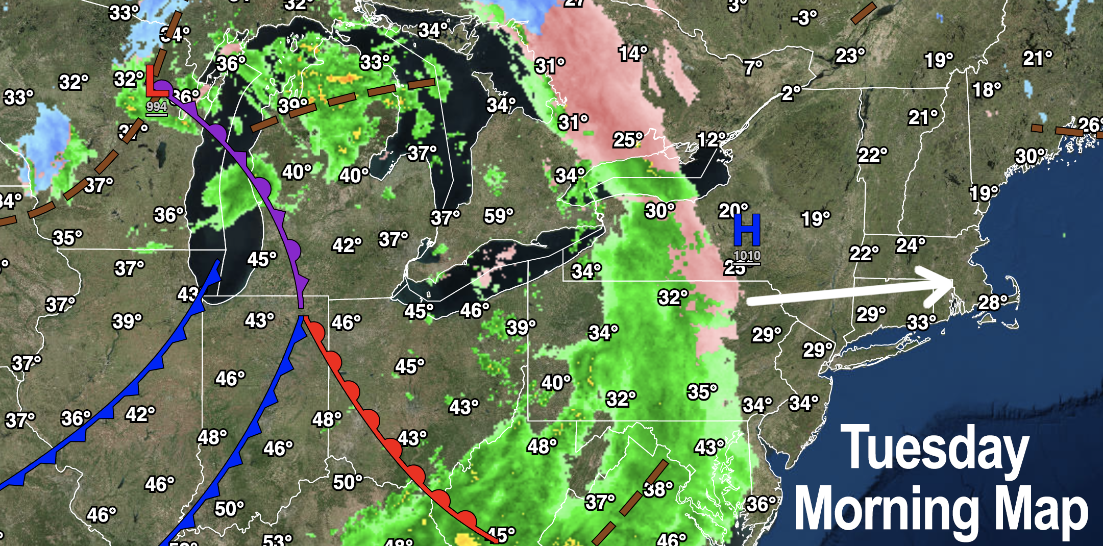
NATIONAL WEATHER SERVICE ALERTS
–Winter Weather Advisories for southern VT are up for later afternoon into early Wednesday morning for light icing
DHTWN REMINDER
–The odds of being a human are 1 in 400,000 billion… make it count, even in a small way (see Kurt Vonnegut quote at end of post)
DAILY CELESTIAL (STAR):
–OUR STAR ROSE AT: 7:15am this morning
–OUR STAR WILL SET AT: 4:45pm this evening
–TOTAL DAYLIGHT TIME: 9 hours and 30 minutes
NIGHTLY CELESTIAL (MOON):
–OUR MOON WILL SET AT: 12:26pm this afternoon
–OUR MOON WILL RISE AT: 4:05am tomorrow morning
–MOON SET DIRECTION: West-Southwest
–MOON RISE DIRECTION: Southeast
–MOON PHASE: Waning Crescent (25.3%)
———————-
DAILY TERRESTRIAL (ZoneCast)
ZONE 1 (Northern Region)
Southern VT, Southwest NH, N. Taconics NY
–High Temps: Upper 30s to Low 40s
–Low Temps: Low 30s
–Wind: Light west wind
–Skies: Sunny early, clouds build this afternoon
–Precipitation: Scattered rain showers arrive late this afternoon with areas of light sleet and freezing rain overnight which could cause some slippery travel
ZONE 2 (Central Region)
WMass, N. CMass, N. Litchfield County, C./S. Taconics NY
–High Temps: Upper 30s to Mid 40s
–Low Temps: Low 30s
–Wind: Light west wind
–Skies: Sunny early, clouds build this afternoon
–Precipitation: Scattered rain showers arrive late this afternoon with areas of light sleet and freezing rain overnight in the northern Berkshires and northwest hilltowns of Franklin/Hampshire Counties, some slippery travel possible
ZONE 3 (Southern Region)
S. CMass, S. Litchfield County, NC.CT, & NE.CT
–High Temps: Mid 40s
–Low Temps: Low to Mid 30s
–Wind: Light west wind
–Skies: Sunny early, clouds build this afternoon
–Precipitation: Scattered rain showers arrive late this afternoon ending by early Wednesday morning
———————-
WHERE’S DAVE?
1. I’ve been reporting our weather daily here and at https://www.westernmassweather.com for a decade
2. Get my free weekly newsletter here: https://westernmassweather.com/homepage/dhtwn-nutletter-signup/
3. Actively visit this FB page via the app or web, as I may not always auto-kiss your screens
———————-
MORNING DISCUSSION
Good morning everybody, we’ve got a lot of active weather with a variety of precipitation types over the next week with at least 4 storm and/or frontal systems working through the region, so instead of coffee I will be hooked to an IV with caffeine drip, so if there are any nurses in the house, I may require your services… baristas, too!!
For today, we start off with sunshine as brief high pressure works into the region, but it’s a tiny thin ribbon of drier air, and will be kicked out to sea and replaced with clouds and scattered rain showers by this evening with milder temps today reaching highs in the upper 30s to mid 40s.
For tonight, isolated to scattered showers are expected though there may be some lulls in the action.
Lows will be dropping into the low to mid 30s, and folks in far northwest MA and southern VT into southwest NH should see some light sleet or freezing rain with a light glaze possible.
This could cause slippery/icy travel by early Wednesday morning in SVT, hence the Winter Weather Advisories.
The front clears the region on Wednesday with partly sunny skies developing and a pretty nice day to look forward to, with highs in the upper 30s to mid 40s with lows in the upper 20s with mostly cloudy skies in place.
For Thursday and Friday, a complex storm system moves into the region. With high pressure north, colder air will be draining south into the region, but highs will still be above freezing, rising into the mid to upper 30s.
This means we should start as rain across much of the region by Thursday afternoon but as we head into the evening, areas along and north of the Rt. corridor in northern MA and up into southern VT and NH should start changing over to snow.
This could turn into a moderate-level snowstorm for those areas with some folks getting up to or over half a foot of snow, which would get the plows out on the roads, so stay tuned for updates.
Other refinements needed will be what transpires in the area of WMass, CMass and northern CT south of the Rt. 2 area, as there will be more of a mix of snow and rain, but light accumulations of say 1-4″ are possible there too, likely north of the CT line, but I will update you as we get closer.
In fact, we may all turn to snow on Friday as the storm pulls away and a lingering secondary disturbance pushes in as colder air arrives, though that looks to be a light snow day, not heavy.
The weekend looks lovely, with Saturday being the weekend pick with highs in the 30s both days (a bit milder Sunday) with clouds building and another storm with snow and rain pushing in Sunday night into Monday, and yet another storm possible next Wednesday!
Have a great day and stay tuned for updates!
Join my Free Weekly Nutletter.
AND REMEMBER…
“Hello babies. Welcome to Earth. It’s hot in the summer and cold in the winter. It’s round and wet and crowded. On the outside, babies, you’ve got a hundred years here. There’s only one rule that I know of, babies: Goddamn it, you’ve got to be kind.”
–Kurt Vonnegut