
TABLE OF CONTENTS
* Daily Celestials (Sun/Moon Data)
* Weekly Weather Nutshell
* Morning Discussion
* TIP: Scroll below for sections, or read all
~~~~~~~~~~~~~~~~~~~~~~
YOUR DAILY CELESTIALS
~~~~~~~~~~~~~~~~~~~~~~
STAR:
–OUR STAR WILL RISE AT: 7:15am this morning
–OUR STAR WILL SET AT: 4:44pm this evening
–TOTAL DAYLIGHT TIME: 9 hours and 29 minutes
MOON:
–OUR MOON WILL SET AT: 11:15pm tonight
–MOON SET DIRECTION: West
–OUR MOON WILL RISE AT: 10:51am tomorrow morning
–MOON RISE DIRECTION: East
–MOON PHASE: Waxing Crescent (31.5%)
~~~~~~~~~~~~~~~~~~~~~~
A NOTE FROM OUR SPONSOR
~~~~~~~~~~~~~~~~~~~~~~
Dave Hayes The Weather Nut is Sponsored by Individual Community Members, Patrons, and Tandem Bagel Company… No matter the weather, Tandem Bagel is always there for you at several valley locations to make your mornings brighter! With bagels baked fresh daily (including Gluten-Free options), house-whipped cream cheese, coffee, and tons of lunch options, Tandem is the perfect quick stop for lunch, breakfast, or a coffee and bagel to go. Find them in Easthampton, Northampton, Hadley, Florence, and West Springfield, or use their super-streamlined online ordering tool by visiting their website.
~~~~~~~~~~~~~~~~~~~~~~
YOUR WEEKLY WEATHER NUTSHELL
~~~~~~~~~~~~~~~~~~~~~~
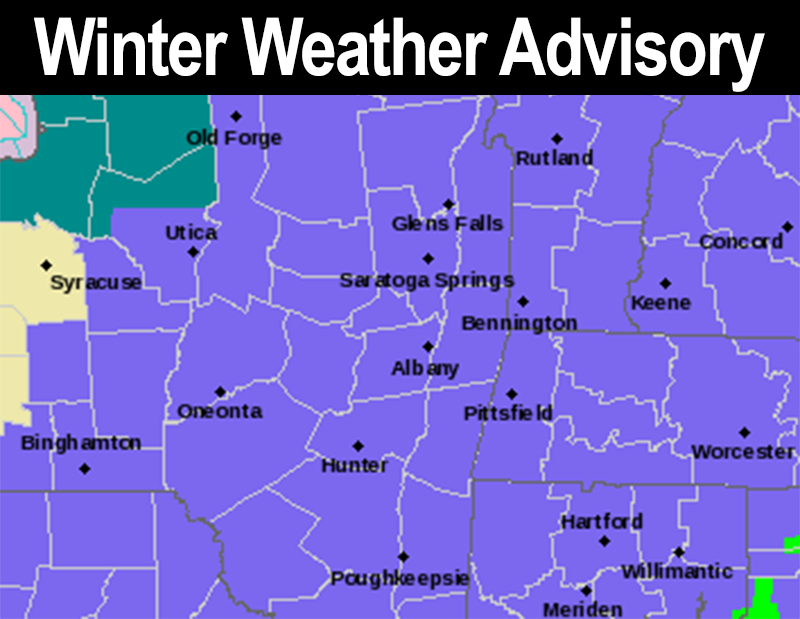
–Light to moderate snow today, with 2-5″ for most by evening
–Some icing should mix in to parts of northern CT, and as far north as the MassPike in MA from about Springfield to Worcester
–Icing has been introduced due to more northward track of the low center, which pushes milder air aloft further north
–Otherwise, the bulk of the region is all snow
–As an upper level feature tracks east snow becomes steadier this afternoon before ending around dinner timee
–Evening commute will be slick for some
–Highs mid 20s to low 30s, lows in the teens with northwest gusts up to 25mph, blustery and cold
–Wednesday and Thursday will see highs in the low to mid 20s and mid to upper 20s respectively, lows in the teens, and more sun on Wednesday than Thursday
–Clouds increase late Thursday as another system gathers off of the Mid-Atlantic coast
–Today’s system was also originally set to mostly go out to sea as is Friday’s system, but for now let’s say a light snow is forecast with adjustments to be made later in the week
–Super cold and fair weather this coming weekend with milder temps next week
~~~~~~~~~~~~~~~~~~~~~~
YOUR MORNING DISCUSSION
~~~~~~~~~~~~~~~~~~~~~~
Good morning everybody, our light to moderate snowstorm is underway with many reporting light snow this morning.
Snow will fall today, varying between light and moderate intensity, along with some brief lulls at times, especially during the morning.
As our upper level trough and an upper wave spinning off of it towards New England continues to track east, we should see it interact with the surface low tracking northeast off of the east coast and producing more atmospheric lift into the greater WMass region by late morning to early afternoon.
This should help snow become steadier for a time into the early to mid afternoon period, before it starts to slowly taper off late afternoon into early evening.
At the same time, with our surface low tracking and getting pulled closer to Cape Cod, some mild air aloft should nose up into parts of northern CT and even as far north as the Springfield to Worcester corridor along/south of the Pike with some sleet and/or freezing rain mixing in there this afternoon.
This would cut snow totals down to the lower part of the 2-5″ that is expected region-wide, and may cause slick travel.
There’s not real wind with anticipated with this system, and it looks like a few areas may see up to half a foot or so, but 2-5″ should do it for the vast majority of us in the greater WMass region.
Highs will reach the mid 20s to low 30s today, and then crash into the teens tonight as the storm lifts northeast and out of here with pretty quick clearing, and northwest wind gusts up to 25mph for a cold blustery night ahead.
Wednesday and Thursday feature fair, dry, and cold weather with highs in the low to mid 20s under sunny skies tomorrow, and highs in the mid to upper 20s on Thursday under partly sunny to mostly cloudy skies, with more clouds late in the day.
Lows will be cold in the low to mid teens Wednesday night and near 20º Thursday night.
For Friday I’ll be watching another coastal storm trying to make itself useful for once, potentially pulling a more northerly track than currently expected, as the atmosphere does have a type of “memory” at times, but for now just expect either a light snowfall or some snow showers with highs in the 20s.
Behind that system, we get a final shot of very cold air, with blustery conditions and highs only in the teens and 20s, with lows in the single digits and teens before a milder air mass kicks our regional chunk of the Arctic outta here.
We may even be talking about rain showers by mid week, so winter lovers: ENJOY TODAY!
I will update later, safe travels to all…
>>> BE KIND <<<
“Hello babies. Welcome to Earth. It’s hot in the summer and cold in the winter. It’s round and wet and crowded. On the outside, babies, you’ve got a hundred years here. There’s only one rule that I know of, babies: Goddamn it, you’ve got to be kind.”
–Kurt Vonnegut