
TABLE OF CONTENTS
* Daily Celestials (Sun/Moon Data)
* Weekly Weather Nutshell
* Morning Discussion
* TIP: Scroll below for sections, or read all
~~~~~~~~~~~~~~~~~~~~~~
YOUR DAILY CELESTIALS
~~~~~~~~~~~~~~~~~~~~~~
STAR:
–OUR STAR WILL RISE AT: 7:16am this morning
–OUR STAR WILL SET AT: 4:42pm this evening
–TOTAL DAYLIGHT TIME: 9 hours and 26 minutes
MOON:
–OUR MOON WILL SET AT: 8:44pm tonight
–MOON SET DIRECTION: West-Southwest
–OUR MOON WILL RISE AT: 10:06am tomorrow morning
–MOON RISE DIRECTION: East
–MOON PHASE: Waxing Crescent (12.9%)
~~~~~~~~~~~~~~~~~~~~~~
>>> A NOTE FROM OUR SPONSOR <<<
Dave Hayes The Weather Nut is Sponsored by Individual Community Members, Patrons, and Gerard, Ghazey & Bates, P.C. GGBPC is a Northampton-based law firm regarded as the voice of pragmatic and well-reasoned estate planning, elder law and tax guidance in Western Massachusetts. The firm specializes in estate planning law, and expertly handles other matters such as Elder Law, Tax Law, as well as Real Estate purchase, sales, and refinance transactions. Contact GGBPC today to see how they can help!
~~~~~~~~~~~~~~~~~~~~~~
YOUR WEEKLY WEATHER NUTSHELL
~~~~~~~~~~~~~~~~~~~~~~
–Incoming Arctic cold front this early afternoon
–Mostly sunny early, then clouds increase late morning into the afternoon
–Snow Squall Warnings are already up in western PA, and squalls are tracking east-northeast
–As the front approaches, squalls capable of putting down a coating to 2″ in a short period of time will speed into the greater WMass region
–Snow squalls are like strong to severe summertime thunderstorms
–Very heavy snow, whiteout conditions possible, flash freezing of road surfaces, drastically lowered visibility can all combine to set conditions for possible vehicular accidents
–Please be weather aware during the mid-day to afternoon period
–With this front and behind it, west-southwest winds will gust 30-50mph after a breezier late morning period
–Highs will only reach the low to mid 30s and then crash into the teens tonight
–West winds will slacken a bit, but still gust 20-30mph tonight and drop wind chills to either side of zero degrees!
–Monday is tranquil, cold, sunny and features highs in the 20s with lows in the teens
–Tuesday continues to look like a light to at best moderate snowfall, with most likely a 1-4″ type result of total fluff
–Wednesday and Thursday see high pressure moving in behind our ocean system, with even colder temps with highs in the low to mid 20s
–Another light to moderate snowfall is possible on Friday with a fair but cold weekend following
~~~~~~~~~~~~~~~~~~~~~~
YOUR MORNING DISCUSSION
~~~~~~~~~~~~~~~~~~~~~~
Good morning everybody, I’m gonna just jump right in and says that this coming week’s weather has a couple of minor to moderate wintry impacts looming, notably with accumulating fluffy snow on Tuesday and possibly again on Friday.
Both of these systems generally look to be light with 1-4″ type snow ranges (that’s how it looks as of this writing), and no real wind, or other craziness involved.
Aside from that, we’re cold Monday, Tuesday, Wednesday, Thursday, Friday and next week, with fair weeather days with sunshine Monday, Wednesday and Thursday.
Highs will mostly be in the 20s during the week, with lows in the teens. I will refine this as we go, but it’s pretty standard winter weather as our modified Arctic air mass arrives today, and it is today that I want to center this discussion around, as the most dynamic weather of the next 7 days happens today, and in isolated areas some strong impacts may develop, so let’s dive in.
SNOW SQUALLS & WIND
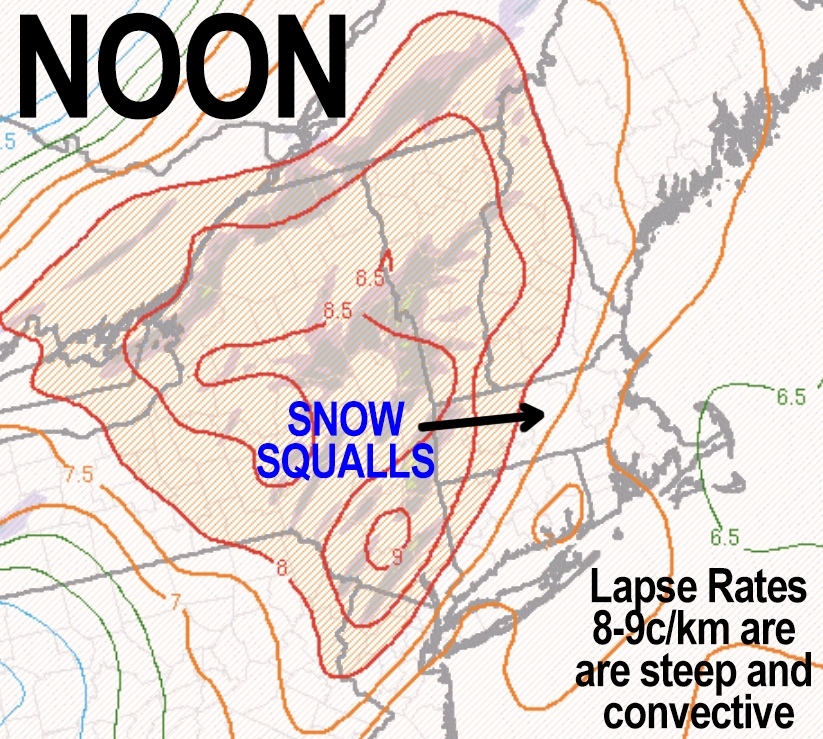
The upper trough connected to our most recent storm is centered over the Great Lakes, and our sharp and sassy little shortwave is rotating around its southeast flank and headed east-northeast for New England this afternoon.
This wave has punch and potency, and is working in with an Arctic cold front, that will provide plenty of forcing.
FORCING
What is forcing? Forcing just means that cold fronts, by their nature, act like a big scoop, and force air to rise skyward in front of them, as colder air is denser than milder air.
INSTABILITY
In addition, we will have strong low level instability moving into the region wtih MUCH colder air streaming in aloft, which creates buoyancy. Once air is forced to rise by the cold front, it keeps rising due to instability and steep lapse rates (which refers the gradient in temps from a milder surface to colder sky).
This wave, instability, forcing, and enough available moisture will coalesce into a band of heavier snow showeres and snow squalls, which are tiny little snowy tempests of heavy snow and wind that can (and likely, will today) put down a coating to 2″ of snow in half hour or less.
ROAD CONDITIONS
Now, not everyone will see a squall, some will just see run of the mill snow showers of varying intensity, some flurries, some possibly nothing, but like in the summer, those that get under the strong to severe cells could see whiteout conditions, drastically lowered visibility, and quickly changing road conditions due to heavy snow.
So, if you get caught driving in one of these, don’t be a hero. Take it easy, be alert to developing slippery travel and keep your awareness on other traffic.
Bad accidents can happen when these blow through, so just know that they will likely pass pretty quickly.
TIMING
These move through between 11am and 4pm from west to east today, so just keep an eye to the west and look for darkening skies, and you’ll know when they are approaching.
WIND
Along with the wind that can kick up within these squalls, the frontal passage will usher in strong westerly wind gusts of 30-50mph, which could cause isolated outages and produce blowing snow where a quick inch or two is put down.
While some wind may kick up ahead of this frontal passage, it will be most windy this afternoon and evening, slackening to 20-30mph gusts overnight with below zero wind chills possible.
UPSLOPE SNOW: ADDITIONAL ACCUMS.
Lastly, behind the frontal passage, upslope snow showers will develop over parts of the Berkshires, western hilltowns, Taconics and southern VT for additional snow accumulations, with up to 4″ total in some spots by tomorrow morning.
I will update late this morning toward mid-day as today’s weather approaches, given that we already have Snow Squall Warnings up in western PA and headed this way.
Stay tuned for updates and be weather aware this afternoon.
>>> BE KIND <<<
“Hello babies. Welcome to Earth. It’s hot in the summer and cold in the winter. It’s round and wet and crowded. On the outside, babies, you’ve got a hundred years here. There’s only one rule that I know of, babies: Goddamn it, you’ve got to be kind.”
–Kurt Vonnegut