
Snow this morning
DAILY REPORT CONTENTS
–Weekly Nutshell (Quick impact list)
–Sponsor Note (Tandem Bagel Co.)
–NWS Alerts (Advisories, Warnings, Watches)
–Celestial Data (Sun/Moon info)
–Terrestrial Data (Regional Summary Forecasts)
–Daily Discussion (Long-form explanation)
——————————-
DAVE’S WEEKLY WEATHER NUTSHELL
–Earl morning snizzle gives way to periods of snow showers overspreading the region between 8am-11am with a coating to 2″ by early afternoon (lower valley, higher hills)
–Precipitation lightens by afternoon as snow mixes with sleet, freezing rain along/north of Rt. 2, and rain south of Rt. 2, generally speaking, patchy fog possible as temps rise a bit
–Some icy travel expected north of Rt. 2 up into SVT and SWNH where Winter Weather Advisories are up, possible into northernmost MA, too
–Heavier rains develop tonight with SE winds gusting up to 35mph, thunder possible
–Rain lasts into Friday morning and quits by mid day, very mild
–Temps plummet Friday night into a seasonably cold and fair weekend, lasting into MLK Monday
–More showers Tuesday with a frontal passage, but no big whoop
–Above-average temps next week, with another Friday storm that may bring accumulating snow to some, but before we jump into the weather discussion/details below, let’s check a note from our local and delicious sponsor, #TandemBagelCo, with their newest location in West Springfield, MA.
——————–
A NOTE FROM OUR SPONSOR:
DHTWN Is Sponsored by Members, Patrons & Tandem Bagel Company: No matter the weather, Tandem Bagel is always there for you at several valley locations to make your mornings brighter! With bagels baked fresh daily (including Gluten-Free options), house-whipped cream cheese, coffee, and tons of lunch options, Tandem is the perfect quick stop for lunch, breakfast, or a coffee and bagel to go. Find them in Easthampton, Northampton, Hadley, Florence, and West Springfield, or use their super-streamlined online ordering tool by visiting their website.
——————————————-
***DHTWN DAILY WEATHER REPORT***
——————————————-
NATIONAL WEATHER SERVICE ALERTS
–Winter Weather Advisories are posted for southern VT and southwest NH
DHTWN REMINDER
–The odds of being a human is 1 in 400,000 billion… make it count, even in a small way (see Kurt Vonnegut quote at end of post)
DAILY CELESTIAL (STAR):
–OUR STAR ROSE AT: 7:17am this morning
–OUR STAR WILL SET AT: 4:40pm this evening
–TOTAL DAYLIGHT TIME: 9 hours and 23 minutes
NIGHTLY CELESTIAL (MOON):
–OUR MOON WILL RISE AT: 10:16pm tonight
–OUR MOON WILL SET AT: 10:46am tomorrow morning
–MOON RISE DIRECTION: East
–MOON SET DIRECTION: West
–MOON PHASE: Waning Gibbous (74.7%)
———————-
DAILY TERRESTRIAL (ZoneCast)
ZONE 1 (Northern Region)
Southern VT, Southwest NH, N. Taconics NY
–High Temps: Mid to Upper 30s
–Low Temps: Mid to Upper 30s (rising late at night)
–Wind: Light early, gusting 20-30mph out of the SE tonight
–Skies: Overcast
–Precipitation: Snow showers develop this morning, mix with sleet and freezing rain by afternoon, or freezing drizzle, changing to all rain tonight into Friday morning
ZONE 2 (Central Region)
WMass, N. CMass, N. Litchfield County, C./S. Taconics NY
–High Temps: Upper 30s to Mid 40s from north to south (some mid 30s in northwest MA possible)
–Low Temps: Upper 30s to Mid 40s (rising late at night)
–Wind: Light early, gusting 25-35mph out of the SE tonight
–Skies: Overcast
–Precipitation: Snow showers develop this morning, mix with sleet and freezing rain in the hills and plain rain in the valley by afternoon, changing to all rain tonight into Friday morning
ZONE 3 (Southern Region)
S. CMass, S. Litchfield County, NC.CT, & NE.CT
–High Temps: Upper 30s to Mid 40s
–Low Temps: Upper 30s to Mid 40s (rising late at night)
–Wind: Light early, gusting 25-35mph out of the SE tonight
–Skies: Overcast
–Precipitation: Snow showers develop this morning, mix with sleet and changing to all rain this afternoon and tonight into Friday morning
———————-
WHERE’S DAVE?
1. I’ve been reporting our weather daily here and at https://www.westernmassweather.com for a decade
2. Get my free weekly newsletter here: https://westernmassweather.com/homepage/dhtwn-nutletter-signup/
3. Actively visit this FB page via the app or web, as I may not always auto-kiss your screens
———————-
MORNING DISCUSSION
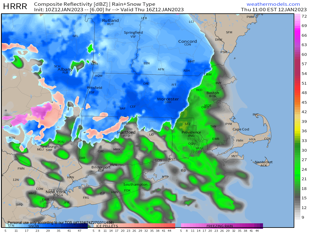
Good morning everybody, we have a storm that will track to our northwest tonight and tomorrow that is pushing two rounds of precipitation our way, and we start off round #1 with snow this morning.
It’s plenty cold at the surface and aloft to support snow this morning, but that will change with time by this afternoon as the precip shield lightens up.
Snow showers are moving into the LItchfields, Taconics and Berkshires and southwest VT already before 7am, and will continue to overspread the region west-southwest to east-northeast through the morning.
Varying intensities of snow will drop coatings in many areas of northern CT and WMass into CMass, with up to 1-2″ in far northern MA and SVT into SWNH by early afternoon.
The precip will lighten during the afternoon as round #1 exits and we change over to ice and rain around this time with temps warming a bit into the mid 30s north to mid 40s south in the greater WMass region.
Round #2 moves in tonight with the main part of the storm system, and it will rain heavily at times, with about 1-2″ of plain rain expected by Friday noon.
Low temps will hang near today’s highs and then rise overnight, and be in the 40s to low 50s tomorrow morning behind the warm front.
Patchy fog is also expected this afternoon, tonight and during Friday morning.
In addition, southeasterly to southerly winds will pickup and gust 25-35mph overnight and then switch around to the southwest by tomorrow later morning and afternoon as a cold front sweeps the region.
Highs are achieved Friday morning in the upper 40s to low 50s, and then temps will plummet into the mid 20s as we dry out in the afternoon and nighttime hours.
The weekend looks lovely and cold and sunny, with highs in the upper 20s to mid 30s Saturday and mid to upper 30s Sunday, and this nice weather should last into Monday as well with showers by Tuesday as temps rise into the low to mid 40s into the middle of next week.
Beyond that we have another storm system that looks to push into our region by next Friday and we may get some cold air in here prior to its arrival. If this system tracks our way and arrives at night, we could have a snow/ice to rain setup, so stay tuned and I will keep you updated, as there are some colder signals for late January into February.
Have a great day!
Join my Free Weekly Nutletter.
AND REMEMBER…
“Hello babies. Welcome to Earth. It’s hot in the summer and cold in the winter. It’s round and wet and crowded. On the outside, babies, you’ve got a hundred years here. There’s only one rule that I know of, babies: Goddamn it, you’ve got to be kind.”
–Kurt Vonnegut