
Thursday morning snow
–Really nice Wednesday ahead with seasonable cold, partly sunny on average, but clouds increase late in the day
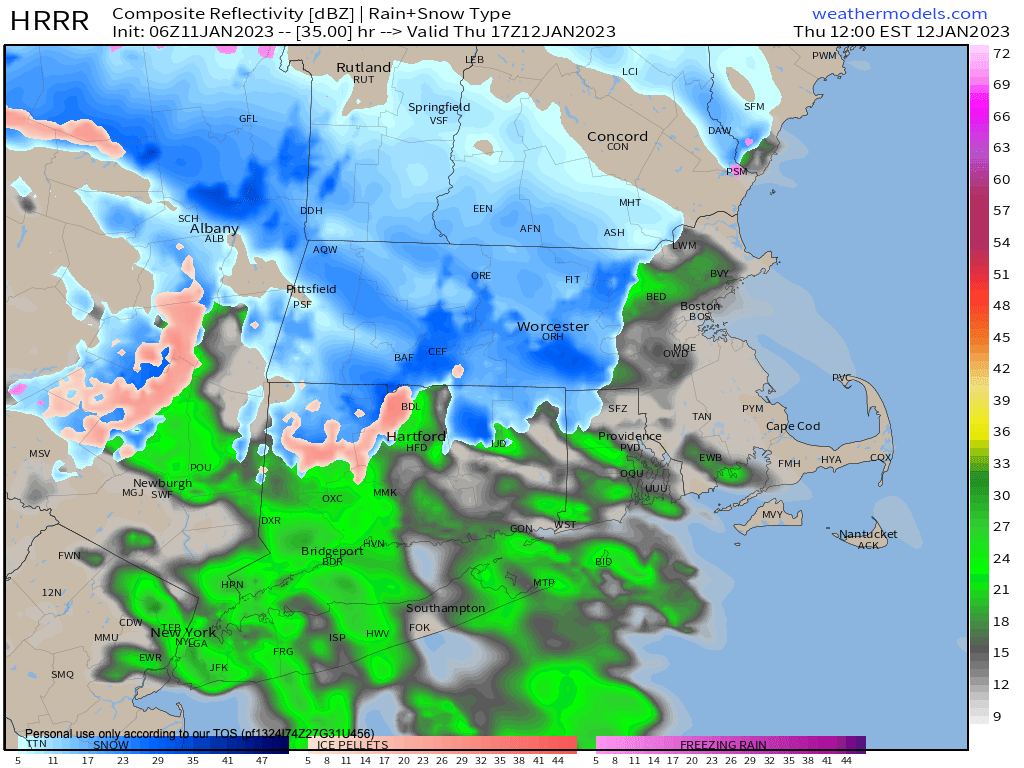
–Snow showers arrive with warm front Thursday morning, and a coating to an inch or two is expected before we change to rain by mid-day
–Snow or mixed precip may hang on in northern Berkshires, NW hilltowns and SVT into afternoon, but everybody is raining by Thursday night, heavy at times with gusty winds at elevation
–Thunderstorms possible as a squall line passes through after midnight, with showers ending later Friday morning, quite mild
–Cold front swings through and we’re back to seasonable cold and fair weather conditions this weekend, lasting into Monday
–A frontal boundary swings through connected to yet another storm that passes to our north, bringing showers on Tuesday or Tuesday night
–Next storm signal is a week from this Friday, and depending on track, it could bring a snow to rain setup, but before we jump into the weather discussion/details below, let’s check a note from our local and delicious sponsor, #TandemBagelCo, with their newest location in West Springfield, MA.
——————–
A NOTE FROM OUR SPONSOR:
DHTWN Is Sponsored by Members, Patrons & Tandem Bagel Company: No matter the weather, Tandem Bagel is always there for you at several valley locations to make your mornings brighter! With bagels baked fresh daily (including Gluten-Free options), house-whipped cream cheese, coffee, and tons of lunch options, Tandem is the perfect quick stop for lunch, breakfast, or a coffee and bagel to go. Find them in Easthampton, Northampton, Hadley, Florence, and West Springfield, or use their super-streamlined online ordering tool by visiting their website.
——————————————-
***DHTWN DAILY WEATHER REPORT***
——————————————-
NATIONAL WEATHER SERVICE ALERTS
–None
DHTWN REMINDER
–The odds of being a human is 1 in 400,000 billion… make it count, even in a small way (see Kurt Vonnegut quote at end of post)
DAILY CELESTIAL (STAR):
–OUR STAR ROSE AT: 7:17am this morning
–OUR STAR WILL SET AT: 4:39pm this evening
–TOTAL DAYLIGHT TIME: 9 hours and 22 minutes
NIGHTLY CELESTIAL (MOON):
–OUR MOON WILL RISE AT: 9:14pm this evening
–OUR MOON WILL SET AT: 10:47am tomorrow morning
–MOON RISE DIRECTION: East-Northeast
–MOON SET DIRECTION: West
–MOON PHASE: Waning Gibbous (82.5%)
———————-
DAILY TERRESTRIAL (ZoneCast)
ZONE 1 (Northern Region)
Southern VT, Southwest NH, N. Taconics NY
–High Temps: Low to Mid 30s
–Low Temps: Mid 20s
–Wind: Light and Variable
–Skies: Partly Sunny with clouds increasing late
–Precipitation: None
ZONE 2 (Central Region)
WMass, N. CMass, N. Litchfield County, C./S. Taconics NY
–High Temps: Mid to Upper 30s
–Low Temps: Mid to Upper 20s
–Wind: Light and Variable
–Skies: Partly Sunny with clouds increasing late
–Precipitation: None
ZONE 3 (Southern Region)
S. CMass, S. Litchfield County, NC.CT, & NE.CT
–High Temps: Mid to Upper 30s
–Low Temps: Mid to Upper 20s
–Wind: Light and Variable
–Skies: Partly Sunny with clouds increasing late
–Precipitation: None
———————-
MORNING DISCUSSION
Good morning everybody, our snowless pattern continues. Well, not entirely snowless, but just about entirely snowless, as we will see some Thursday morning light to moderate snow before changing to a solid rainfall Thursday night into Friday.
For today, we’ll have a mix of clouds and sun again, so partly sunny on average across the greater WMass region, with clouds increasing late in advance of our incoming warm frontal boundary.
Highs will be cold but tolerable, cresting into the low to mid 30s mostly, with some upper 30s along and south of the Pike down into northern CT. Wind will be light and variable, but end up light and out of the southeast.
Clouds increase tonight with lows in the mid to upper 20s with a few flurries possible by dawn on Thursday morning.
For tomorrow morning, snow showers increase, and we should see a fairly steady period of light snow to perhaps moderate briefly, which is expected to coat the ground, and accumulate up to an inch or two at most before mixing with and changing to rain by late morning along and south of the Pike and by early afternoon just about everywhere.
It is possible that the NW hilltowns of WMass, northern Berkshires and SVT could linger with mixed precipitation into the afternoon. Highs will climb into the 35-40º range.
Thursday night the rain will fall heavily at times, and we could even have a thunderstorm or two overnight (around or after midnight). Southwest winds will gust 25-40mph at elevation, but unsure if that makes it the ground over the Pioneer Valley, likely not. Lows will be in the 30s above freezing.
For Friday morning, rain will fall and then end by late morning with highs reaching the 45-50º range. The cold front sweeps through out of the southwest, with gusts from that direction 20-30mph in the afternoon, with some sunny breaks possible as the dry slot swings into the region.
Despite some high elevation flurries, we should see just mostly cloudy skies Friday night with lows in the mid to upper 20s with clearing late, setting us up for a gorgeous weekend.
While Sunday is the pick of the weekend with mostly sunny skies, both days will have some sun in the forecast with highs in the low to mid 30s and lows in the teens to low 20s as we sit back down to seasonable conditions.
Similar weather should extend through Monday, and then a weak frontal boundary may bring some light rain showers around Tuesday followed by more fair weather until next Friday.
There is another storm signal for that time period, and this time the track may run over us or just south of us, and that introduces the potential for a bit more wintry precipitation, so stay tuned for updates, folks!
Have a great day!
Join my Free Weekly Nutletter.
AND REMEMBER…
“Hello babies. Welcome to Earth. It’s hot in the summer and cold in the winter. It’s round and wet and crowded. On the outside, babies, you’ve got a hundred years here. There’s only one rule that I know of, babies: Goddamn it, you’ve got to be kind.”
–Kurt Vonnegut