
DAVE’S WEEKLY WEATHER NUTSHELL
–Cloudy start this morning, northwest breezes today, with periods of sun, early Berkshire flurry possible
–Quite cold tonight if radiational cooling gets the clearing it needs to maximize, some lows near 10º in NW.MA / SVT
–Fair Wednesday, seasonable, highs 30s
–Clouds Wednesday night, with snow showers by Thursday morning
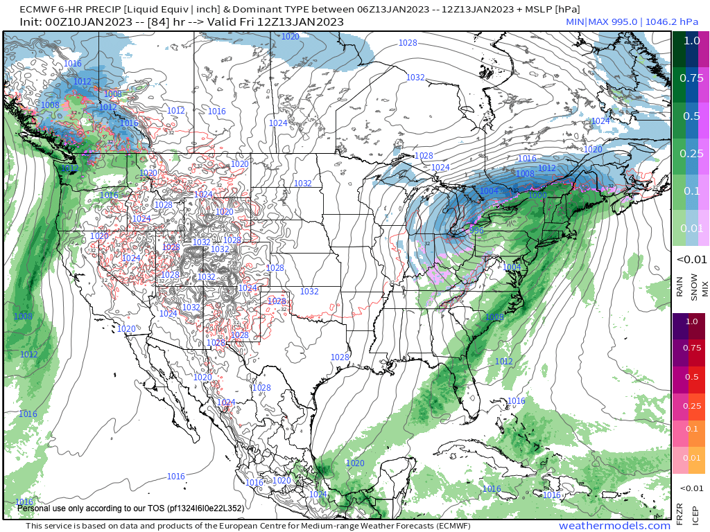
–Maybe some light accumulation, but it is short-lived as any snow flips to rain Thursday afternoon and evening as mild air invades, steadier/heavier rain Thurs. night into Friday noon
–Mild Friday, drying by afternoon, cold front comes through
–Secondary coastal storm may bring some back-end snow and rain showers, but will update as we get closer, no big whoop
–Sunday is the weekend pick, seasonably cool, fair weather lasts into early next week with more mild showers possible by mid week, but before we jump into the weather discussion/details below, let’s check a note from our local and delicious sponsor, #TandemBagelCo, with their newest location in West Springfield, MA.
——————–
A NOTE FROM OUR SPONSOR:
DHTWN Is Sponsored by Members, Patrons & Tandem Bagel Company: No matter the weather, Tandem Bagel is always there for you at several valley locations to make your mornings brighter! With bagels baked fresh daily (including Gluten-Free options), house-whipped cream cheese, coffee, and tons of lunch options, Tandem is the perfect quick stop for lunch, breakfast, or a coffee and bagel to go. Find them in Easthampton, Northampton, Hadley, Florence, and West Springfield, or use their super-streamlined online ordering tool by visiting their website.
——————————————-
***DHTWN DAILY WEATHER REPORT***
——————————————-
NATIONAL WEATHER SERVICE ALERTS
–None
DHTWN REMINDER
–The odds of being a human is 1 in 400,000 billion… make it count, even in a small way (see Kurt Vonnegut quote at end of post)
DAILY CELESTIAL (STAR):
–OUR STAR ROSE AT: 7:17am this morning
–OUR STAR WILL SET AT: 4:37pm this evening
–TOTAL DAYLIGHT TIME: 9 hours and 20 minutes
NIGHTLY CELESTIAL (MOON):
–OUR MOON WILL RISE AT: 8:11pm this evening
–OUR MOON WILL SET AT: 10:06am tomorrow morning
–MOON RISE DIRECTION: East-Northeast
–MOON SET DIRECTION: West-Northwest
–MOON PHASE: Waning Gibbous (89.1%)
———————-
DAILY TERRESTRIAL (ZoneCast)
ZONE 1 (Northern Region)
Southern VT, Southwest NH, N. Taconics NY
–High Temps: Upper 20s to Mid 30s
–Low Temps: Upper Singles to Mid 10s
–Wind: Northwesterly gusts to 10-20mph possible
–Skies: Mix of sun and clouds today, cloudy early
–Precipitation: Flurry possible early, then dry
ZONE 2 (Central Region)
WMass, N. CMass, N. Litchfield County, C./S. Taconics NY
–High Temps: Mid to Upper 30s
–Low Temps: Teens
–Wind: Northwesterly gusts to 10-20mph possible
–Skies: Mix of sun and clouds today, cloudy early
–Precipitation: Berkshire flurry possible early, then dry
ZONE 3 (Southern Region)
S. CMass, S. Litchfield County, NC.CT, & NE.CT
–High Temps: Mid to Upper 30s
–Low Temps: Upper 10s to Low 20s
–Wind: Northwesterly gusts to 10-20mph possible
–Skies: Mix of sun and clouds today, cloudy early
–Precipitation: None
———————-
MORNING DISCUSSION
Good morning everybody, we are continuing likely for the next two weeks in this milder, Pacific flow pattern where Arctic air is locked up over the Arctic and has spilled down into Siberia and northern Russia for the time being.
So while some periods of snow showers are possible in the fluctuation from seasonable to above-seasonable temperatures, we are generally going to see a series of inside runners/cutters, which are storms that pass to our northwest and given their counterclockwise circulation will pull milder air northward and into southern New England from the Mid-Atlantic and Southeast U.S. and western Atlantic Ocean source regions.
This means that we could start as snow, like I expect for the first half of Thursday, but then we flip to rain as milder air overwhelms the region from surface to sky. This will take place this Thursday/Friday, and likely again by the middle of next week, so that’s the pattern we’re stuck in.
For today, stubborn clouds have persisted overnight, and so we’ll start off cloudy with fairly mild temps in the low to mid 30s, but as a cold front comes through later, those will plummet tonight for the coldest night in a quite a bit.
So, a mixed sky today with clouds early and some periods of sun as well with highs mainly in the 30s (colder north, milder south), with radiational cooling potentially maximizing tonight with lows in the teens, and maybe some upper singles in SVT!
For Wednesday, we’ll start off on the sunny side and see highs rise into the low to mid 30s, but clouds will increase later on and into the evening with a few snow showers possible after midnight and into early Thursday morning with lows in the 20s.
Morning snow showers on Thursday may coat the ground in places, but milder air will be lifting into the region behind a warm front so snow flips to rain by afternoon, and becomes steadier and heavier into the night and ending Friday morning, or as late as noon.
Highs Thursday climb into the low to mid 40s Thursday with lows in the mid 30s, and highs on Friday in the mid to upper 40s before another cold front moves through the region and cools us down for the weekend.
Rain should quit by mid-day Friday, but then we have to watch a trailing wave for Friday night and Saturday which may bring some snow or rain showers on the back end.
So right now, Saturday is a big wild card as to how long inclement weather may persist, if at all, so stay tuned for updates, and know that the Sunday into Monday period looks lovely, and more seasonable with partly to mostly sunny skies and highs in the mid to upper 30s from north to south.
Have a great day!
Join my Free Weekly Nutletter.
AND REMEMBER…
“Hello babies. Welcome to Earth. It’s hot in the summer and cold in the winter. It’s round and wet and crowded. On the outside, babies, you’ve got a hundred years here. There’s only one rule that I know of, babies: Goddamn it, you’ve got to be kind.”
–Kurt Vonnegut