WEEKLY WEATHER NUTSHELL
We have fair weather for today and tomorrow followed by increasing clouds with warm frontal rains Tuesday afternoon and night followed by rain showers and warm Wednesday temps with showers, and then colder temps Thursday into Friday with potential for snow, but before we dive into all of the weather details below, let’s check a note from our new local weekend sponsor, #CranberryHillHealingArts located in Amherst, MA.
——————–
A NOTE FROM OUR WEEKEND SPONSOR:
DHTWN is sponsored by members, patrons, and Cranberry Hill Healing Arts. The turning of the seasons can be challenging, and Carolyn Walker of Cranberry Hill Healing Arts in Amherst is there for you. When you are searching for ways to be at peace, seek relaxation, and feel more energetic, let Reiki & Sound Healing guide you on your journey to wholeness. Through energy work and the gentle vibrations of singing bowls, chimes, and chanting, Carolyn crafts a safe and calming space to experience renewal. Learn more and/or book your session today by visiting her website.
——————————————-
***DHTWN DAILY WEATHER REPORT***
——————————————-
Good morning everybody, I am wishing you a heartfelt Happy New Year today, and hope you had an enjoyable, fun, peaceful, quiet, relaxed, or raucous New Year’s Eve.
I spent the afternoon with my sweetie and two wonderful friends attending First Night Northampton festivities and saw the pirate-y and talented Snackbeard, my beloved super-friendly and talented friend Ray Mason, and the lush silver tones of the Happy Valley Guitar Orchestra, all of which were fabulous.
During my town-centered traipses, I donned no rain gear: no rain coat, no umbrella, no galoshes, no vinyl-coated rain hat, nothing – I got soaked! This is the thing with me… I never listen to my own advice, HA!!!
I reasoned last night that that’s because I need to FEEEEEL the weather, I need to merge with it, absorb its effects, interface my face with the hydrometeors, so I can feel ALIVE.
Yes, I know I’m a weirdo, but I’m a benevolent weirdo. I also am happy that evaporation is a thing, and know I’ll dry off eventually, lol.
One time about 10 years ago or so I took a break from my job in Hatfield and walked WAY out into a heavy wet storm in a field for my lunch break and just got dumped on with wet snow. I came back and was so completely soaked I had to run home and change my clothes, luckily I had a cool boss who made room for such whackery.
Anyway, enough about me, let’s talk about you and move onward to the weather!
We’ve got a departing cold front, but very mild temps still behind it, so we’re basically experiencing our high temps this morning, as they should fall through the 40s during the afternoon, and land in the low 30s overnight.
We’ll partly sunny skies on average, with more sun in the valley, and more clouds in the high terrain, and west winds behind the front will gust up to 25mph or so at times today, and then slacken/weaken tonight.
For Monday, another partly sunny day is on the way as we’ll still be under the influence of an east coast ridge that will shunt the mid-week storm track north of the WMass region, keeping us in a mild flow into Thursday morning.
Highs Monday will be in the 45-50º range, with lows in the low 30s once again.
On Tuesday, we cloud up as a warm front floats toward the region, and highs will climb above 50º. Showers will arrive by mid to late afternoon, and we could see some pretty decent rains overnight Tuesday into Wednesday.
Once the warm front passes through, we’ll see temps climb Wednesday into the 55-60º range with a showery day expected at this point, lasting into Wednesday night.
I will refine impacts as we get closer, but Tuesday afternoon through Wednesday generally looks quite wet.
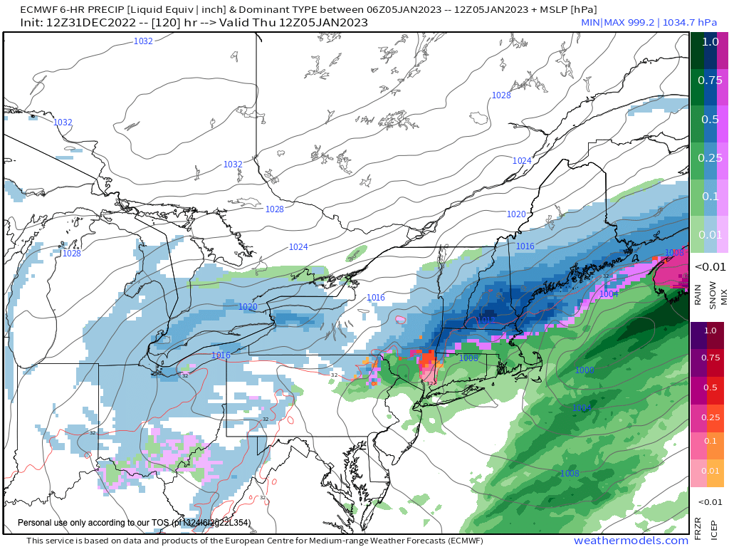
Now, we will be seeing a cold front dropping north to south Wednesday night into Thursday in combination with high pressure to our northeast, and a coastal low that will try to get its act together to our southeast.
This will produce northeasterly flow into the region, and we could see rain changing to snow Wednesday night into Thursday with some light accumulations possible.
Thursday looks much colder, with highs only in the 30s to near 40º, and at this point, the high terrain has the best chance for seeing wet snow that sticks, so stay tuned for updates.
Friday and Saturday we return to fair weather, but seasonable conditions with highs in the 30s and lows in the 20s, so if you like mild weather, enjoy it now, because it’s going away.
There are signals that we remain in a seasonable winter pattern into the second week of January, so even though time will tell, our January thaw may have come early this year.
We shall see how life unfolds as we put one foot in front of the other.
Have a great day and Happy New Year once again, I am so grateful for your readership and support, you folks are the best weather community on Earth, thank you from the bottom of my heart! <3 You can also follow me on Twitter.
AND REMEMBER…
“Hello babies. Welcome to Earth. It’s hot in the summer and cold in the winter. It’s round and wet and crowded. On the outside, babies, you’ve got a hundred years here. There’s only one rule that I know of, babies: Goddamn it, you’ve got to be kind.”
–Kurt Vonnegut
