
TABLE OF CONTENTS
* Daily Celestials (Sun/Moon Data)
* Sponsor Note
* Join My Newsletter
(& get my Top12WMassStorms ebook!)
* Morning Discussion
* TIP: Scroll below for sections, or read all
~~~~~~~~~~~~~~~~~~~~~~
YOUR DAILY CELESTIALS
~~~~~~~~~~~~~~~~~~~~~~
STAR:
–OUR STAR ROSE AT: 5:52am this morning
–OUR STAR WILL SET AT: 7:58pm this evening
–TOTAL DAYLIGHT TIME: 14 hours and 6 minutes
MOON:
–OUR MOON WILL SET AT: 10:13pm tonight
–MOON SET DIRECTION: West-Southwest
–OUR MOON WILL RISE AT: 11:52am tomorrow morning
–MOON RISE DIRECTION: East-Southeast
–MOON PHASE: Waxing Crescent (21.5%)
~~~~~~~~~~~~~~~~~~~~~~
A NOTE FROM OUR SPONSOR
~~~~~~~~~~~~~~~~~~~~~~
Dave Hayes The Weather Nut is Sponsored by Individual Community Members, Patrons, and Tandem Bagel Company… No matter the weather, Tandem Bagel is always there for you at several valley locations to make your mornings brighter! With *New Pizza Bagels(!)*, along with bagels baked fresh daily (including Gluten-Free options), house-whipped cream cheese, coffee, and tons of lunch options, Tandem is the perfect quick stop for lunch, breakfast, or a coffee and bagel to go.
You can either 1) visit them in Easthampton, Northampton, Hadley, Florence, and/or West Springfield, 2) hire them to cater your next event, or 3) use their super-streamlined online ordering tool by visiting their website and clicking the “Catering” or “Order Online” links.
~~~~~~~~~~~~~~~~~~~~~~
DAVE’S WEEKLY NEWSLETTER (Top 12 WMass Storms)
DAVE’S MOBILE APP (Late 2024 Release)
~~~~~~~~~~~~~~~~~~~~~~
YOUR MORNING DISCUSSION
~~~~~~~~~~~~~~~~~~~~~~
Good morning folks, well, we have one more 24 hour period of inclement, summer weather to get through before we can break on through to the other side, as Jim Morrison once bellowed from his belligerent belly.
Patchy fog burns off with time today, but there’s something I need to expand on this morning.
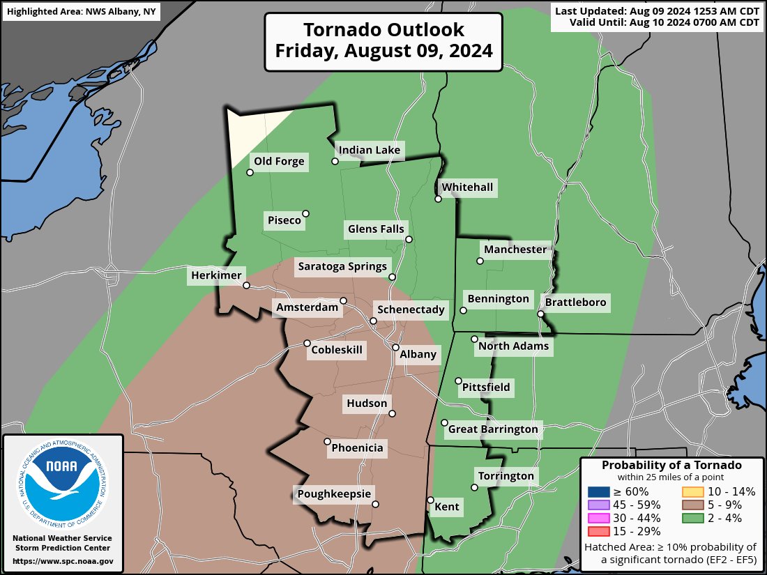
I need to start off this report by stating that we have a weak, transient tornado threat tonight, highest in the Berkshires and Litchfield County CT.
It’s a low risk as Debby’s remnant low slowly falls apart, and slowly weakens as it tracks towards Plattsburgh, NY tonight.
Having said that, tropical systems create lots of macro-level spin (a/k/a vorticity) AND low-level spin (a/k/a helicity).
This tends to produce, on average, weaker type and sometimes quick-to-dissipate “spin-ups” or tornadoes in feeder rain bands on the east and southeast flanks of such tropical systems.
Because such tornadoes can spin up and dissipate so quickly, they are not always able to be detected on radar fast enough to get Tornado Warnings issued on them by the NWS, especially here in WMass as we are farther away from the main radar beams (remember the Conway Tornado was not a tornado-warned storm… and to be clear, I don’t expect any tornado that MAY form to be that strong, should be weaker EF-0s if they do form).
All this to say, that anywhere between 4pm and Midnight (and mostly 6-11pm), I will do my best to make you aware of potential transient spin-ups here and the other space that most people don’t like, but that I use because I can get my info out to people.
However, you will need to develop some personal awareness of local changes in wind flow at your home, and also LISTEN for changes in sound, as these types of spin ups can just whip through in 5-10 seconds, be gone as fast as they came, and are very small in size. They’re almost like glorified dust devils in some cases, capable of real damage as mischief makers.
Again, 99.9% of people likely see nothing, or experience any issues with wind beyond the southerly gusts up to 40mph in spots, especially the high terrain, but I just wanted to educate on these types of setups.
I doubt a Tornado Watch will expand into our region.
Going forward, highs will reach the mid to upper 70s today, and dewpoints will surge from the 60s to 70s by this evening, so tropical air is on the way, and it will be mostly cloudy.
Scattered showers or a downpour, or mist, possible at any point today witiih dry/lull periods, but by 4pm through the night, showers, downpours, a few thunderstorms are expected, with a weak tornado or two possible, most likely WEST of the I-91 corridor.
Lows tonight dip into the 65-70º range with patchy fog possible as we start to dry out by morning.
Essentially, we’ve got a 5-day stretch of partly to mostly sunny skies with highs in the 70s and lows in the 50s, starting Saturday late morning into afternoon through middle of next week, with much drier air, and a total air mass change.
There are more tropical signals for early the following week, and we may see a shower Monday, but I will update you on all of that tomorrow morning.
For now, I am firmly focused on today and tonight, so I will keep updating on social media as needed.
Thanks and have a great day.
“Follow your bliss and the universe will open doors for you where there were only walls.”
― Joseph Campbell