
TABLE OF CONTENTS
* Daily Celestials (Sun/Moon Data)
* Sponsor Note
* Join My Newsletter
(& get my Top12WMassStorms ebook!)
* Morning Discussion
* TIP: Scroll below for sections, or read all
~~~~~~~~~~~~~~~~~~~~~~
YOUR DAILY CELESTIALS
~~~~~~~~~~~~~~~~~~~~~~
STAR:
–OUR STAR ROSE AT: 5:59am this morning
–OUR STAR WILL SET AT: 7:48pm this evening
–TOTAL DAYLIGHT TIME: 13 hours and 49 minutes
MOON:
–OUR MOON WILL RISE AT: 6:13pm this evening
–MOON RISE DIRECTION: Southeast
–OUR MOON WILL SET AT: 2:51am tomorrow morning
–MOON SET DIRECTION: Southwest
–MOON PHASE: Waxing Gibbous (85.6%)
~~~~~~~~~~~~~~~~~~~~~~
A NOTE FROM OUR SPONSOR
~~~~~~~~~~~~~~~~~~~~~~
Dave Hayes The Weather Nut is Sponsored by Individual Community Members, Patrons, and Tandem Bagel Company… No matter the weather, Tandem Bagel is always there for you at several valley locations to make your mornings brighter! With *New Pizza Bagels(!)*, along with bagels baked fresh daily (including Gluten-Free options), house-whipped cream cheese, coffee, and tons of lunch options, Tandem is the perfect quick stop for lunch, breakfast, or a coffee and bagel to go.
You can either 1) visit them in Easthampton, Northampton, Hadley, Florence, and/or West Springfield, 2) hire them to cater your next event, or 3) use their super-streamlined online ordering tool by visiting their website and clicking the “Catering” or “Order Online” links.
~~~~~~~~~~~~~~~~~~~~~~
DAVE’S WEEKLY NEWSLETTER (Top 12 WMass Storms)
DAVE’S MOBILE APP (Late 2024 Release)
~~~~~~~~~~~~~~~~~~~~~~
YOUR MORNING DISCUSSION
~~~~~~~~~~~~~~~~~~~~~~
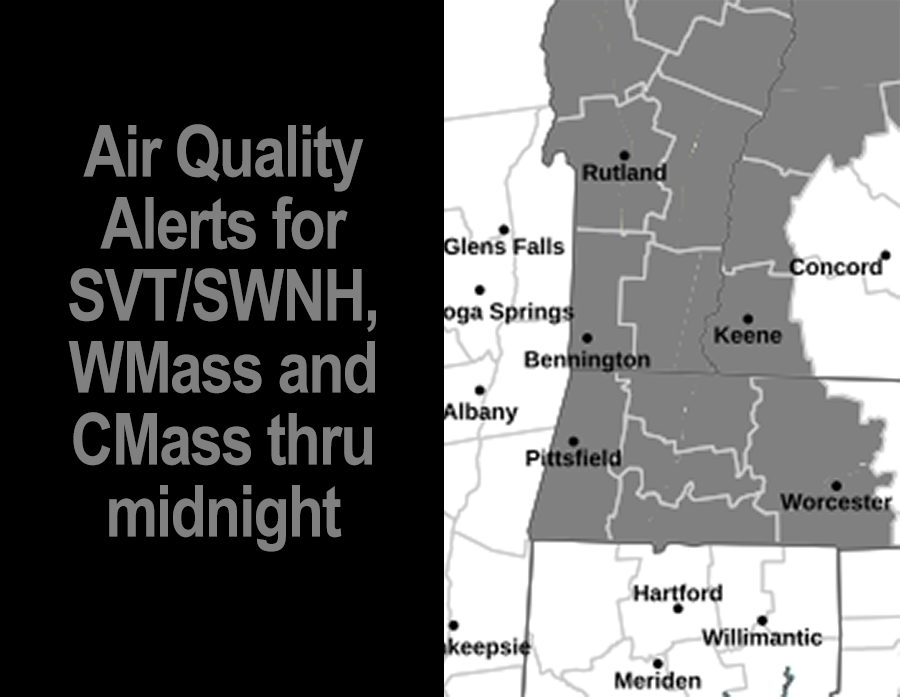
Good morning everybody, we’ve got a wildfire smoke plume moving through the region today from the western Canadian wildfires that was directed south and into our region thanks to an upper low that is already further east and into Atlantic Canada. It may linger a bit tomorrow too, but I believe today is the worst of it and Air Quality Alerts are up region-wide because of it, so take it easy.
Temps are starting off in the low 60s or so with patchy dense fog in spots, notably in Keene which reported a sub-tenth of a mile visibility earlier this morning, so take it slow where fog has formed.
This will burn off, and reveal a partly to mostly sunny but very hazy day today with fairly poor air quality, and highs well into the 80s, with some upper 80s possible in the southern Pioneer Valley.
This will be the warmest day we see in at least the next 7, and we will also see a few hilltown showers or a thunderstorm form, but with high pressure moving in the valley should stay mostly dry.
Humidity continues to slowly creep up today through the weekend, peaking on Monday.
Lows tonight will dip into the low to mid 60s with patchy fog possible late.
I will be watching a cold front associated with an upper low that today is pushing into the western Great Lakes region slowly track east toward and through New England from Saturday through Monday night, exiting to the east by Tuesday morning.
Because of the front’s slow passage to high pressure to our west Saturday slowing down as Ernesto tracks NNE towards Newfoundland slowing IT down, Saturday should be partly sunny and mostly dry earlier on with a few scattered showers at times in the afternoon or evening.
Highs Saturday will reach the upper 70s to low 80s, with lows in the low to mid 60s, and it will be fairly humid.
By Sunday, the morning looks fairly dry with a few showers possible, and highs will only reach the mid to upper 70s under mostly cloudy skies. Lows will be in the 60s as humidity increases along with patchy fog.
By afternoon, the front or a pair of fronts will be approaching, and rain should increase in coverage Sunday afternoon and evening through the night into Monday and Monday night. It won’t rain ALL the time, but expect periods of rain of varying intensity, with some heavy rain and a few thunderstorms as well.
Highs Monday reach the 70s and it will a wet day as the cold front focuses rain across the region. Lows will be in the 60s as showers start to wind down late.
By Tuesday any lingering early morning showers will pull east with the front, and another episode of everybody’s favorite TV show “The Whooshening!” will play across the sky screen, with lowering humidity, dewpoints in the 50s, and cooler air sweeps into the the WMass region by Tuesday night with highs in the upper 60s to mid 70s, and lows Tuesday night in the upper 40s to low 50s, a bit chilly!
Wednesday into Thursday looks to feature fair weather, high pressure building in from the west, sunshine and highs in the upper 60s to mid 70s.
Have a great day!
“Follow your bliss and the universe will open doors for you where there were only walls.”
― Joseph Campbell