
SECURELY BECOME A 2025
WEATHER NUT SUPPORTER TODAY
–> When 4% of readers support at any level,
this community weather resource remains active:
(Secure options include Cards, PayPal, Venmo, Check)
~~~~~~~~~~~~~~~~~~
TABLE OF CONTENTS
* Daily Celestials (Sun/Moon Data)
* Sponsor Section
* Morning Discussion
* TIP: Scroll to your section, or read all
~~~~~~~~~~~~~~~~~~~~~~
YOUR DAILY CELESTIALS
~~~~~~~~~~~~~~~~~~~~~~
STAR:
–OUR STAR ROSE AT: 6:53am this morning
–OUR STAR SETS AT: 5:15pm this evening
–TOTAL DAYLIGHT TIME: 10 hours and 22 minutes
MOON:
–OUR MOON RISES AT: 2:01pm this afternoon
–MOON RISE DIRECTION: Northeast
–OUR MOON SETS AT: 6:06am tomorrow morning
–MOON SET DIRECTION: Northwest
–MOON PHASE: Waxing Gibbous (90.0%)
~~~~~~~~~~~~~~~~~~~~~~
>>> A NOTE FROM OUR WEEKEND SPONSOR <<<
Dave Hayes The Weather Nut is Sponsored by Individual Community Members, Patrons, and Gerard, Ghazey & Bates, P.C.
GGBPC is a Northampton-based law firm and is the area’s premier estate and tax planning provider. The firm specializes in Estate Planning, Elder Law, and Tax Law, so be sure to contact GGBPC today to see how they can help you.
Simply click the this link to their secure website.
~~~~~~~~~~~~~~~~~~~~~~
YOUR MORNING DISCUSSION
~~~~~~~~~~~~~~~~~~~~~~
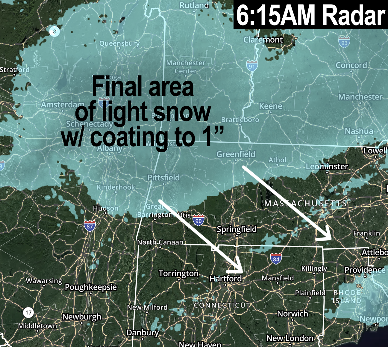
Good morning folks, we have back-end / wraparound snow moving southeast through the region that are adding additional light accumulation before the storm winds down toward mid-day.
If you read my 9:30pm “bust” report last night, you saw that I pulled totals down given what I’ve realized will be my new non-catchy, too-many-syllabled phrase:
The Four Horsemen of Busted Snowstorms
(TFHOBS, which is much easier to remember, like WMSLTOD)
They are:
1. Initial longer-standing virga
(evaporating snow during storm’s onset)
2. Dry air punches at any level
(usually during back half of storm duration)
3. Storms that produce convection / thunderstorms
(These can pull energy away from us or poke holes in the precip shield)
4. Subsidence between banding
(What goes up, must come down. Rising air creates heavy snow in Greenfield, and subsident / sinking air aside that heavy band makes it light in Hamp, for example)
All of those processed occurred last night.
I’m not making an excuse, I’m just trying to explain what happened that I didn’t foresee happening in tandem, or to the degree those processes did.
I used to beat myself up mercilessly over busted snowstorm forecasts, and many of you remember those posts years back.
I’m not doing that anymore, but do I feel horribly when this happens?
Yes, of course I do, because I know businesses and families look to accurate forecast information from me for planning, and I take what I do very seriously, so let’s just say today isn’t going to be Dave’s brightest and best…… but in the end we still got some snow, it looks pretty and wintry, no one got hurt from a few less inches of snow, the plows still came out mostly, and their equipment didn’t get beat up on as much than it would have with twice the snow, so onward we go.
For today, we have a final wraparound band of snow that is tracking southeast through WMass and laying down additional light accumulations on top of what fell overnight. In addition, it is a signal that it’s getting colder aloft from north to south, and replacing the freezing drizzle/fog or other icing that formed in the middle of the night and crusted over the snow that did fall.
Watch for slippery surfaces this morning due to any freezing drizzle, or light freezing rain, as well as from this final, back-end light (to at times moderate) snow band moving through. An additional coating to 2” or so is possible and should (for most) put us into the range I offered last night (3-6” south of Route 2, and 5-10” along and north in MA, SVT and SWNH, though I some places will fall short of those low ends of the range given what transpired last night).
Highs today will reach the upper 20s to mid 30s under mostly cloudy skies with some sunny breaks possible later this afternoon, with lows in the teens overnight under partly cloudy skies.
Aside from some light snow showers south of the Pike Tuesday night from a system sliding south of us and out to sea, I think the Monday through Wednesday timeframe will feature cold but mostly fair weather conditions with highs in the mid 20s to low 30s, and lows in the single digits to low teens.
Monday and Wednesday should feature partly to mostly sunny skies with more clouds on Tuesday as that system passes close to us to our south.
By Wednesday night clouds will build, and another storm system is expected to push northeast into New England with wintry precipitation.
A primary low pressure system probably tracks over NY to our west, but if a secondary can form and help keep colder air in place, we’d likely see accumulating snow changing over to sleet and freezing rain late Wednesday night into Thursday morning, which could affect the morning commute. Highs should climb into the 30s with lows in the teens.
Friday looks like a lovely end to the week with high pressure building with highs in the 20s to low 30s, which will precede the weekend and yet another storm system that could bring more accumulating snow.
I hope you have a great day, and if my work (even when it’s not spotless) is helpful to you, there are secure support options at the link below if you want to see my continue through 2025, thank you for your readership, Dave.
SECURELY BECOME A 2025
WEATHER NUT SUPPORTER TODAY
–> When 4% of readers support at any level,
this community weather resource remains active:
(Secure options include Cards, PayPal, Venmo, Check)
“Follow your bliss and the universe will open doors for you where there were only walls.”
― Joseph Campbell