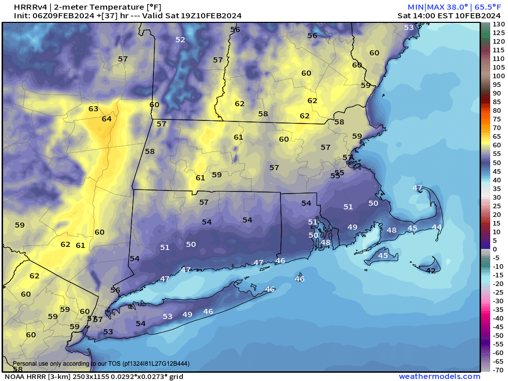
Very mild high temps Saturday
~~~~~~~~~~~~~~~~~~~~~~
TABLE OF CONTENTS
* Daily Celestials (Sun/Moon Data)
* Weekly Weather Nutshell
* Morning Discussion
* TIP: Scroll below for sections, or read all
~~~~~~~~~~~~~~~~~~~~~~
YOUR DAILY CELESTIALS
~~~~~~~~~~~~~~~~~~~~~~
STAR:
–OUR STAR ROSE AT: 6:54am this morning
–OUR STAR SETS AT: 5:14pm this evening
–TOTAL DAYLIGHT TIME: 10 hours and 20 minutes
MOON:
–OUR MOON SETS AT: 4:54pm this afternoon
–MOON SET DIRECTION: West-Southwest
–OUR MOON RISES AT: 7:39am tomorrow morning
–MOON RISE DIRECTION: East-Southeast
–MOON PHASE: New Moon (0.5%)
~~~~~~~~~~~~~~~~~~~~~~
A NOTE FROM OUR SPONSOR
~~~~~~~~~~~~~~~~~~~~~~
Dave Hayes The Weather Nut is Sponsored by Individual Community Members, Patrons, and Tandem Bagel Company… No matter the weather, Tandem Bagel is always there for you at several valley locations to make your mornings brighter! With *New Pizza Bagels(!)*, along with bagels baked fresh daily (including Gluten-Free options), house-whipped cream cheese, coffee, and tons of lunch options, Tandem is the perfect quick stop for lunch, breakfast, or a coffee and bagel to go. Find them in Easthampton, Northampton, Hadley, Florence, and West Springfield, or use their super-streamlined online ordering tool by visiting their website.
~~~~~~~~~~~~~~~~~~~~~~
YOUR WEEKLY WEATHER NUTSHELL
~~~~~~~~~~~~~~~~~~~~~~
–Warm front is passing through this morning
–Dewpoints will rise a bit, and patchy fog is already developing in spots because of this rise
–Patchy fog possible this morning and tomorrow morning
–Morning sprinkles or light icing quits soon, and morning clouds lead to some partly sunny skies later
–Highs reach the mid to upper 40s, and lows hang in the mid 30s
–For Saturday, it’s full on southerly flow, highs reach well into the 50s as any snow lying around melts further, and some folks maybe hit 60º
–As the cold front moves through Saturday later afternoon into the evening, scattered showers arrive
–Some guidance shows a convective look, so I can’t rule out a rumble of thunder or a heavier rain shower
–Lows drop into the 30s, and highs on Sunday reach the upper 30s to mid 40s under partly sunny skies
–On Monday, we’ll see some partly sunny skies early with highs reaching the mid 30s to low 40s
–Clouds will thicken in the afternoon, as our storm ejects off of the DeMarVa Peninsula and tracks east-northeast
–As of now, I think we’ll see snow develop later Monday night, especially south of the VT-NH/MA state line
–This snow would last into Tuesday morning before quitting by afternoon, and could become a 3-6″ or 4-8″ type snowfall for some of us
–However, details are still murky, and it could go out to sea (though I don’t think it will), so stay tuned for updates to what could be an impacted Tuesday morning commute
–For the mid to late week period, our storm likely bombs out into Atlantic Canada, retrogrades west, and drives colder northwesterly air and WIND into our region
–Highs would be near freezing, and winds would gust 25-40mph setting up a cold wind chill
~~~~~~~~~~~~~~~~~~~~~~
YOUR MORNING DISCUSSION
~~~~~~~~~~~~~~~~~~~~~~
Good morning everybody, we’ve got a warm front / cold front combo kicking through the region today (warm front) and tomorrow afternoon/evening (cold front) which will bring some patchy fog each morning, a few sprinkles this morning, and scattered rain showers tomorrow late afternoon into the early evening.
It’ll be mild today with highs 45-50º, but Saturday temps will spike on strong southwest flow well into the 50s, with some possibly hitting 60º.
Scattered showers move in after high temps are reached, and we can’t rule out some heavier showers either side of sunset.
Sunday is milder than average under partly sunny skies, but definitely cooler with highs in the low to mid 40s, and some upper 30s in far northern MA and SVT/SWNH.
Monday features similar temps, with morning partial sunshine giving way to clouds, and snow at night, most likely south of the MA/VT state line.
There are many details to work out still, but this could be a plowable snowfall, a moderate sized storm that is progressive and slides on through the region without slowing or stalling.
Any snow would end by Tuesday afternoon, and then colder air works into the region mid to late next week with windy conditions looking more likely, so lots of changes on the way!
Have a great day!
>>> BE KIND <<<
“Hello babies. Welcome to Earth. It’s hot in the summer and cold in the winter. It’s round and wet and crowded. On the outside, babies, you’ve got a hundred years here. There’s only one rule that I know of, babies: Goddamn it, you’ve got to be kind.”
–Kurt Vonnegut
