
TABLE OF CONTENTS:
–Weekly Nutshell (Quick impact list)
–Sponsor Note (Tandem Bagel Co.)
–NWS Alerts (Advisories, Warnings, Watches)
–Celestial Data (Sun/Moon info)
–Regional Summaries (quick in and out details)
–Morning Discussion (Longer-form explanation)
~~~~~~~~~~~~~~~~~~~~~~
DAVE’S WEEKLY WEATHER NUTSHELL
–Clouds increase this morning, please post sunrise pics
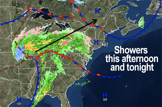
–Rain showers arrive by late morning into early afternoon across the NY-CT/MA/VT border
–Starts as a mix of snow, sleet in the highest northwest MA terrain up into the southern Greens of VT
–Some ice accretion with freezing rain in SVT mountains later, otherwise scattered rain showers, more north, less south
–Southerly winds gust to 25mph, front moves through overnight
–Southwest to west winds gust 25-40mph tomorrow, Wind Advisories possible
–Very mild Friday, well into the 50s for some
–Colder this weekend, more seasonable, blustery Saturday, calmer Sunday
–Clouds build late Sunday with some showers of rain or sleet possible overnight Sunday into early Monday morning south of the Pike
–Milder next week with rain by late week, with winter cold likely moving in by next weekend, but before we jump into the weather discussion/details below, let’s check a note from our local and delicious sponsor, #TandemBagelCo, with their newest location in West Springfield, MA.
~~~~~~~~~~~~~~~~~~~~~~
A NOTE FROM OUR SPONSOR:
Dave Hayes The Weather Nut is Sponsored by Members, Patrons & Tandem Bagel Company… No matter the weather, Tandem Bagel is always there for you at several valley locations to make your mornings brighter! With bagels baked fresh daily (including Gluten-Free options), house-whipped cream cheese, coffee, and tons of lunch options, Tandem is the perfect quick stop for lunch, breakfast, or a coffee and bagel to go. Find them in Easthampton, Northampton, Hadley, Florence, and West Springfield, or use their super-streamlined online ordering tool by visiting their website.
~~~~~~~~~~~~~~~~~~~~~~~~~~~~~~~~
***DHTWN DAILY WEATHER REPORT***
~~~~~~~~~~~~~~~~~~~~~~~~~~~~~~~~
NATIONAL WEATHER SERVICE ALERTS
–None.
DHTWN REMINDER
–The odds of being a human are 1 in 400,000 billion, so do or share something you love today, even in a small way (see Kurt Vonnegut quote at end of post)
DAILY CELESTIAL (STAR):
–OUR STAR ROSE AT: 6:54am this morning
–OUR STAR WILL SET AT: 5:15pm this evening
–TOTAL DAYLIGHT TIME: 10 hours and 21 minutes
NIGHTLY CELESTIAL (MOON):
–OUR MOON WILL RISE AT: 9:12pm this evening
–OUR MOON WILL SET AT: 9:11am tomorrow morning
–MOON RISE DIRECTION: East
–MOON SET DIRECTION: West
–MOON PHASE: Waxing Gibbous (87.7%)
~~~~~~~~~~~~~~~~~~~~~~~~~~~~~~~~
DAILY TERRESTRIAL (ZoneCast)
ZONE 1 (Northern Region)
Southern VT, Southwest NH, N. Taconics NY
–High Temps: Mid 30s to Low 40s
–Low Temps: Mid 30s to Low 40s, temps rise overnight
–Wind: South to southeast gusts to 25 into tonight
–Skies: Clouds increase today, becoming overcast
–Precipitation: Rain showers low elevations, snow/sleet to freezing rain mix high terrain above 2000 feet, some ice accretion, changing to rain by this evening
ZONE 2 (Central Region)
WMass, N. CMass, N. Litchfield County, C./S. Taconics NY
–High Temps: Low to Mid 40s
–Low Temps: Upper 30s to Low 40s, temps rise overnight
–Wind: South to southeast gusts to 25 into tonight
–Skies: Clouds increase today, becoming overcast
–Precipitation: Some sleet/snow mix possible far northwest MA above 2000 feet this late morning, otherwise mostly rain showers by afternoon into evening
ZONE 3 (Southern Region)
S. CMass, S. Litchfield County, NC.CT, & NE.CT
–High Temps: Mid 40s
–Low Temps: Low 40s
–Wind: South to southeast gusts to 25 into tonight
–Skies: Partly sunny early, then increasing clouds
–Precipitation: Rain showers by late morning to early afternoon, ending later this evening
~~~~~~~~~~~~~~~~~~~~~~~~~~~~~~~~
MORNING DISCUSSION
Good morning everybody, if you have any sunrise pics please post them below!! Areas mainly along the CT River and east were treated to a good one, but where ever you are, please color the comments below!
As for our weather, it’s gonna do stuff, have a great day!! I’m kidding!!
Clouds are on the increase this morning from west to east as yet another storm in this Pacific-flow-dominated Winter continues to track northwest of us, up through the Great Lakes into southeast Ontario and southwest Quebec, Canada.
This means while Winter Weather Advisories are hoisted for the high mountains of southern VT for icing potential there, most of us (even low elevations in easternmost and westernmost portions of SVT) should see mostly/all rain showers starting late this morning into tonight. Final rain showers should end either side of midnight.
Highs today will rise into the mid 30s to mid 40s from north to south, and southerly and southeasterly winds will gust 15-25mph at times. Lows won’t be that much different from highs, and temps will rising in the morning behind an occluded frontal passage that will introduce windy and mild conditions for Friday.
In fact, we might see some small-area Wind Advisories posted by NWS later today, as gusts out of the southwest could get up to 30-45mph tomorrow, helping temps rise into the upper 40s to mid 50s!
Cold air will work back into the region at night with a breezy west winds with lows in the mid to upper 20s.
Saturday looks seasonably cold with highs in the low to mid 30s with westerly and northwesterly gusts to 30mph at times, so it will be blustery and chilly under mostly sunny skies as high pressure moves in. Lows will drop into the mid to upper teens for a chilly night as well.
Sunday should start off with some sunshine with highs in the upper 30s to low 40s. However, clouds will build from the south during the afternoon and night, as a big coastal storm is set to storm over the Mid-Atlantic, but should just graze areas south of the Pike with a few showers of rain or sleet with lows near freezing.
Any Monday morning activity clears out quickly with a partly sunny day developing in the low to mid 40s, with lows down into the upper 20s.
It looks fair and mild next week, folks, with highs averaging in the 40s to low 50s with the potential for a late-week rainstorm, though that may shift a bit between now and then.
It certainly is looking like we’ll get a colder air mass in here by that following weekend, with late February into early March looking colder in general. If we’re going to get any snowstorms, that will be our best chance as far as I can see at this moment.
Have a great day!
Let’s Stay Together (click for options).
Join my Free Weekly Nutletter (click to join).
Follow me on Twitter (click to follow).
AND REMEMBER…
“Hello babies. Welcome to Earth. It’s hot in the summer and cold in the winter. It’s round and wet and crowded. On the outside, babies, you’ve got a hundred years here. There’s only one rule that I know of, babies: Goddamn it, you’ve got to be kind.”
–Kurt Vonnegut