
POST TABLE OF CONTENTS:
–Weekly Nutshell (Quick impact list)
–Sponsor Note (Tandem Bagel Co.)
–NWS Alerts (Advisories, Warnings, Watches)
–Celestial Data (Sun/Moon info)
–Regional Summaries (quick in and out details)
–Morning Discussion (Longer-form explanation)
~~~~~~~~~~~~~~~~~~~~~~
DAVE’S WEEKLY WEATHER NUTSHELL
–Sun early today, followed by increasing clouds, seasonably cold
–Snow, ice and rain arrive around dinner time, and continue until the early pre-dawn hours ending as freezing drizzle or plain drizzle
–A coating to an inch of snow and sleet is possible along with a light glaze of freezing rain / ice, especially north of the Pike
–Watch for slippery travel tonight and before dawn tomorrow morning
–Wednesday becomes mostly sunny after morning clouds, breezy
–Clouds increase late at night with more rain (and possibly early-onset snow) for late Thursday morning into early afternoon
–Showery Thursday night, then milder with breaks of sun for Friday
–A weak disturbance may bring mixed showers Friday night into early Saturday, followed by gusty winds out of the northwest
–Seasonably cold and sunny Sunday with continued mild conditions in early next week, but before we jump into the weather discussion/details below, let’s check a note from our local and delicious sponsor, #TandemBagelCo, with their newest location in West Springfield, MA.
~~~~~~~~~~~~~~~~~~~~~~
A NOTE FROM OUR SPONSOR:
Dave Hayes The Weather Nut is Sponsored by Members, Patrons & Tandem Bagel Company… No matter the weather, Tandem Bagel is always there for you at several valley locations to make your mornings brighter! With bagels baked fresh daily (including Gluten-Free options), house-whipped cream cheese, coffee, and tons of lunch options, Tandem is the perfect quick stop for lunch, breakfast, or a coffee and bagel to go. Find them in Easthampton, Northampton, Hadley, Florence, and West Springfield, or use their super-streamlined online ordering tool by visiting their website.
~~~~~~~~~~~~~~~~~~~~~~~~~~~~~~~~
***DHTWN DAILY WEATHER REPORT***
~~~~~~~~~~~~~~~~~~~~~~~~~~~~~~~~
NATIONAL WEATHER SERVICE ALERTS
–Winter Weather Advisories for WMass, CMass, SVT and SWNH 7pm tonight until 1am tomorrow morning.
DHTWN REMINDER
–The odds of being a human are 1 in 400,000 billion, so do or share something you love today, even in a small way (see Kurt Vonnegut quote at end of post)
DAILY CELESTIAL (STAR):
–OUR STAR ROSE AT: 6:56am this morning
–OUR STAR WILL SET AT: 5:12pm this evening
–TOTAL DAYLIGHT TIME: 10 hours and 16 minutes
NIGHTLY CELESTIAL (MOON):
–OUR MOON WILL RISE AT: 7:07pm this evening
–OUR MOON WILL SET AT: 8:32am tomorrow morning
–MOON RISE DIRECTION: East-Northeast
–MOON SET DIRECTION: West
–MOON PHASE: Waxing Gibbous (97.2%)
~~~~~~~~~~~~~~~~~~~~~~~~~~~~~~~~
DAILY TERRESTRIAL (ZoneCast)
ZONE 1 (Northern Region)
Southern VT, Southwest NH, N. Taconics NY
–High Temps: Low to Upper 30s
–Low Temps: Mid 20s to Low 30s
–Wind: Lighter south to southeasterly
–Skies: Sun early, then increasing clouds
–Precipitation: Dry through the day, then snow, sleet and freezing rain showers dinner time to just after midnight with a coating to 1″ snow/sleet and ice glaze possible
ZONE 2 (Central Region)
WMass, N. CMass, N. Litchfield County, C./S. Taconics NY
–High Temps: Mid to Upper 30s
–Low Temps: Upper 20s to Low 30s
–Wind: Lighter south to southeasterly
–Skies: Sun early, then increasing clouds
–Precipitation: Dry through the day, then snow, sleet and freezing rain showers dinner time to just after midnight with a coating to 1″ snow/sleet north and west, with some snow but more sleet and ice glaze south and east is expected
ZONE 3 (Southern Region)
S. CMass, S. Litchfield County, NC.CT, & NE.CT
–High Temps: Mid 30s to Low 40s
–Low Temps: Upper 20s to Low 30s
–Wind: Lighter south to southeasterly
–Skies: Sun early, then increasing clouds
–Precipitation: Dry through the day, then mix of ice and rain tonight, some slippery road ways possible
~~~~~~~~~~~~~~~~~~~~~~~~~~~~~~~~
WHERE’S DAVE?
1. I’ve been reporting our weather daily here for a decade
2. Get my free weekly newsletter here.
3. Visit this page on my website for more connection info.
~~~~~~~~~~~~~~~~~~~~~~~~~~~~~~~~
MORNING DISCUSSION
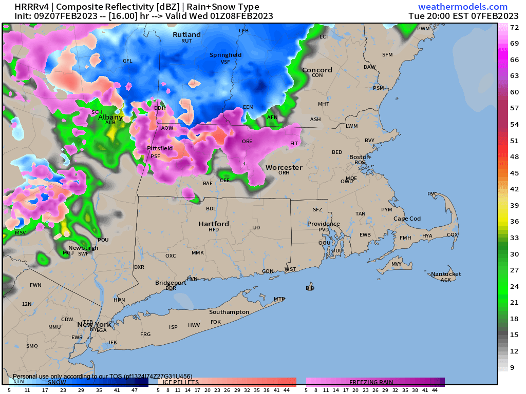
Good morning everybody, our Pacific flow pattern continues which means mostly milder than average temperatures and little winter weather, but we will be dealing with some light wintry mix tonight, which is why the Winter Weather Advisories have been hoisted by the NWS for 7pm to 1am.
For today, early sunshine will give way to a disturbance in The Force ( #StarWarsNut ) which will be tracking east into our region, with low pressure passing far north of us overnight.
This will increase our clouds as the day wears on with highs mostly in the mid 30s to low 40s.
By dinner time (around 6pm or so) we should see showers / periods of snow, sleet and freezing train moving into the region.
Because it will be drier ahead of this system along with antecedent cold air drain from our departing ocean monster storm, we’ll see some evaporative cooling make it cold enough at the surface for wintry precip as milder air works in overhead, ensuring that snow will mix with sleet and freezing rain.
So, expect a mixed bag tonight with potential for freezing rain to produce ice glazes on surfaces, making for slippery travel. A coating to an inch of snow and sleet is also possible.
Lows will drop into the upper 20s to low 30s, and even though the mixed precip quits by midnight or so, it may continue as freezing drizzle before it all ships out of here before Wednesday’s dawn.
A sunny and breezy day will follow for our Wednesday with highs in the upper 30s to low 40s with northwest winds gusting 10-20mph at times, and lows in the mid to upper 20s as clouds build back during the pre-dawn hours.
Thursday will quickly cloud up and by late morning, another frontal boundary draped off of a storm passing well north of us will overspread the region with mostly rain showers, but a few snow showers in northwest MA or SVT are possible late morning into early afternoon.
Highs will reach the upper 30s to mid 40s and showers will continue into the first part of the night with lows in the 30s.
Southwest flow sets up in earnest Friday with much milder temps, highs reaching the upper 40s to mid 50s, which is substantially above average.
It looks mostly cloudy with more showers of rain or snow possible for Friday night into early Saturday with colder air incoming for the weekend in northwesterly winds gusting to 30mph at times with highs in the 30s both days with increasing sunshine into Sunday.
Early next week looks milder with fair weather to kick the week off, and there are no big storms in sight at the moment, folks.
Have a great day!
Let’s Stay Together (click for options).
Join my Free Weekly Nutletter.
Follow me on Twitter (click to follow).
AND REMEMBER…
“Hello babies. Welcome to Earth. It’s hot in the summer and cold in the winter. It’s round and wet and crowded. On the outside, babies, you’ve got a hundred years here. There’s only one rule that I know of, babies: Goddamn it, you’ve got to be kind.”
–Kurt Vonnegut