
SECURELY BECOME A 2025 WEATHER NUT SUPPORTER TODAY
–> When 4% of readers support at any level,
this community weather resource can continue
(Secure options include Cards, PayPal, Venmo, Check)
~~~~~~~~~~~~~~~~~~
TABLE OF CONTENTS
* Daily Celestials (Sun/Moon Data)
* Sponsor Note
* Morning Discussion
* TIP: Scroll below for sections, or read all
~~~~~~~~~~~~~~~~~~~~~~
YOUR DAILY CELESTIALS
~~~~~~~~~~~~~~~~~~~~~~
STAR:
–OUR STAR ROSE AT: 6:57am this morning
–OUR STAR SETS AT: 5:11pm this evening
–TOTAL DAYLIGHT TIME: 10 hours and 14 minutes
MOON:
–OUR MOON RISES AT: 11:09am this morning
–MOON RISE DIRECTION: East-Northeast
–OUR MOON SETS AT: 3:22am tomorrow morning
–MOON SET DIRECTION: Northwest
–MOON PHASE: Waxing Gibbous (62.9%)
~~~~~~~~~~~~~~~~~~~~~~
A NOTE FROM OUR SPONSOR
~~~~~~~~~~~~~~~~~~~~~~
Dave Hayes The Weather Nut is Sponsored by Individual Community Members, Patrons, and Tandem Bagel Company… No matter the weather, Tandem Bagel is always there for you at several valley locations to make your mornings brighter! With *New Pizza Bagels(!)*, along with bagels baked fresh daily (including Gluten-Free options), house-whipped cream cheese, coffee, and tons of lunch options, Tandem is the perfect quick stop for lunch, breakfast, or a coffee and bagel to go.
You can either 1) visit them in Easthampton, Northampton, Hadley, Florence, and/or West Springfield, 2) hire them to cater your next event, or 3) use their super-streamlined online ordering tool by visiting their website and clicking the “Catering” or “Order Online” links.
~~~~~~~~~~~~~~~~~~~~~~
YOUR MORNING DISCUSSION
~~~~~~~~~~~~~~~~~~~~~~
Good morning folks, snow is moving quickly into the greater WMass region this morning, and has some convective elements, so I expect it to move in and become steady pretty quickly between 7-9am primarily (though snow is already reported in parts of northern CT and probably the southern Berkshires as I type this).
Our stout, potent, and quick-moving wave will sweep the region west to east bringing accumulating snow this Thursday morning, which should last into early afternoon in varying intensity before mixing with or changing to sleet and/or freezing rain, though the bulk of the steadier precip may fall as snow as milder air aloft pushes toward the MassPike by the middle of the day.
Generally, everyone in the greater WMass region will see a 2-4” accumulation, with a few sub-2” amounts in parts of northern CT. Conversely, there will be an area of 3-5” or so up along the Route 2 corridor and points north into SVT and SWNH with some sleet and/or ice glaze on top.
Highs will not climb past freezing for most of us today, hanging in the upper 20s to low 30s. Precip in whatever form it’s falling winds down between 4-6pm, possibly winding down as some freezing drizzle.
Lows will drop into the mid to upper 20s as a cold front swings through the region by Friday morning, which will bring another active day of weather… go figure!
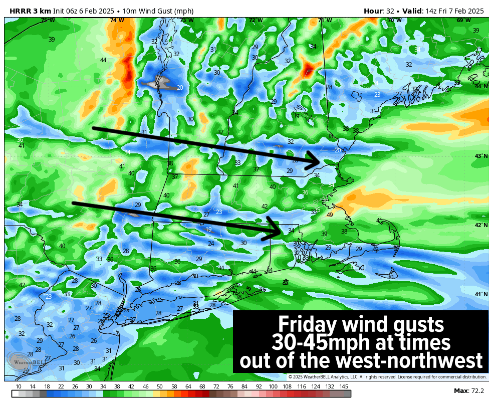
Behind the frontal passage, we’ll see northwest winds pick up and gust 30-45mph on Friday, with potential for Wind Advisory hoistings by the NWS in the Berkshires or western hilltowns. Some isolated outages will be possible.
——————-
SECURELY BECOME A 2025 WEATHER NUT SUPPORTER TODAY
–> When 4% of readers support at any level,
this community weather resource can continue
(Secure options include Cards, PayPal, Venmo, Check)
——————-
Skies will be mixed on Friday, with highs in the upper 20s to mid 30s along with scattered lake effect and/or upslope snow showers in the Berkshires, Taconics, and SVT. I can’t rule out addition al light accumulations of a coating to 2” in some spots by Friday night, and we may even see a multi-3-lake long-form snow band setup, connecting Great Lakes Superior, Huron and Ontario, which is always geeky fun for me to see.
Lows will drop into the teens under partly cloudy skies with Saturday looking like a less windy, and fairly seasonable early February day with highs in the upper 20s to low 30s (actually that’s below average temp-wise).
Clouds will increase as a stronger low pressure system slides east out of the Ohio Valley and likely tracks just south of Long Island, pushing accumulating snowfall back into the greater WMass region, starting sometime between 9pm-Midnight Saturday evening.
Snow will fall moderate to heavy overnight and through Sunday morning, tapering to snow showers by afternoon. I do not expect any sleet to mix in, except for perhaps parts of northern CT.
This looks, for now, like all snowfall for much of the greater WMass region and at this early range, it still appears to be a 4-8” type snow, but some areas may even hit 10”, so the plows likely come out throughout Sunday morning.
Lows Saturday night drop into the upper teens to low 20s with highs Sunday in the 25-30º range, with Sunday night lows in the upper single digits to teens as colder air is drawn, setting up a very, very wintry look as we start the next work week.
Monday sees brief high pressure move into the region, but by Tuesday, yet another snowstorm is possible as this pattern is loaded with winter storms, now with no real end in sight.
Please post any reports for this morning’s incoming storm below to let me/us know what’s happening in your woodsy neck.
I will keep you updated today and throughout this stretch, and if my work holds some value for you and you’d like to support it, please click the secure link below for available options and thank you.
SECURELY BECOME A 2025 WEATHER NUT SUPPORTER TODAY
–> When 4% of readers support at any level,
this community weather resource can continue
(Secure options include Cards, PayPal, Venmo, Check)
“Follow your bliss and the universe will open doors for you where there were only walls.”
― Joseph Campbell