
WEEKLY WEATHER NUTSHELL
–Brutally cold early this morning with lows down to -30, and wind chills still down to -40
–Winds only gusting 15-25mph this morning
–Winds pick up and gust up to 30mph with wind chills still down to 10 below zero with highs in the teens today
–Mostly sunny today, with lows in the single digits to low teens tonight, rising by dawn
–Partly sunny Sunday and Monday with highs in the upper 30s to mid 40s, and gusty out of the southwest by Sunday afternoon
–A few showers by Tuesday evening with a front, then more showers possible Friday otherwise mild and fair weather with partly sunny skies on average
–Possible winter storm by next Sunday
——————————————-
***DHTWN DAILY WEATHER REPORT***
——————————————-
Good morning everybody, we still have temps below zero just about everywhere in the -5 to -25º range which is about as cold as it gets in southern New England historically.
Boston just hit its first double digit below zero low temp for the time since 1957!
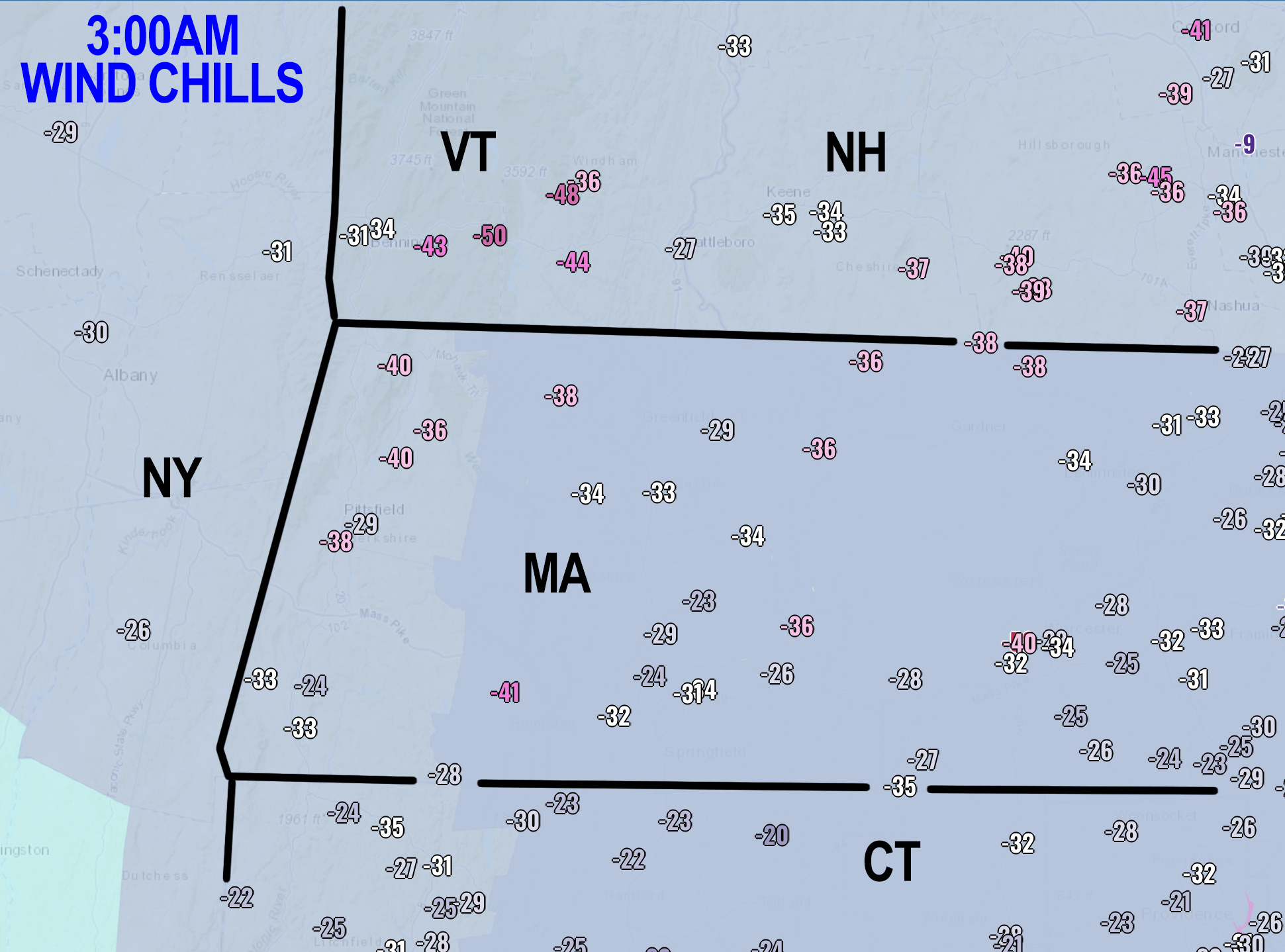
Wind chills went down to -20 to -50º last night, which I personally have never seen in this region before. It takes a historically anomalous air mass to produce widespread Wind Chill Warnings of the kind that are expiring by this afternoon across our region.
We’ll have mostly sunny skies today, and strong high pressure will push through our region and off the coast to our south, putting us into southwest flow by tomorrow. Meanwhile, low pressure will sweep into the Great Lakes region.
Just like the Labrador Low and Northern Plains High combined to siphon the Arctic southeast into our region through this morning, the Mid-Atlantic High and Great Lakes Low will combine to siphon much milder air from the Mid-Atlantic and Southeast U.S. into New England starting tomorrow into next week.
So, highs today in the teens with westerly wind gusts up to 30mph still puts intermittent wind chill down below zero, with slackening wind overnight and lows in the teens to low 10s, and rising by dawn.
Sunday is way milder, and in some cases, we’ll see 60 to 70-degree temperature rises from this morning, in under 36 hours!!
Highs will reach the upper 30s to mid 40s with a blend of sun and clouds, and lows will dip into the mid to upper 20s.
Similar set up on Monday and Monday night, with a frontal boundary that will bring some rain showers by Tuesday afternoon which will be cloudier but again in the upper 30s to mid 40s.
Wednesday looks like the pick of the week at this point with mostly sunny skies and brief high pressure moving through, followed by more showers possible late week with a more substantial system.
Beyond that, cold air may move back in by next weekend, and depending a storm track out of the southeast U.S., we could be dealing with a winter storm by next Sunday, so stay tuned for updates.
Have a great day and let me know what your low temps were this morning! Stay warm, and if you lost power, hang in there, things are moving in the right direction!
Let’s Stay Together (click for options).
Join my Free Weekly Nutletter (click to join).
Follow me on Twitter (click to follow).
AND REMEMBER…
“Hello babies. Welcome to Earth. It’s hot in the summer and cold in the winter. It’s round and wet and crowded. On the outside, babies, you’ve got a hundred years here. There’s only one rule that I know of, babies: Goddamn it, you’ve got to be kind.”
–Kurt Vonnegut