
–> With your small contribution, this public outlet persists
–> We’re 57% towards reaching my 4% reader support goal
–> Drive ends 3/16, I’d be grateful for your support today
–> SecureClick
~~~~~~~~~~~~~~~
TABLE OF CONTENTS
* Daily Celestials (Sun/Moon Data)
* Sponsor Note
* Morning Discussion
* TIP: Scroll below for sections, or read all
~~~~~~~~~~~~~~~
YOUR DAILY CELESTIALS
~~~~~~~~~~~~~~~~~~~~~~
STAR:
–OUR STAR ROSE AT: 6:26am this morning
–OUR STAR SETS AT: 5:39pm this evening
–TOTAL DAYLIGHT TIME: 11 hours and 13 minutes
MOON:
–OUR MOON ROSE AT: 6:51am this morning
–MOON RISE DIRECTION: East
–OUR MOON SETS AT: 6:40pm this evening
–MOON SET DIRECTION: West
–MOON PHASE: Waxing Crescent (0.3%)
~~~~~~~~~~~~~~~~~~~~~~
A NOTE FROM OUR SPONSOR
~~~~~~~~~~~~~~~~~~~~~~
Dave Hayes The Weather Nut is Sponsored by Individual Community Members, Patrons, and Tandem Bagel Company… No matter the weather, Tandem Bagel is always there for you at several valley locations to make your mornings brighter! With *New Pizza Bagels(!)*, along with bagels baked fresh daily (including Gluten-Free options), house-whipped cream cheese, coffee, and tons of lunch options, Tandem is the perfect quick stop for lunch, breakfast, or a coffee and bagel to go.
You can either 1) visit them in Easthampton, Northampton, Hadley, Florence, and/or West Springfield, 2) hire them to cater your next event, or 3) use their super-streamlined online ordering tool by visiting their website and clicking the “Catering” or “Order Online” links.
~~~~~~~~~~~~~~~~~~~~~~
YOUR MORNING DISCUSSION
~~~~~~~~~~~~~~~~~~~~~~
Good morning folks, we’ve got of changes coming in the Weather Department over the next week with a variety of conditions expected, and ups-and-downs in temperature, wind, and precipitation types so let’s jump in.
For today, we have fair weather developing with a mild start mostly in the 30s with some upper 20s in the high terrain.
Fog dissipated overnight after some drier air worked into the region and dew point temps pulled back off of the air temps to desaturate the air enough for fog evaporation.
For today (behind yesterday’s system) west-northwest winds will gust 20-30mph at times, and quiet down by later this afternoon and evening as our next Clipper system approaches. Highs under mostly sunny skies will climb into the mid 30s to low 40s, with clouds increasing later this afternoon.
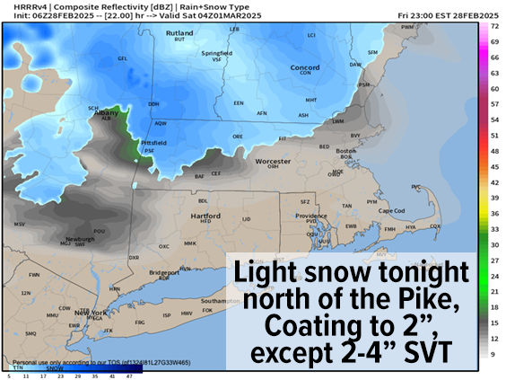
Between 6-8pm or so, light snow should press east into northwest MA and southern VT and then mostly stay north of the Pike, spreading east through the rest of SVT, SWNH, WMass and northern CMass into the pre-dawn hours.
This will result in a coating to 2” of snow for most of us by dawn tomorrow. Some areas in SVT/SWNH may see 2-4” being closer to the low center passing through northern New England.
Southerly wind gusts will pick up into Saturday morning and then turn southwest as the storm pulls away Saturday morning, gusting up to 30mph at times tomorrow ahead of an incoming sharp and potent cold front which moves through by early afternoon.
Highs will soar well into the 40s tomorrow early under partly sunny skies before the front moves through with a chance for scattered snow squalls mixed with rain in the early to mid afternoon, which could re-coat some areas and cause lowered visibility briefly.
Temps will then crash as west-northwest wind gusts kick up behind the front and gust 25-40mph at times, with lows expected in the upper single digits to teens with wind chills at or below zero!
———
VOTES FOR DAVE’S WORK
“He’s great with details, he’s funny, he’s a great teacher & he’s an amazing writer!!”
–Dusty M.
“I am a builder from Chicopee. We depend on accurate forecasts to feed our families, the weather dictates when we start a project what work we’ll do and our scheduling. You are my go-to guy for weather. I will happily support your work in the same manner in which you help to support mine, thank you.”
–Rich R.
———
Sunday and Monday look to be quite sunny with high pressure moving towards us out of Canada, with Sunday and Sunday night representing the peak cold in this quick Arctic blast.
Sunday looks breezy with highs only reaching the upper teens to mid 20s with lows in the single digits above and below zero!
Monday moderates a bit, but will still be cold with highs in the mid 20s to low 30s with lows in the teens. Both Sunday and Monday should feature clear nights.
On Tuesday, high pressure positions south of us and pumps milder air into the region with highs in the low to mid 40s with clouds increasing at night and lows near freezing.
As of now, it appears that a potent low pressure system will be cranking up and it tracks northeast into the eastern Great Lakes staying to our northwest keeping us on the warm side of the storm.
This should push rain, heavy at times, into the greater WMass region by Wednesday morning into Wednesday night and Thursday with very mild temps into the 40s and 50s, prior to colder air moving into our region on the back side of this system on Thursday night into Friday. At that time, snow showers and wind may develop as the upper trough comes through.
And if that wasn’t enough, I am still monitoring for a potential last-chance-at-winter storm for the March 9th or 10th period, so there will be lots of weather to monitor and talk about over the next 10 days as we move into manic March!
Have a great day!
–I want to continue earning your trust in every storm
–I’m your neighbor & I care about your safety
–Without 4% of you, I’d already be a WMass footnote
–If you look to me, let’s stay connected
–Any amount helps, drive ends March 16th
“Follow your bliss and the universe will open doors for you where there were only walls.”
― Joseph Campbell