
SECURELY BECOME A 2023 MEMBER OR SUPPORTER AT ANY LEVEL TODAY(Options include Cards, PayPal, Venmo, or Check)
~~~~~~~~~~~~~~~~~~~~~~
TABLE OF CONTENTS:
–Weekly Nutshell (Quick impact list)
–Sponsor Note (Tandem Bagel Co.)
–NWS Alerts (Advisories, Warnings, Watches)
–Celestial Data (Sun/Moon info)
–Regional Summaries (quick in and out details)
–Morning Discussion (Longer-form explanation)
~~~~~~~~~~~~~~~~~~~~~~
DAVE’S WEEKLY WEATHER NUTSHELL
–Partly sunny start to Monday, clouds increase
–Highs in the low to mid 30s, light wind becomes calm
–Snow arrives between 8pm-Midnight from the NY state line to Worcester/Fitchburg
–Snow will fall moderately to heavily at time, reaching up to an inch per hour, especially in the western hillitowns and eastern Berkshires
–Tuesday morning commute to be impacted, slow going
–By Tuesday mid-morning, snow tapers down to periods of light to occasionally moderate snow, might stop at times
–Any snow ends after dinner time with a general 4-7″ across the region, but more like 6-10″ in the western hilltowns, eastern Berkshires, northern Litchfields an southern Greens
–Possible 2-5″ zone for southwest NH into Brattleboro/Putney by the river, and also over in the Bennington area of SW.VT
–Wednesday and Thursday are milder in the 40s, with partly start Wed then mostly rain showers Wednesday night into Thursday
–Major coastal winter storm possible for Friday into Friday night, departing Saturday followed by a seasonably cold, pleasant weekend, but before we jump into the weather discussion/details below, let’s check a note from our local and delicious sponsor, #TandemBagelCo, with their newest location in West Springfield, MA.
~~~~~~~~~~~~~~~~~~~~~~
A NOTE FROM OUR SPONSOR:
Dave Hayes The Weather Nut is Sponsored by Individual Community Members, Patrons & Tandem Bagel Company… No matter the weather, Tandem Bagel is always there for you at several valley locations to make your mornings brighter! With bagels baked fresh daily (including Gluten-Free options), house-whipped cream cheese, coffee, and tons of lunch options, Tandem is the perfect quick stop for lunch, breakfast, or a coffee and bagel to go. Find them in Easthampton, Northampton, Hadley, Florence, and West Springfield, or use their super-streamlined online ordering tool by visiting their website.
~~~~~~~~~~~~~~~~~~~~~~~~~~~~~~~~
***DHTWN DAILY WEATHER REPORT***
~~~~~~~~~~~~~~~~~~~~~~~~~~~~~~~~
NATIONAL WEATHER SERVICE ALERTS
–Winter Storm Warnings are up for all of WMass, CMass, northern CT, and most of southern VT
–Winter Weather Advisories are up for southwest NH, and eastern parts of southern VT
DHTWN REMINDER
–It doesn’t take much to do a nice thing for somebody that you don’t know.
DAILY CELESTIAL (STAR):
–OUR STAR ROSE AT: 6:28am this morning
–OUR STAR WILL SET AT: 5:37pm this evening
–TOTAL DAYLIGHT TIME: 11 hours and 9 minute
NIGHTLY CELESTIAL (MOON):
–OUR MOON WILL SET AT: 1:19am tomorrow morning
–OUR MOON WILL RISE AT: 10:22am tomorrow morning
–MOON SET DIRECTION: Northwest
–MOON RISE DIRECTION: Northeast
–MOON PHASE: Waxing Gibbous (51.37)
~~~~~~~~~~~~~~~~~~~~~~~~~~~~~~~~
DAILY TERRESTRIAL
ZONE 1 – Northern Region
(Southern VT, Southwest NH)
–High Temps: Upper 20s to Low 30s
–Low Temps: Upper Teens to Low 20s
–Winds: Light to calm, breezy out of the east/southeast tonight
–Sky Cover: Partly sunny, then overcast
–Precipitation: Dry today, snow moves in 8-11pm, steadiest/heaviest snow through dawn
ZONE 2 – Central Region
(Western MA, North-Central MA, Northern Litchfield CT)
–High Temps: Low to Mid 30s
–Low Temps: Low to Mid 20s
–Winds: Light to calm, breezy out of the east/southeast tonight
–Sky Cover: Partly sunny, then overcast
–Precipitation: Dry today, snow moves in 8-11pm, steadiest/heaviest snow through dawn
ZONE 3 – Southern Region
(South-Central MA, Northern CT)
–High Temps: Low to Mid 30s
–Low Temps: Mid to Upper 20s
–Winds: Light to calm, breezy out of the east/southeast tonight
–Sky Cover: Partly sunny, then overcast
–Precipitation: Dry today, snow moves in 8-12am, steadiest/heaviest snow through dawn
~~~~~~~~~~~~~~~~~~~~~~~~~~~~~~~~
MORNING DISCUSSION
Good morning everybody, we’ve got a plowable, moderate-sized snowstorm on the way for tonight and tomorrow, with the brunt of the heaviest and steadiest snow moving through between Midnight and 7am tomorrow morning.
Given our secondary low forming overnight and encouraging northeast flow, and our high pressure system over Atlantic Canada encouraging the same, this one’s gonna be all snow, folks, and for this writer, I couldn’t be happier – not gonna be wishing this was a slop/mix/junk storm!!!
For this morning, a nice sunrise has transpired, and produced some beautiful Northern Lights even down into WMass last night, did you get any pics or glimpses of it?
LET’S APPRECIATE OUR STAR AND LIFE
Let’s take a minute and thank our star for our lives: without it, we’d never have had a chance to come here and even have one laugh, eat one meal, share one moment of connection with a friend, or experience life at all.
We’re very lucky beings, even despite all the hardships and brutality that is part of humanity’s existence historically and presently.
I know I feel blessed to have this opportunity to serve you, and connect here, so I thank you for that.
BACK TO WEATHER, DAVE
Yes, back to the weather! Today is partly sunny early, with clouds increasing, and skies becoming overcast by the afternoon.
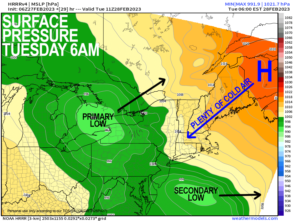
Our primary storm is quite strong now, but will truck northeast through Lake Huron and Ontario, weakening as it does so.
This weakening primary low gives way to a strengthening secondary low off of the northern DelMarVa coast, and will track east, staying well south of New England, coming close to The Benchmark.
A large snow shield will push northeast into the greater WMass region between 8pm and midnight tonight.
Snow will fall heavily at times between midnight and 7am, by which time it will taper to periods of light snow, which may reach periods of moderate intensity at times. One-inch-per-hour rates may fall at times overnight.
The bulk of the accumulation happens tonight into early Tuesday morning with only additional light accumulations Tuesday into the early evening when it tapers off.
Highs will be in the low to mid 30s today with lows in the 20s.
——————-
IF YOU FEEL SIMILARLY #2023MemberDrive
“Dave is constantly reviewing and updating with attention to all of our different little weather zones which can vary drastically. Plus, I love that the community of followers help each other know what road conditions and weather effects are in each location in real time! A truly community-centered service!!” –Taiko C.
–> Your Contributions Help Sustain this Community Resource
–> Click this secure link, many options to choose from
——————-
Snow accumulations will be mostly 4-7″ across much of the Pioneer Valley into northern CT, and CMass.
I do think a jackpot zone of 6-10″ will fall in the eastern Berkshires, western hilltowns, northern Litchfield County highlands, and the southern Greens of VT due to southeast and easterly winds picking up overnight and enhancing those east-slopes with heavier snow.
In fact, it’s more western Hampshire, western Hampden, southeast Berkshires and northeast Litchfield County into the northwest nub of Hartford County where the best chance for a 10″ result is most likely.
Tuesday is intermittently snowy with light to moderate snow, then it tapers off in the early evening with highs in the 30s, and lows in the 20s.
Wednesday starts off partly sunny, and given that our primary low tracks northeast up the St. Lawrence River Valley, southwest flow will bring milder low to mid 40s into our region for highs Wednesday and Thursday.
Clouds increase Wednesday afternoon, with periods of rain showers (possibly mixed with snow in the high terrain) at night and through Thursday as a weak wave track east through northern New England.
By Friday, we’re watching a potentially juicy, single low pressure system that will tap Gulf of Mexico moisture and track northeast up the Appalachians and possibly stay south of New England, bringing a moderate to major snowstorm to our region, with some mix possible south of the Pike.
Obviously lots can change, but it’s strongly signaled and has other forecast guidance support, so please stay tuned for updates on what could become a one-two winter punch!
Have a great day, I will update once or twice later today of course as we get closer to tonight’s system, so watch for updates, and if you appreciate and value my work, please consider supporting it via my 2023 Member/Support Drive… any monthly or one-time amount is helpful, thank you:
2023 MEMBER/SUPPORT DRIVE SECURE LINK.
Let’s Stay Together (click for options).
AND REMEMBER…
“Hello babies. Welcome to Earth. It’s hot in the summer and cold in the winter. It’s round and wet and crowded. On the outside, babies, you’ve got a hundred years here. There’s only one rule that I know of, babies: Goddamn it, you’ve got to be kind.”
–Kurt Vonnegut