
TABLE OF CONTENTS
* Daily Celestials (Sun/Moon Data)
* Sponsor Note
* Morning Discussion
* TIP: Scroll below for sections, or read all
~~~~~~~~~~~~~~~~~~~~~~
YOUR DAILY CELESTIALS
~~~~~~~~~~~~~~~~~~~~~~
STAR:
–OUR STAR ROSE AT: 6:29am this morning
–OUR STAR SETS AT: 5:37pm this evening
–TOTAL DAYLIGHT TIME: 11 hours and 8 minutes
MOON:
–OUR MOON SETS AT: 4:04pm this afternoon
–MOON SET DIRECTION: West-Southwest
–OUR MOON RISES AT: 6:27am tomorrow morning
–MOON RISE DIRECTION: East-Southeast
–MOON PHASE: Waning Crescent (3.3%)
~~~~~~~~~~~~~~~~~~~~~~
A NOTE FROM OUR SPONSOR
~~~~~~~~~~~~~~~~~~~~~~
Dave Hayes The Weather Nut is Sponsored by Individual Community Members, Patrons, and Tandem Bagel Company… No matter the weather, Tandem Bagel is always there for you at several valley locations to make your mornings brighter! With *New Pizza Bagels(!)*, along with bagels baked fresh daily (including Gluten-Free options), house-whipped cream cheese, coffee, and tons of lunch options, Tandem is the perfect quick stop for lunch, breakfast, or a coffee and bagel to go.
You can either 1) visit them in Easthampton, Northampton, Hadley, Florence, and/or West Springfield, 2) hire them to cater your next event, or 3) use their super-streamlined online ordering tool by visiting their website and clicking the “Catering” or “Order Online” links.
~~~~~~~~~~~~~~~~~~~~~~
YOUR MORNING DISCUSSION
~~~~~~~~~~~~~~~~~~~~~~
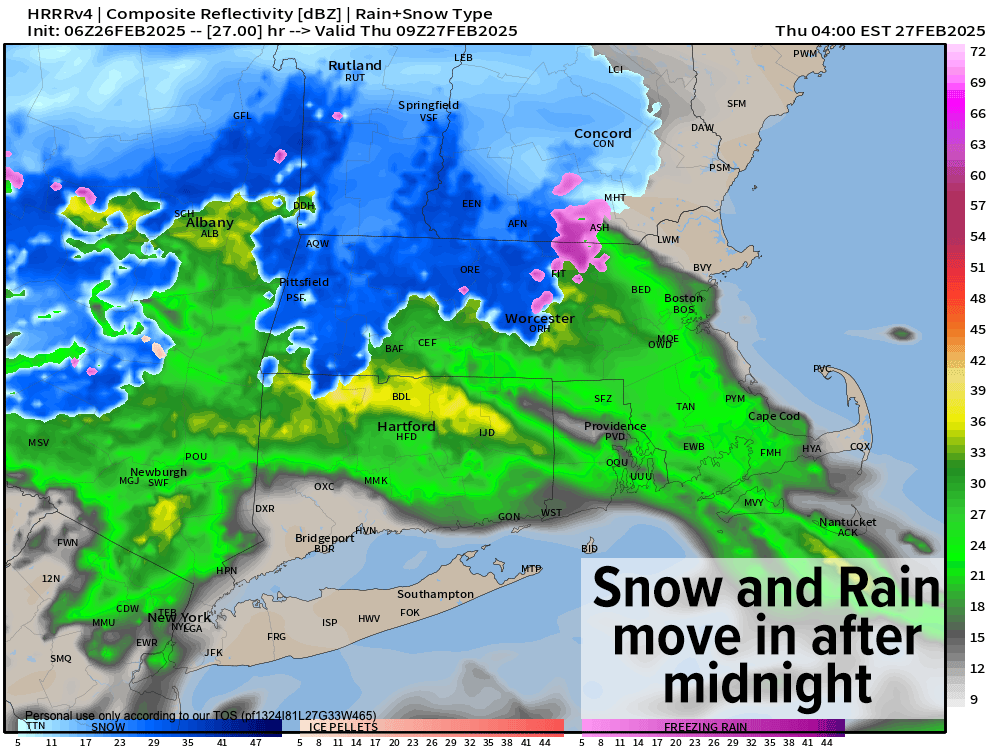
Good morning folks, we have a lovely day ahead with brief high pressure nosing in from the south, ahead of an incoming low pressure system that will track east through northern New England through Thursday bringing snow and rain (and maybe brief icing toward dawn in spots).
For today, west winds will gust 20-30mph behind last night’s frontal passage, and highs will reach into the upper 30s to mid 40s under partly to mostly sunny skies. Clouds will increase tonight with lows in the mid 20s to low 30s, setting the stage for snow or a mix of snow and rain to push in after midnight.
Snow will accumulate in the pre-dawn hours in the central/northern Berkshires, western hilltowns, Franklin County, northern CMass and SVT/SWNH with some snow and rain mix in the CT River Valley south and east.
I am less sure about southern Berkshire County down into Litchfield, though elevation likely is the difference between a coating to an inch of snow overnight and scattered coatings with a rain mix (Great Barrington, for example, is usually milder).
The aforementioned northern and high terrain areas which tend to do the best with snow should see a coating to 2” mostly, with some 2-4” amounts in far northwest MA up into SVT.
Snow transitions to rain everywhere on Thursday morning as milder air works into the region and feeds south to north into our storm passing north of us. Some icing may result in this transition for northern areas, but otherwise we go to showers (some maybe heavier) on Thursday with highs in the 40s.
Lows Thursday night dip into the mid 20s to low 30s with some upslope snow showers in the Berkshires or a few lingering valley rain showers.
We dry out on Friday with sunshine developing, and wind too, with blustery gusts out of the northwest up to 25-40mph at times. Highs will be cooler, reaching the 30s for most of us.
Clouds will increase Friday night ahead of our next Clipper system which passes a bit closer to southern New England, and our lows will be even colder as they drop into the upper teens to mid 20s.
Light snow will move in again around or after midnight with some light accumulations, and again transition to rain in the lower elevations and rain/snow mix in the high terrain Saturday as temps come up into the upper 30s to 40s for highs.
Behind THAT system, we get a late-winter shot of cold Canadian air as we move into the manic month of March.
Lows Saturday night will plummet into the upper single digits to mid teens as winds kick up out of the northwest, driving wind chills down to near 0º at times.
Sunday and Monday produce dry weather with wintry cold temps as highs climb into the teens and 20s on Sunday as blustery winds continue to gust Sunday, Sunday night and into Monday, upwards of 25-35mph.
Sunday night is the peak cold of this short cold snap, with lows bottoming out into the single digits for most of us. Highs on Monday climb into the 20s to low 30s with lows in the teens as fair weather continues.
We’ll be warming up into the middle of next week when a good bout of rain is possible for Wednesday/Thursday. It’s behind that system that we may cool down and have a shot at one more winter storm.
Otherwise, I think we’re going to be springing into Spring, folks, and for many that will be good news.
Have a great day!
“Follow your bliss and the universe will open doors for you where there were only walls.”
― Joseph Campbell