
–> Resources we support, remain–> Resources we don’t, wither–> Your Contributions Today Help Sustain this Community Weather Resource –> Click the secure link below to select from many 2023 support options, thanks!–> CLICK: https://westernmassweather.com/support-network/
——————-
Good morning everybody, we’re kicking off our Sunday with very cold temps in the teens and 20s, and with some patchy fog around and mist, there are likely some icy surfaces.
Temps will come up today as a storm tracks well northeast of us, with highs expected in the 35-40º range, which will collapse/melt part of the delicately-stacked dendrite snow puff (DSDSP for short, which is almost as intuitive as DHTWN as an acronym) on the ground from yesterday.
Now that I think of it, *I’m* a delicately-stacked dendrite snow puff! Nice to meet you!
So, a Clipper low dives southeast through Maine today, and brings some scattered snow showers, while some remain dry. Also, as temps come up, some showers will be in the form of rain. Some scattered coatings are possible, but I am not expecting a widespread coating to 3″ that we saw yesterday.
For tonight, that system departs out to sea, and our lows will drop into the mid to upper teens under partly cloudy skies.
For Monday, we’ll get a sunny start but clouds will be increasing, and highs will climb into the low to mid 30s.
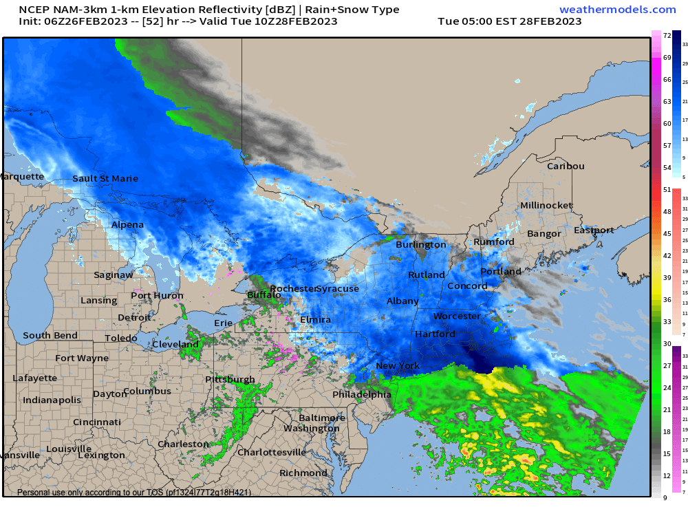
I’ll be watching a storm system track northeast into the eastern Great Lakes region, with a secondary low developing off of the DelMarVa Peninsula, but it will be forced to track due east because of blocking high pressure northeast of Maine.
This setup sort of splits the parent low from the secondary low more than we would normally see in these types of storm setups.
This carries the highest lift and precip rates south of our region, and also thins out the energy and lift from the parent low.
Fortunately for snow lovers, the parent low is trucking across the country with quite a bit of atmospheric juice, so we’ll essentially get an overrunning event which should produce a widespread 3-6″ of snowfall across the region.
I do think there will be a 5-10″ jackpot zone, but I’m still unsure whether that’s the typical far northwest MA into SVT, and am leaning more toward the southeastern Berkshires, southwest hilltowns (western Hampshire/Hampden) and northern Litchfield County which is closer to the coastal low.
I will update again this evening and of course all through the day Monday starting first thing in the morning, but that’s how it looks now to me.
Snow starts Monday night between 8-10pm, and heaviest falls overnight, and then we’ll have periods of light snow on Tuesday before it quits by about dinner time.
Highs Tuesday will reach the mid 30s, and lows will sit down to near 20 as we start to clear out.
High pressure builds into the region on Wednesday with partly sunny skies, and milder highs into the low 40s, with lows near freezing as clouds increase, and rain and snow showers arrive after midnight.
Thursday features a milder, less organized system that brings mostly rain showers to the region with highs well into the 40s.
Then we watch a developing storm system for Friday into Saturday that could bring another plowable snowfall to the region, possibly larger than the one tomorrow night, so stay tuned for updates on that potential.
Have a great day, and if you’d like to support my work, my annual Member Drive is up, and you can join any level or choose a contribution that fits your budget, thank you.