
Light snow this Sat. afternoon
SECURELY BECOME A 2023 MEMBER OR SUPPORTER AT ANY LEVEL TODAY(Options include Cards, PayPal, Venmo, or Check)
~~~~~~~~~~~~~~~~~~~~~~
Good morning everybody, it is wicked chilly willy out there!! Temps in the single digits and teens with light to calm wind, and clouds increasing ahead of our next shortwave that is set to bring some snow showers to the region this afternoon.
I can count 5 potential systems over the next week alone, so we’re definitely in an active pattern, but 3 of the 5 are mostly weak/light impacts, one is more of a moderate impact (Monday night into Tuesday), and then next weekend has the potential for a larger impact, so in other words, as the Mary Tyler Show theme croons, we’re gonna make it after all! #Meow
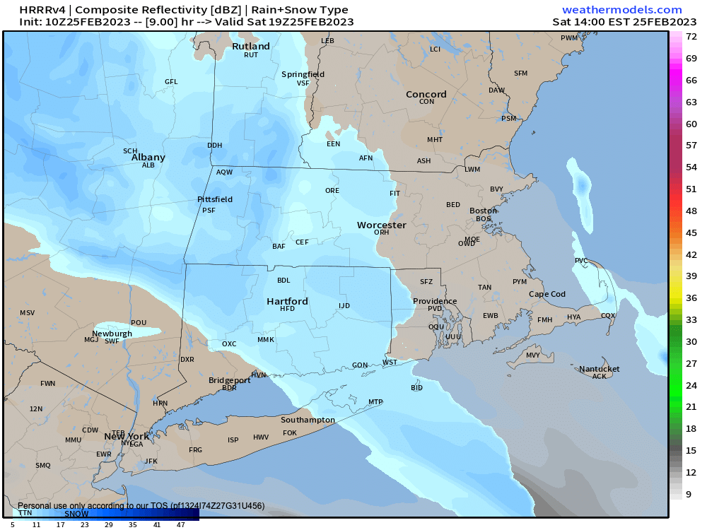
For today, clouds increase, and a wave tracks east out of Lake Erie and will spread a period of light snow and snow showers into the greater WMass region.
Many areas should see coatings of light fluff, but some other (especially the high terrain) will see an inch, or maybe two before this system trucks east and out of here by the early evening.
Highs will only reach the upper teens to low/mid 20s, so it’ll be quite cold, but at least winds will be light. Lows drop into the low to mid teens tonight.
For tomorrow, a more robust but farther-from-us Alberta Clipper will dive southeast through northern NH and Maine, and while anyone could see a snow shower by late morning and into the afternoon (possibly mixed with or as plain rain in the Pioneer Valley from Northampton south), there are two areas that may pick up light accumulations.
The first is southwest NH into northern CMass which is closer to the better dynamics with this system, and the second is due to upslope flow over the southern Greens in VT and northwest MA mountain areas in the northern Berkshires and western Franklin County.
In those areas, another inch or two is possible. Highs will reach the mid to upper 30s Sunday, with lows in the mid to upper teens with westerly winds gusting up to 25mph late, causing wind chills to dip at times into the upper single digits.
On Monday, we’ll start off with mostly sunny skies, but clouds will quickly increase in the afternoon, high clouds first then they’ll lower and thicken as highs reach into the upper 20s to mid 30s, with lows in the low 20s, and highs on Tuesday in the low to mid 30s.
SETUP
I’ll be monitoring the southern California powerhouse storm as it tracks northeast across the country, headed for the eastern Great Lakes by which time it will be opening up / weakening.
A secondary low will form along the Mid-Atlantic coastline and track east or east toward The Benchmark, which is 40ºN / 70ºW, or about 80 miles south of Nantucket.
There are uncertainties that exist still, and one is this flatter, more easterly track. This could hold the heavier precipitation more south in the region, and we will simply have to watch the interaction between the primary and secondary storms, their energy transfer, how fast the old one weakens and how fast the new one strengthens to help determine our impacts here.
ROUGH IDEA OF AMOUNTS
As of now, based on what I’m seeing, this looks and feels like more of a moderate snow storm than a major one, with perhaps a 4-8″ type of snowfall, with lower range north and higher range south.
We could also see a snow/rain line that moves up into northern CT or southern MA that complicates things later on Tuesday.
TIMING
The bottom line is that snow is likely to break out across the entire region Monday evening and night, and fall light to moderately into through Tuesday morning. I don’t see a lot of heavy precipitation, but more of a steadier, longer-duration type snow, with the potential for some rain to mix in up to the MassPike or perhaps even Route 9 in MA before it quits Tuesday evening.
————–
SECURE-CLICK
————–
On Wednesday, we should see a break in the action with high pressure nudging in and producing mostly sunny skies with highs in the 35-40º range, and lows in the mid to upper 20s and clouds increasing.
Thursday could feature another batch of rain or snow showers, and looks rather light and unorganized at the moment.
However by Friday night into Saturday, there will likely be a storm forming along the southern Appalachian Mountain range.
Whether this storm is directed northeast into New England to produce a potentially major snowstorm with a mix line somewhere in southern New England, or is shunted south and out to sea remains to be seen.
Given all of the above, please stay tuned as I will be your Storm Guide throughout all of our weekly weather ups and downs!
Have a great day, enjoy the “pretty-up-the-place” snow today, and if you haven’t yet, I’d be grateful for your patronage during my annual 2023 Member/Support Drive, because it’s your contributions that keep me in this digital saddle 365 days a year in your service, there are many member levels, support options, and payment choices below, thank you!