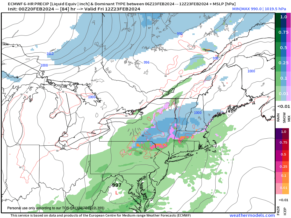
Wet Snow Possible Late Thursday Night
RE: SHOWING UP AND BEING THERE
–I show up most every day, & for every single storm
–I care about your safety and of those you love
–I try to be as accurate, helpful, and interactive as I can
–Many of you have told me you rely on me
–Now I must rely on you for support to sustain my work
SECURELY BECOME A 2024 DHTWN SUPPORTER TODAY
(Options include Cards, PayPal, Venmo, Check)
~~~~~~~~~~~~~~~~~~~~~~
TABLE OF CONTENTS
* Daily Celestials (Sun/Moon Data)
* Weekly Weather Nutshell
* Morning Discussion
* TIP: Scroll below for sections, or read all
~~~~~~~~~~~~~~~~~~~~~~
YOUR DAILY CELESTIALS
~~~~~~~~~~~~~~~~~~~~~~
STAR:
–OUR STAR ROSE AT: 6:39am this morning
–OUR STAR SETS AT: 5:28pm this evening
–TOTAL DAYLIGHT TIME: 10 hours and 49 minutes
MOON:
–OUR MOON RISES AT: 1:31pm this afternoon
–MOON RISE DIRECTION: Northeast
–OUR MOON SETS AT: 5:34am tomorrow morning
–MOON SET DIRECTION: Northwest
–MOON PHASE: Waxing Gibbous (85.5%)
~~~~~~~~~~~~~~~~~~~~~~
A NOTE FROM OUR SPONSOR
~~~~~~~~~~~~~~~~~~~~~~
Dave Hayes The Weather Nut is Sponsored by Individual Community Members, Patrons, and Tandem Bagel Company… No matter the weather, Tandem Bagel is always there for you at several valley locations to make your mornings brighter! With *New Pizza Bagels(!)*, along with bagels baked fresh daily (including Gluten-Free options), house-whipped cream cheese, coffee, and tons of lunch options, Tandem is the perfect quick stop for lunch, breakfast, or a coffee and bagel to go. Find them in Easthampton, Northampton, Hadley, Florence, and West Springfield, or use their super-streamlined online ordering tool by visiting their website.
~~~~~~~~~~~~~~~~~~~~~~
YOUR WEEKLY WEATHER NUTSHELL
~~~~~~~~~~~~~~~~~~~~~~
–Mostly sunny today as high pressure builds through the region
–Highs should reach the low to mid 30s, with some upper 30s in northern CT
–Light northwest breeze becomes variable, and then backs out of the south tonight with one last cold night in the upper teens to low 20s, dry
–High pressure pushes off of the coast tomorrow, mostly sunny skies continue, and highs come up to near 40º
–Lows will dip into the low to mid 20s, with dry conditions and a light south wind
–Thursday looks mostly sunny to start, but clouds should start to filter in late in the day
–Highs will climb into the low to mid 40s on Thursday, and a trough will be approaching from the northwest, which helps to develop a surface low that should pass just south of us or track over us
–Temps are expected to drop to near freezing Thursday night as precipitation moves into the region
–The potential exists for light accumulating wet snow in the hilltowns either side of the Valley and up into SVT/SWNH with a coating to an inch possible, with mixed rain/snow in the valley overnight
–This all changes to rain showers on Friday as a fairly weak storm moves through
–Highs Friday will rise into the low to mid 40s before a cold front swings through and drops us into the low to mid 20s for lows at night
–The weekend looks colder, especially Saturday which will be the last unseasaonably cold day we experience for many days to come
–It will be blustery and highs will only rise into the mid 20s to low 30s with lows in the teens under mostly sunny skies
–Sunday pops up by 8-10 degrees into the 35-40º range under sunny skies, with less wind
–By next week, a ridge builds in the eastern U.S. and our temps are going to soar, eventually getting into the 50s by mid week
–Fair weather dominates early week, but more rain is possible by next Wednesday as wintry conditions depart for a while
~~~~~~~~~~~~~~~~~~~~~~
YOUR MORNING DISCUSSION
~~~~~~~~~~~~~~~~~~~~~~
Good morning everybody, for winter weather detesters, your time is gonna come next week, though we do have some late-winter chill to get through before 50s arrive on our shores.
The bottom line is that we have 3 days ahead of fair weather and increasingly milder temperatures and dry conditions.
Thursday night holds the potential for some wintry precipitation, especially in the high terrain, and some light wet snow accumulations can’t be ruled out in the Berkshires, western hilltowns, SVT, SWNH and the northern Worcester highlands.
Otherwise, a showery system will be moving into the region late Thursday night into Friday before one more cold shot arrives this weekend, but at least it will be mostly sunny, even if it is blustery, especially Saturday.
After that?
The Mildening is coming.
Thanks for reading, folks, and please remember that my 10th annual 2024 Support Drive is live, so whether it’s sunny or stormy, if you depend on this community weather resource, please consider chipping in at the secure link below (options include Cards, PayPal, Venmo, or Check, thank you!)
———————————–
SECURELY BECOME A 2024 DHTWN SUPPORTER TODAY
(Options include Cards, PayPal, Venmo, Check)
~~~~~~~~~~~~~~~~~~~~~~
>>> BE KIND <<<
“Hello babies. Welcome to Earth. It’s hot in the summer and cold in the winter. It’s round and wet and crowded. On the outside, babies, you’ve got a hundred years here. There’s only one rule that I know of, babies: Goddamn it, you’ve got to be kind.”
–Kurt Vonnegut
