
POST TABLE OF CONTENTS:
–Weekly Nutshell (Quick impact list)
–Sponsor Note (Tandem Bagel Co.)
–NWS Alerts (Advisories, Warnings, Watches)
–Celestial Data (Sun/Moon info)
–Regional Summaries (quick in and out details)
–Morning Discussion (Longer-form explanation)
~~~~~~~~~~~~~~~~~~~~~~
DAVE’S WEEKLY WEATHER NUTSHELL
–Beautiful, seasonable, and increasingly breezy Thursday is on tap
–Arctic front moves through after midnight with a few snow squalls possible, especially SVT and northwest MA
–Wind shifts from southwest to northwest and gusts to 30mph by early morning
–Lows in the single digits to low teens
–Temps FALL during the day tomorrow as the Arctic empties into the WMass region
–NW winds pick up and gust 30-45mph with wind chills 10 to 20 below zero by Friday afternoon
–Friday night is the worst, with strong northwest wind gusts continuing (30 to 50mph valley to high terrain) with wind chills 20 to 40 below zero #ProtectPetsAndPipes
–Saturday morning will be dangerous cold, then we moderate into the teens during the day, continued breezy and low wind chill
–Lows single digits Saturday night, then back to unseasonably mild Sunday into the middle of next week with only a few showers possible, but before we jump into the weather discussion/details below, let’s check a note from our local and delicious sponsor, #TandemBagelCo, with their newest location in West Springfield, MA.
~~~~~~~~~~~~~~~~~~~~~~
A NOTE FROM OUR SPONSOR:
DHTWN Is Sponsored by Members, Patrons & Tandem Bagel Company: No matter the weather, Tandem Bagel is always there for you at several valley locations to make your mornings brighter! With bagels baked fresh daily (including Gluten-Free options), house-whipped cream cheese, coffee, and tons of lunch options, Tandem is the perfect quick stop for lunch, breakfast, or a coffee and bagel to go. Find them in Easthampton, Northampton, Hadley, Florence, and West Springfield, or use their super-streamlined online ordering tool by visiting their website.
~~~~~~~~~~~~~~~~~~~~~~~~~~~~~~~~
***DHTWN DAILY WEATHER REPORT***
~~~~~~~~~~~~~~~~~~~~~~~~~~~~~~~~
NATIONAL WEATHER SERVICE ALERTS
–Wind Chill Warnings have been hoisted for the entire greater WMass region from 10am Friday to 10am Saturday
DHTWN REMINDER
–The odds of being a human are 1 in 400,000 billion… do or share something you love today, even in a small way (see Kurt Vonnegut quote at end of post)
DAILY CELESTIAL (STAR):
–OUR STAR ROSE AT: 7:02am this morning
–OUR STAR WILL SET AT: 5:06pm this evening
–TOTAL DAYLIGHT TIME: 10 hours and 4 minutes
NIGHTLY CELESTIAL (MOON):
–OUR MOON WILL RISE AT: 1:59pm this afternoon
–OUR MOON WILL SET AT: 6:11am tomorrow morning
–MOON RISE DIRECTION: Northeast
–MOON SET DIRECTION: Northwest
–MOON PHASE: Waxing Gibbous (90.6%)
~~~~~~~~~~~~~~~~~~~~~~~~~~~~~~~~
DAILY TERRESTRIAL (ZoneCast)
ZONE 1 (Northern Region)
Southern VT, Southwest NH, N. Taconics NY
–High Temps: Low 30s
–Low Temps: Single digits either side of 0º
–Wind: Southwest winds gust 15-25mph today, northwest winds 20-35mph by early Friday morning
–Skies: Early clouds then Mostly sunny
–Precipitation: Isolated snow squalls around/after midnight may coat the ground and drop visibility
ZONE 2 (Central Region)
WMass, N. CMass, N. Litchfield County, C./S. Taconics NY
–High Temps: Low to Mid 30s
–Low Temps: Single digits to low 10s
–Wind: Southwest winds gust 15-25mph today, northwest winds 20-35mph by early Friday morning
–Skies: Early clouds then Mostly sunny
–Precipitation: Isolated snow squalls around/after midnight may coat the ground and drop visibility
ZONE 3 (Southern Region)
S. CMass, S. Litchfield County, NC.CT, & NE.CT
–High Temps: Mid to Upper 30s
–Low Temps: Low 10s
–Wind: Southwest winds gust 15-25mph today, northwest winds 20-35mph by early Friday morning
–Skies: Early clouds then Mostly sunny
–Precipitation: A few flurries possible late tonight
~~~~~~~~~~~~~~~~~~~~~~~~~~~~~~~~
WHERE’S DAVE?
1. I’ve been reporting our weather daily here and at https://www.westernmassweather.com for a decade
2. Get my free weekly newsletter here: https://westernmassweather.com/homepage/dhtwn-nutletter-signup/
3. Actively visit this FB page via the app or web, as I may not always auto-kiss your screens
~~~~~~~~~~~~~~~~~~~~~~~~~~~~~~~~
MORNING DISCUSSION
Good morning folks, I hope you’re gearing up for a truly brutal blast of Arctic cold air. It’ll feel like the top or bottom of the planet for about 36 hours, but fortunately it’s a quick period of super cold conditions with a fast rebound to milder temperatures by Sunday into the middle of next week.
For today, it will be lovely and seasonable with a breezy southwest wind gusting 15-25mph at times along with plenty of sunshine and highs in the low to mid 30s, with some upper 30s readings possible in northern CT.
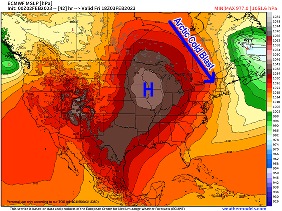
Tonight, we’ll see a powerful Arctic cold front driven through the region thanks to a massive dome of high pressure up to 1038mb dropping south-southeast into the northern Plains of the U.S.
There is nothing “downstream” (meaning, the area to where our weather is tracking) to block this incoming cold blast, so it will sweep through and lift on out, but we will all be impacted by it, and you will need to make sure you protect your pets, people and pipes during this quick blustery shiver that’ll move through every neighborhood in the region.
We may see a few snow squalls or snow showers with the frontal passage around and after midnight, especially in northwest MA and SVT where lifting will be strongest. Some coatings cannot be ruled out or even a fluffy inch in the southern Greens with briefly lowered visibilities.
Lows drop into the single digits to low 10s overnight and wind will shift from the southwest today to northwest by morning and gust 20-35mph.
As we move into Friday, it will be sunny but temps will hold steady in the single digits to mid teens and then drop later morning into the afternoon with wind gusts increasing to 30-45mph. This will produce wind chills during the day of 10 to 25 below zero from the valley to high terrain.
Friday night will be the absolute worst as record cold and chill readings are likely with lows in the single digits to 15 below zero, and wind chills down to 20 to 40 below zero as northwest winds continue to gust 30-45mph!!!
#ProtectPetsPeopleAndPipes
In addition, with wind gusts like that, a few hilltown locations may experience isolated power outages, so it’s prudent to be prepared for that potential.
Saturday morning is going to be dangerously cold, but temps will moderate and wind will slacken with time.
Don’t get me wrong, Saturday and Saturday night are still VERY cold with highs only in the teens and lows in the single digts, but that will be better than Friday and Friday night, and then by Sunday the Arctic air parcel will be long gone with highs in the 30s under mostly cloudy skies with lows in the mid 20s.
The early to mid-week period next week looks mild with highs in the upper 30s to mid 40s under mostly cloudy skies as we go back to mild and mostly cloudy, with a few rain showers by the middle of next week with no big storms in sight.
Have a great day, and I also wanted to remind you that voting for Best Of Valley Advocate closes *this evening* at 5pm, and I hope you’ll vote for me like you have over the past 8 years by clicking the link below, and then clicking on the “Information Age” section where you’ll see the “Best Local Meteorologist” category there… I’d be so grateful for your vote today!
VOTE HERE (Information Age Section).
Let’s Stay Together (click for options).
Join my Free Weekly Nutletter (click to join).
Follow me on Twitter (click to follow).
AND REMEMBER…
“Hello babies. Welcome to Earth. It’s hot in the summer and cold in the winter. It’s round and wet and crowded. On the outside, babies, you’ve got a hundred years here. There’s only one rule that I know of, babies: Goddamn it, you’ve got to be kind.”
–Kurt Vonnegut