
SECURELY BECOME A 2025 WEATHER NUT SUPPORTER TODAY
–> When 4% of readers support at any level,
this community weather resource remains active in 2025:
(Secure options include Cards, PayPal, Venmo, Check)
~~~~~~~~~~~~~~~~~~
TABLE OF CONTENTS
* Daily Celestials (Sun/Moon Data)
* Sponsor Note
* Morning Discussion
* TIP: Scroll below for sections, or read all
~~~~~~~~~~~~~~~~~~~~~~
YOUR DAILY CELESTIALS
~~~~~~~~~~~~~~~~~~~~~~
STAR:
–OUR STAR ROSE AT: 6:40am this morning
–OUR STAR SETS AT: 5:28pm this evening
–TOTAL DAYLIGHT TIME: 10 hours and 48 minutes
MOON:
–OUR MOON SETS AT: 9:28am this morning
–MOON SET DIRECTION: West-Southwest
–OUR MOON RISES AT: 12:55am tonight
–MOON RISE DIRECTION: East-Southeast
–MOON PHASE: Waning Gibbous (61.8%)
~~~~~~~~~~~~~~~~~~~~~~
A NOTE FROM OUR SPONSOR
~~~~~~~~~~~~~~~~~~~~~~
Dave Hayes The Weather Nut is Sponsored by Individual Community Members, Patrons, and Tandem Bagel Company… No matter the weather, Tandem Bagel is always there for you at several valley locations to make your mornings brighter! With *New Pizza Bagels(!)*, along with bagels baked fresh daily (including Gluten-Free options), house-whipped cream cheese, coffee, and tons of lunch options, Tandem is the perfect quick stop for lunch, breakfast, or a coffee and bagel to go.
You can either 1) visit them in Easthampton, Northampton, Hadley, Florence, and/or West Springfield, 2) hire them to cater your next event, or 3) use their super-streamlined online ordering tool by visiting their website and clicking the “Catering” or “Order Online” links.
~~~~~~~~~~~~~~~~~~~~~~
YOUR MORNING DISCUSSION
~~~~~~~~~~~~~~~~~~~~~~
Good morning folks, we’ve got great news in that with the exception of about 75 households scattered across the Commonwealth, power has been restored to Franklin County and other communities so I hope those that have been without power for upwards of 3-4 days are starting to warm up and enjoy a cup of coffee or tea.
It has been a very rough stretch this month, culminating in our weekend winter storm which brought heavy snow, tons of sleet, thick ice glazes from freezing rain, plain rain which soaked new snow packs, frigid temps which turned everything into an impossible ice brick, and powerful winds upward of 70mph in gusts that knocked out power to as many as 20,000 at its peak across the region.
Thankfully, all of that is firmly behind us, except for very cold temperatures which will continue today with highs in the upper teens to mid 20s under mostly sunny skies with northwest winds gusting 15-30mph at times.
High pressure builds into the region tonight, weakening the pressure gradient and calming the winds down, finally. Lows will drop into the single digits.
Clouds will increase Thursday into Thursday night as low pressure passes far to our south. There may be some weak interaction to help produce some scattered snow showers in the greater WMass region, but it shouldn’t amount to much of anything.
——————-
SECURELY BECOME A 2025 WEATHER NUT SUPPORTER TODAY
–> When 4% of readers support at any level,
this community weather resource remains active in 2025:
(Secure options include Cards, PayPal, Venmo, Check)
——————-
Highs will reach the mid to upper 20s with lows in the teens.
Cold air works in behind the departing storm for Friday with highs in the mid to upper 20s and northwest winds again gusting 15-30mph, with lows in the single digits.
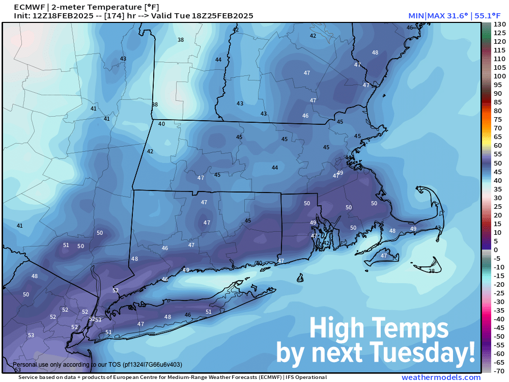
From this weekend forward, the next episode of “The Mildening” comes to a theatre near you!
This is due to high pressure passing south of us which will produce a warming southwest flow.
This will cause highs to rise from the low to mid 30s Saturday, to the mid to upper 30s Sunday, to the upper 30s to low 40s Monday, and to the upper 30s to mid 40s on Tuesday, with lows dipping into the teens over the weekend, and then the 20s by early next week.
Those temperatures represent seasonable levels, climbing to a bit above seasonable for early next week.
And the best news? Fair weather through Monday, with more sun on Saturday than Sunday.
The next chance for inclement weather will be Monday night into Tuesday with a weak Clipper system bringing light snow to rain by Tuesday.
Beyond that, we have to watch for a potential cool down by mid-week ahead of a potential winter storm for Thursday/Friday, but for now, let’s savor the wins and the improvements that are arriving, we deserve it after this wintry stretch!
Have a great day, and if you’d like to keep me in your service through 2025, you can chip in any comfortable one-time or monthly amount at the secure link to my site below:
——————-
SECURELY BECOME A 2025 WEATHER NUT SUPPORTER TODAY
–> When 4% of readers support at any level,
this community weather resource remains active in 2025:
(Secure options include Cards, PayPal, Venmo, Check)
“Follow your bliss and the universe will open doors for you where there were only walls.”
― Joseph Campbell