
SECURELY BECOME A 2025 WEATHER NUT SUPPORTER TODAY
–> When 4% of readers support at any level,
this community weather resource remains active in 2025:
(Secure options include Cards, PayPal, Venmo, Check)
~~~~~~~~~~~~~~~~~~
TABLE OF CONTENTS
* Daily Celestials (Sun/Moon Data)
* Sponsor Note
* Morning Discussion
* TIP: Scroll below for sections, or read all
~~~~~~~~~~~~~~~~~~~~~~
YOUR DAILY CELESTIALS
~~~~~~~~~~~~~~~~~~~~~~
STAR:
–OUR STAR ROSE AT: 6:41am this morning
–OUR STAR SETS AT: 5:27pm this evening
–TOTAL DAYLIGHT TIME: 10 hours and 46 minutes
MOON:
–OUR MOON SETS AT: 9:04am this morning
–MOON SET DIRECTION: West-Southwest
–OUR MOON RISES AT: 11:50pm tonight
–MOON RISE DIRECTION: East-Southeast
–MOON PHASE: Waning Gibbous (70.7%)
~~~~~~~~~~~~~~~~~~~~~~
A NOTE FROM OUR SPONSOR
~~~~~~~~~~~~~~~~~~~~~~
Dave Hayes The Weather Nut is Sponsored by Individual Community Members, Patrons, and Tandem Bagel Company… No matter the weather, Tandem Bagel is always there for you at several valley locations to make your mornings brighter! With *New Pizza Bagels(!)*, along with bagels baked fresh daily (including Gluten-Free options), house-whipped cream cheese, coffee, and tons of lunch options, Tandem is the perfect quick stop for lunch, breakfast, or a coffee and bagel to go.
You can either 1) visit them in Easthampton, Northampton, Hadley, Florence, and/or West Springfield, 2) hire them to cater your next event, or 3) use their super-streamlined online ordering tool by visiting their website and clicking the “Catering” or “Order Online” links.
~~~~~~~~~~~~~~~~~~~~~~
YOUR MORNING DISCUSSION
~~~~~~~~~~~~~~~~~~~~~~
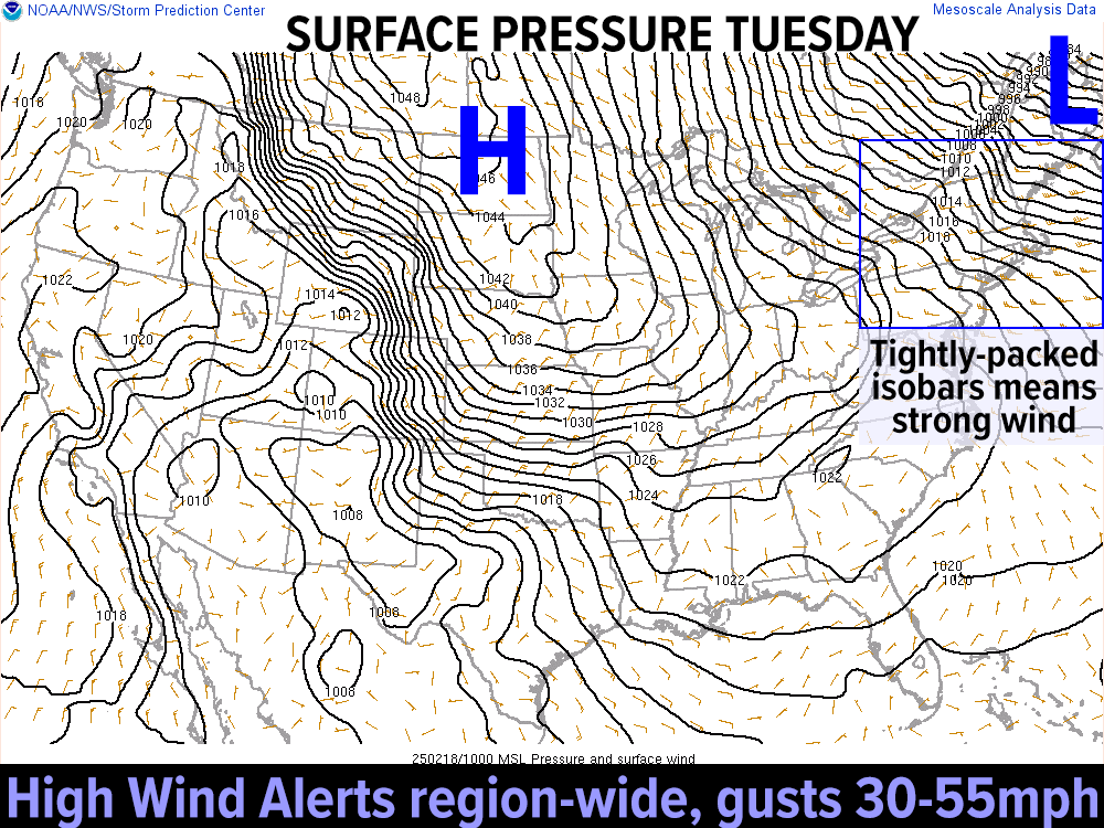
Good morning folks, the main weather headlines continue to be cold and wind as the stormy pattern we’ve been in for weeks has finally relented, with no storms of any consequence until at least the middle of next week, so that’s some good news.
The bad news is we still have over 2000 outages in Hampshire and *mostly* Franklin County, which accounts for 80% of that outage number, and some of those folks have been out for over 24 hours in this frigid air mass, NOT GOOD.
I’m sending lots of appreciation out to power restoration crews who are working in horrendous conditions with high wind in the high terrain and bitter wind chills, and those conditions will unfortunately continue to plague us today.
It shouldn’t be quite as bad, but still, westerly wind gusts of 30-55mph will not speed up restoration efforts, let’s put it that way.
To folks still without power and somehow getting this report, please hang in there best you can, because there IS light on the horizon: after one more day/night of cold and wind, the wind comes down on Wednesday (though still a bit breezy), and there are no other storms in sight until well into next week, so improvements are coming.
For today, highs will only reach the upper teens to low 20s, and with wind gusts of 30-55mph, wind chills will be down near 0º at times under partly sunny skies.
——————-
SECURELY BECOME A 2025 WEATHER NUT SUPPORTER TODAY
–> When 4% of readers support at any level,
this community weather resource remains active in 2025:
(Secure options include Cards, PayPal, Venmo, Check)
——————-
We’ll see one more lake effect snow shower band try to push into the Berkshires and/or northwest CT, so some new coatings are possible there.
Lows tonight will drop into the single digits and continued wind gusts of 25-40mph, wind chills will drop below zero again, though not like the -17º reading we saw in SVT this morning.
For Wednesday, our Atlantic Canadian low pulls further away, and that will help weaken the pressure gradient, though gusts will still come up to the 20-30mph range at times under mostly sunny skies, with lows in the single digits under partly cloudy skies.
By Thursday, a coastal storm will likely graze Cape Cod with light accumulating snowfall but should only result in a few snow showers for us here in the greater WMass region with mostly cloudy skies and highs in the mid to upper 20s and lows in the low to mid teens.
Friday through Monday represents a period of fair weather, moderating temperatures, breezy at times, but overall vast improvements weather-wise compared to what we’ve been going through, and still need to muddle through over the next couple of days.
Hang in there folks, have a great day, and if you’d like to keep me in your service through 2025, you can chip in any comfortable one-time or monthly amount at the secure link to my site below:
——————-
SECURELY BECOME A 2025 WEATHER NUT SUPPORTER TODAY
–> When 4% of readers support at any level,
this community weather resource remains active in 2025:
(Secure options include Cards, PayPal, Venmo, Check)
“Follow your bliss and the universe will open doors for you where there were only walls.”
― Joseph Campbell