
Good morning everybody, to start I’ve been getting numerous questions about the impacts in our region about the train derailment in East Palestine, OH.
I did smell a strange chemical smell yesterday before the cold front came through, but once it did, that smell was gone. I honestly have no idea what this means in terms of air quality, drinking water, our health, our pet’s/animal’s health, etc. as this is not within my zone of competence.
I would encourage you to contact the people in charge of monitoring air quality with your concerns, which is the Massachusetts Department of Environmental Protection.
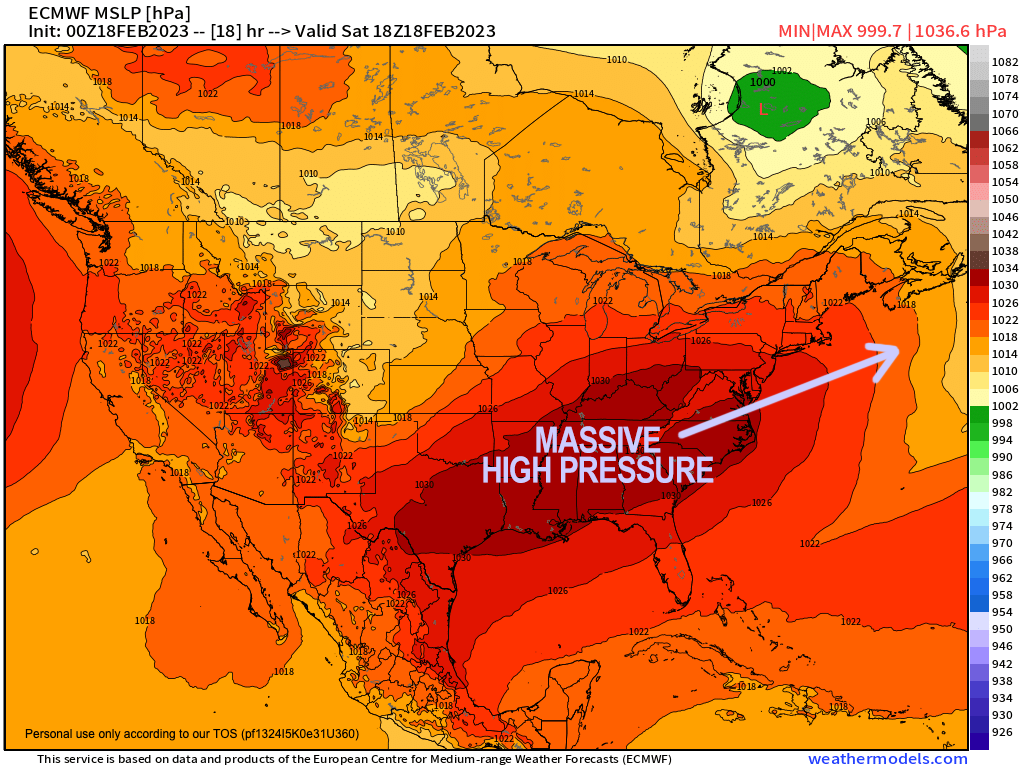
As for our weather, we have a lovely day ahead with plenty of sunshine thanks to a massive high pressure system that is spread across the eastern half of the country and will be passing to our south through the weekend.
This high has mostly slackened our winds from early this morning and overnight, and will produce seasonably cold temperatures with highs in the mid 30s to low 40s across the region.
For tonight, a combo of high clouds and a bit of a developing southwest breeze should allow temps to stay above 20º for most areas, likely in the low to mid 20s region-wide under partly cloudy skies.
For Sunday, high pressure moves south and east of New England and with clockwise flow will direct southerly flow into the region, and cause winds to gust up over 20mph at times.
————————————–
WHAT WILL I GET WHEN I JOIN
DHTWN’s SUPPORT NUTWORK TODAY?
–> NO HYPE: You’ll get an independent weather man who serves no overlords and refrains from hype, fear mongering and sensationalism.
–> Click this secure link to select from many support options, thanks!
——————-
This flow will also warm our temps up into the 40s for highs, but also cause mostly cloudy skies to develop with a few sunny breaks possible, especially in the morning.
By the nighttime, clouds will thicken even further with lows in the low to mid 30s.
On Monday, a weaker system will be passing to our north which will drag a weak cold front into the region, and spark some scattered showers by afternoon with highs in the mid 40s to low 50s.
However, it’s possible that in the warm advection flow ahead of the front, some areas like northeast CT into southern CMass may see a few morning showers as well, while we stay drier further west until mid-day.
It’ll be breezy Monday night with colder air working back into the region with a flurry or shower possible, and lows in the 20s.
A second and more robust system again tracks north of us on Tuesday, but should have more energy with it, and will bring a period of rain showers, mixed with snow across southern VT and southwest NH, and possibly some northern parts of the WMass region, quitting at night.
Highs will be in the upper 30s to mid 40s with lows in the upper 20s.
Then we approach the Wednesday/Thursday timeframe, which will be more interesting in terms of the potential for winter weather.
A huge sprawling high pressure system will be spreading east into southern Canada, while an upper level system moves into the eastern part of the country, and sets up a temperature gradient in the north-central and northeast U.S.
Clouds will be increasing, and highs should be well above freezing on Wednesday with some showers by afternoon.
However, by Wednesday night into Thursday, a period of snow, ice and rain (more wintry north, less wintry south) will set up and could cause travel impacts for the morning commute, so stay tuned for updates.
In addition, another system that looks even colder for that weekend could bring some snow to the region, so suffice it to say, there are 4 systems over the next week that I will be watching and updating you on.
Have a great day, and remember…
PLANTS THAT WE WATER KEEP FLOWERING:
When 4% (1 in 25) of my readers “water” my work with even $5 or 10/year, $2/month (or more if you’re able) I can remain in your service.
—-> A major storm likely put me on your radar in the past
—-> Despite a mild Winter, this is New England
—-> Whether our weather’s Mild or Wild, it will eventually turn
—-> When it does, I want to show up for you and yours
That’s why I’m asking you to join my 2023 Support Network today as a Member or as a Supporter by clicking the secure link above, before my Member Drive ends 3/26/23.
Thank you!!