
SECURELY BECOME A 2025
WEATHER NUT SUPPORTER TODAY
–> When 4% of readers support at any level,
this community weather resource remains active in 2025:
(Secure options include Cards, PayPal, Venmo, Check)
~~~~~~~~~~~~~~~~~~
TABLE OF CONTENTS
* Daily Celestials (Sun/Moon Data)
* Sponsor Note
* Morning Discussion
* TIP: Scroll below for sections, or read all
~~~~~~~~~~~~~~~~~~~~~~
YOUR DAILY CELESTIALS
~~~~~~~~~~~~~~~~~~~~~~
STAR:
–OUR STAR ROSE AT: 6:43am this morning
–OUR STAR SETS AT: 5:25pm this evening
–TOTAL DAYLIGHT TIME: 10 hours and 42 minutes
MOON:
–OUR MOON RISES AT: 10:46pm tonight
–MOON RISE DIRECTION: East-Southeast
–OUR MOON SETS AT: 9:04am tomorrow morning
–MOON SET DIRECTION: West-Southwest
–MOON PHASE: Waning Gibbous (78.9%)
~~~~~~~~~~~~~~~~~~~~~~
A NOTE FROM OUR SPONSOR
~~~~~~~~~~~~~~~~~~~~~~
Dave Hayes The Weather Nut is Sponsored by Individual Community Members, Patrons, and Tandem Bagel Company… No matter the weather, Tandem Bagel is always there for you at several valley locations to make your mornings brighter! With *New Pizza Bagels(!)*, along with bagels baked fresh daily (including Gluten-Free options), house-whipped cream cheese, coffee, and tons of lunch options, Tandem is the perfect quick stop for lunch, breakfast, or a coffee and bagel to go.
You can either 1) visit them in Easthampton, Northampton, Hadley, Florence, and/or West Springfield, 2) hire them to cater your next event, or 3) use their super-streamlined online ordering tool by visiting their website and clicking the “Catering” or “Order Online” links.
~~~~~~~~~~~~~~~~~~~~~~
YOUR MORNING DISCUSSION
~~~~~~~~~~~~~~~~~~~~~~
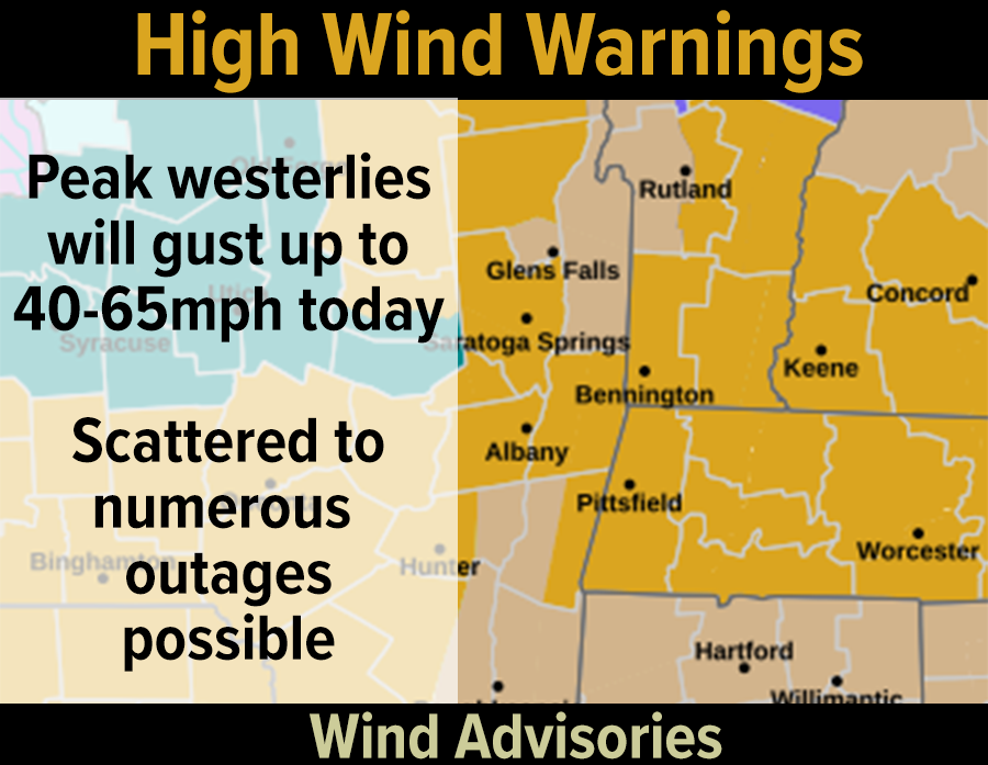
Good morning folks, we’ve had peak winds overnight up to 55mph that have produced 5600 outages in WMass/CMass, 3500 outages in northern CT and over 1000 outages in SVT with just a few in southwest NH.
I want to send deep thanks out to all of the power restoration crews, as I expect these outage numbers will climb today, and possibly substantially as westerlies should reach speeds of 40-65mph at times, with those highest gusts on east-facing slopes of the Berkshires, Litchfield Hills, western hilltowns, southern Greens in VT and the northern Worcester hills.
Air can speed up as it downslopes (i.e. rides up and over and down mountain tops) as air races from high pressure over the Midwest into and around our powerhouse cyclone now over Nova Scotia which threw the meteorological kitchen sink at us Saturday night through last night.
This downsloping is why east-facing slopes may see the worst of the wind today.
In addition, we’ve got additional snow accumulations already underway due to lake effect snow bands that are flying some flakes in the Pioneer Valley, but are more impactfully adding additional coatings up to 2” or 3” in the Berkshires, northwest hilltowns, and other nearby areas out that way.
In fact, I still expect that given the strength of the wind today, and with the right angle being achieved, we’ll see a multi-Great-Lakes snow band form all the way from Lake Superior through Lakes Huron and Ontario and into WMass and CMass this afternoon!
Highs today will reach the upper teens to mid 20s under partly sunny skies on average (more clouds over the high terrain) with wind chills in the single digits and down near 0º at times.
~~~~~~~~~~~~~~~~~~
SECURELY BECOME A 2025
WEATHER NUT SUPPORTER TODAY
–> When 4% of readers support at any level,
this community weather resource remains active in 2025:
(Secure options include Cards, PayPal, Venmo, Check)
~~~~~~~~~~~~~~~~~~
Lows tonight will dip into the single digits and westerly wind gusting 30-45mph overnight into Tuesday, wind chills will go below zero, and well below zero in SVT where Cold Weather Advisories have been hoisted for wind chills of -15 to -25º below zero!
For Tuesday, a very cold morning is in store, and it will still be gusty during the day with speeds of 30-45mph still being achieved, making it harder for power restoration crews to do their jobs.
Highs will only reach the upper teens to low 20s under partly sunny skies with lows again in the single digits as the wind starts to subside with high pressure moving in for mid-week.
Wednesday looks similar to Tuesday with highs in the upper teens to mid 20s, but it will feature more sunshine and less wind, so that’s good! Lows again will drop into het single digits as peak winter settles over the region.
By Thursday, I will be monitoring a potential coastal snowstorm, but as I have been saying for days now, it more likely than not stays south and out to sea, with potential for some light snow or snow showers here in the greater WMass region. Highs will climb into the 20s with lows in the low teens.
Friday through Sunday looks like fair weather for a change! In addition, temps will be coming up toward more seasonable levels (though still below average) with highs in the mid 20s to mid 30s and lows in the teens.
Have a great day, watch for flying icy bits or branches, and if you’d like to keep me in your service through 2025 you can chip in any comfortable one-time or monthly amount at the secure link to my site below:
~~~~~~~~~~~~~~~~~~
SECURELY BECOME A 2025
WEATHER NUT SUPPORTER TODAY
–> When 4% of readers support at any level,
this community weather resource remains active in 2025:
(Secure options include Cards, PayPal, Venmo, Check)
~~~~~~~~~~~~~~~~~~
“Follow your bliss and the universe will open doors for you where there were only walls.”
― Joseph Campbell