
TABLE OF CONTENTS:
–Weekly Nutshell (Quick impact list)
–Sponsor Note (Tandem Bagel Co.)
–NWS Alerts (Advisories, Warnings, Watches)
–Celestial Data (Sun/Moon info)
–Regional Summaries (quick in and out details)
–Morning Discussion (Longer-form explanation)
~~~~~~~~~~~~~~~~~~~~~~
DAVE’S WEEKLY WEATHER NUTSHELL
–Very mild start to the day, with highs in mid 50s to low 60s valley points east, highs upper 40s to low 50s north and west
–We have some scattered showers and thunderstorms racing east-northeast into eastern NY as of this writing
–Should these hold, some brief thunder possible (best chance Pittsfield north in the Berkshires and SVT)
–Main area of showers moves in for late morning into early/mid-afternoon with cold front
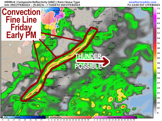
–Fine convection line could bring an early/mid afternoon downpours with gusty winds either side of that line, up to 35-40mph in the valley and up to 50mph in the hills possible
–Showers are gone by mid-afternoon with some partial clearing late, nice sunset possible!
–Cold air advection commences, with northwest winds gusting 25-40mph into the evening, and temps crash into the teens
–Wind chills should dip into the single digits
–Saturday is the weekend pick, with highs in the mid to upper 30s, westerly breeze, sunny, lows 20s
–Sunday clouds up and mildens up with highs in the 40s
–Sunday night through Tuesday night sees a couple of frontal passages, cold front Monday, warm front Tuesday night
–Both bring a chance for showers, but it’s mostly just mostly cloudy and fairly mild
–Mid to late week is still murky, but chance for wintry weather cannot be ruled out yet, especially by late week, but before we jump into the weather discussion/details below, let’s check a note from our local and delicious sponsor, #TandemBagelCo, with their newest location in West Springfield, MA.
~~~~~~~~~~~~~~~~~~~~~~
A NOTE FROM OUR SPONSOR:
Dave Hayes The Weather Nut is Sponsored by Members, Patrons & Tandem Bagel Company… No matter the weather, Tandem Bagel is always there for you at several valley locations to make your mornings brighter! With bagels baked fresh daily (including Gluten-Free options), house-whipped cream cheese, coffee, and tons of lunch options, Tandem is the perfect quick stop for lunch, breakfast, or a coffee and bagel to go. Find them in Easthampton, Northampton, Hadley, Florence, and West Springfield, or use their super-streamlined online ordering tool by visiting their website.
~~~~~~~~~~~~~~~~~~~~~~~~~~~~~~~~
***DHTWN DAILY WEATHER REPORT***
~~~~~~~~~~~~~~~~~~~~~~~~~~~~~~~~
NATIONAL WEATHER SERVICE ALERTS
–None.
DHTWN REMINDER
–It doesn’t take much to do a nice thing for somebody that you don’t know.
DAILY CELESTIAL (STAR):
–OUR STAR ROSE AT: 6:43am this morning
–OUR STAR WILL SET AT: 5:25pm this evening
–TOTAL DAYLIGHT TIME: 10 hours and 41 minutes
NIGHTLY CELESTIAL (MOON):
–OUR MOON WILL SET AT: 1:57pm this morning
–OUR MOON WILL RISE AT: 6:03am tomorrow morning
–MOON SET DIRECTION: Southwest
–MOON RISE DIRECTION: Southeast
–MOON PHASE: Waning Crescent (11.7%)
~~~~~~~~~~~~~~~~~~~~~~~~~~~~~~~~
DAILY TERRESTRIAL
ZONE 1 – Northern Region
(Southern VT, Southwest NH)
–High Temps (Today): Upper 40s to Mid 50s
–Low Temps (Tonight): Mid Teens
–High Temps (Tomorrow): Mid to Upper 30s
–Winds: Lighter early, then by mid-day southerly winds could gust 25-40mph, then veer to northwest 25-40mph, possibly higher with frontal passage
–Chill: Near zero wind chills possible, single digits
–Sky Cover: Mostly cloudy, some partial sunshine by end of day
–Precipitation: Thunderstorms and showers early this morning possible, then more showers and a downpour possible from late morning to early/mid afternoon, drying tonight
ZONE 2 – Central Region
(Western MA, North-Central MA, Northern Litchfield CT)
–High Temps (Today): Mid to Upper 50s, some low 50s Berks
–Low Temps (Tonight): Mid to Upper Teens
–High Temps (Tomorrow): Mid 30s to Low 40s
–Winds: Lighter early, then by mid-day southerly winds could gust 25-40mph, then veer to northwest 25-40mph, possibly higher with frontal passage in the high terrain
–Chill: Near zero wind chills possible high terrain, single digits to low teens elsewhere
–Sky Cover: Mostly cloudy, some partial sunshine by end of day
–Precipitation: Thunderstorms and showers early this morning in the Berkshires and western Franklin County, then more showers and a downpour possible from late morning to early/mid afternoon, drying tonight
ZONE 3 – Southern Region
(South-Central MA, Northern CT)
–High Temps (Today): Upper 50s to Low 60s
–Low Temps (Tonight): Upper Teens to Low 20s
–High Temps (Tomorrow): Upper 30s to Low 40s
–Winds: Lighter early, then by mid-day southerly winds could gust 25-40mph, then veer to northwest 25-40mph, possibly higher with frontal passage
–Sky Cover: Mostly cloudy, some partial sunshine by end of day
–Precipitation: Showers early this morning possible, then more showers and a downpour possible from late morning to early/mid afternoon, drying tonight
~~~~~~~~~~~~~~~~~~~~~~~~~~~~~~~~
MORNING DISCUSSION
Good morning everybody, we’ve got some thunder on the way for areas of northwest MA into southern VT, and a few scattered showers possible elsewhere before the main batch of showers with the cold front works into the region by late morning into mid afternoon.
A storm will be tracking northeast into northern New England today and slide its cold front through the region. Before it does so, our unusually mild temps in this morning in the upper 30s to low 50s will be encouraged to rise into the upper 40s to low 60s from northwest to southeast across the greater WMass region with strong southwest flow.
The main area of showers with the front moves in late morning into early/mid afternoon during a time when we could see southwest winds gusting 25-40mph just before the front passes and also associated with a fine line of convection which could produce another rumble of thunder and/or a brief period of downpours, which will enhance wind gusts potentially.
Behind this front, wind veers out of the northwest, and we could also see a burst of wind at that time up to 40 or 45mph before cold advection settles in and winds gust more like 25-35mph into the evening.
Temps will decrease and skies will break up, hopefully revealing a nice sunset!!
It will be a blustery and cold night with lows in the teens to low 20s, and wind chills will be mostly in the single digits as cold air settles in.
But, as with all of our cold shots this year, there is no blocking pattern upstream to keep the cold in place, so even though seasonably cold highs in the mid 30s to low 40s arrive tomorrow under sunny skies (with lows in the 20s), clouds build Sunday with milder temps well into the 40s, and with a few showers possible late Sunday night.
We’ll see two disturbances move through in zonal flow early to mid next week with a few showers Monday, and again Tuesday evening/night with temps well into the 40s under mostly cloudy skies through this period.
The late week timeframe is still up in the air (get it, UP IN THE AIR, I’ll be here all week, and hopefully all year), and the potential still exists for wintry weather. However, we have to err on the side of mildness given this Winter and assume for now that any storms would be rainy, but I will keep you updated!
Have a great day!
Let’s Stay Together (click for options).
Join my Free Weekly Nutletter (click to join).
Follow me on Twitter (click to follow).
AND REMEMBER…
“Hello babies. Welcome to Earth. It’s hot in the summer and cold in the winter. It’s round and wet and crowded. On the outside, babies, you’ve got a hundred years here. There’s only one rule that I know of, babies: Goddamn it, you’ve got to be kind.”
–Kurt Vonnegut