
SECURELY BECOME A 2025
WEATHER NUT SUPPORTER TODAY
–> When 4% of readers support at any level,
this community weather resource remains active in 2025
(Secure options include Cards, PayPal, Venmo, Check)
~~~~~~~~~~~~~~~~~~
TABLE OF CONTENTS
* Daily Celestials (Sun/Moon Data)
* Sponsor Note
* Morning Discussion
* TIP: Scroll below for sections, or read all
~~~~~~~~~~~~~~~~~~~~~~
YOUR DAILY CELESTIALS
~~~~~~~~~~~~~~~~~~~~~~
STAR:
–OUR STAR ROSE AT: 6:47am this morning
–OUR STAR SETS AT: 5:22pm this evening
–TOTAL DAYLIGHT TIME: 10 hours and 35 minutes
MOON:
–OUR MOON RISES AT: 7:40pm this afternoon
–MOON RISE DIRECTION: East
–OUR MOON SETS AT: 8:06am tomorrow morning
–MOON SET DIRECTION: West
–MOON PHASE: Waning Gibbous (96.4%)
~~~~~~~~~~~~~~~~~~~~~~
A NOTE FROM OUR SPONSOR
~~~~~~~~~~~~~~~~~~~~~~
Dave Hayes The Weather Nut is Sponsored by Individual Community Members, Patrons, and Tandem Bagel Company… No matter the weather, Tandem Bagel is always there for you at several valley locations to make your mornings brighter! With *New Pizza Bagels(!)*, along with bagels baked fresh daily (including Gluten-Free options), house-whipped cream cheese, coffee, and tons of lunch options, Tandem is the perfect quick stop for lunch, breakfast, or a coffee and bagel to go.
You can either 1) visit them in Easthampton, Northampton, Hadley, Florence, and/or West Springfield, 2) hire them to cater your next event, or 3) use their super-streamlined online ordering tool by visiting their website and clicking the “Catering” or “Order Online” links.
~~~~~~~~~~~~~~~~~~~~~~
YOUR MORNING DISCUSSION
~~~~~~~~~~~~~~~~~~~~~~
Good morning folks, now THAT was a windy night!! I saw a peak wind gust of 54mph at Worcester MA airport, and I know there numerous 40-50mph gusts in our region that produced about 200 outages in CMass as of this writing.
Wind will continue this morning into afternoon with gusts again of 30-50mph, but as the low level jet streak pulls east of us, wind will come down later this afternoon as Nova Scotian low tracks and high pressure pushes from the center of the country east towards New England.
Highs today will reach the mid 20s to low 30s under mostly sunny skies, expect more clouds over the Berkshires due to ongoing lake effect snow showers and flurries due to northwest flow off of Lake Ontario this morning.
For tonight, winds will become light after midnight with lows in the single digits into the teens under partly cloudy skies.
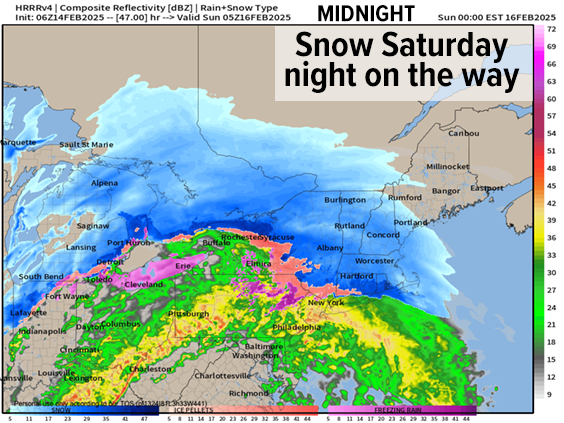
For Saturday, we will be clouding up as the morning proceeds into the afternoon, with highs climbing only into the upper 20s to low 30s.
Low pressure will be pushing east-northeast toward the Ohio Valley and PA as it extends its warm front east towards New England, along which a shield of precipitation will be forming and heading towards the greater WMass region.
I expect during the 3-9pm timeframe, roughly, that we’ll see periods of snow or snow showers before the snow shield really thickens up sometime either side of the 9pm hour when show will fall more moderately to perhaps briefly heavy at times toward and after midnight. Lows will dip into the low to mid 20s.
——————-
SECURELY BECOME A 2025 SUPPORTER TODAY
(Secure options include Cards, PayPal, Venmo, Check)
——————-
Unfortunately, there is still uncertainty at this range in terms of changeover to ice timeframes on Sunday, and where in our region that happens, because I’m unsure where the anticipated secondary low pressure system forms, how it tracks and how strong it becomes as it deepens somewhere in the Gulf of Maine by Sunday late afternoon to night.
While some parts of southern VT and southwest NH may stay all snow or mostly snow with some sleet, I think most of us will change to sleet and/or freezing rain by Sunday morning, and certainly by Sunday mid-day when the mildest surge of air at all levels reaches our region.
With highs expected to reach the 30s on Sunday toward mid-day, I believe we will see plain rain form in the valley from Springfield metro south into the Hartford region and points east, but as the secondary low starts to develop somewhere in southern New England or just south of it during the mid afternoon, colder air will start to be pulled south and east at all levels, possibly as soon as late afternoon, but more likely in the early evening.
This would re-initiate concern of a change back to icing where plain rain formed, and also change areas along and north of Route 2 in far northern MA up into SVT and SWNH back to sleet and snow before the storms ends Sunday night.
Again, for now, I am sticking with snow/sleet totals of 2-5” across WMass, CMass and northern CT south of the Route 2 corridor, with 5-10” north of Rt 2 in northern MA up into SVT and SWNH, though we could see 5-10” in western Hampshire/Franklin Counties and the central and northern Berkshires as well.
This is the type of storm setup that could produce a wide variety of totals from 2” in northern CT to over a foot in SVT, so I will do my best to stay on top of all of the details.
Sunday night into Monday will see a cold front sweep the region with strong winds developing into Monday, when scattered outages will be possible as Arctic air moves in.
Monday through Wednesday are cold, with highs in the teens to low 20s and lows in the single digits, and I will be watching for potential of a coastal snowstorm Thursday evening, but for now, I am focused on this incoming, complex winter storm for this weekend.
Have a great day, and if you’d like to keep me in your service, you can chip in any comfortable one-time or monthly amount at the secure link to my site below:
——————-
SECURELY BECOME A 2025 SUPPORTER TODAY
–> When 4% of readers support at any level,
this community weather resource can continue in 2025
(Secure options include Cards, PayPal, Venmo, Check)
“Follow your bliss and the universe will open doors for you where there were only walls.”
― Joseph Campbell