
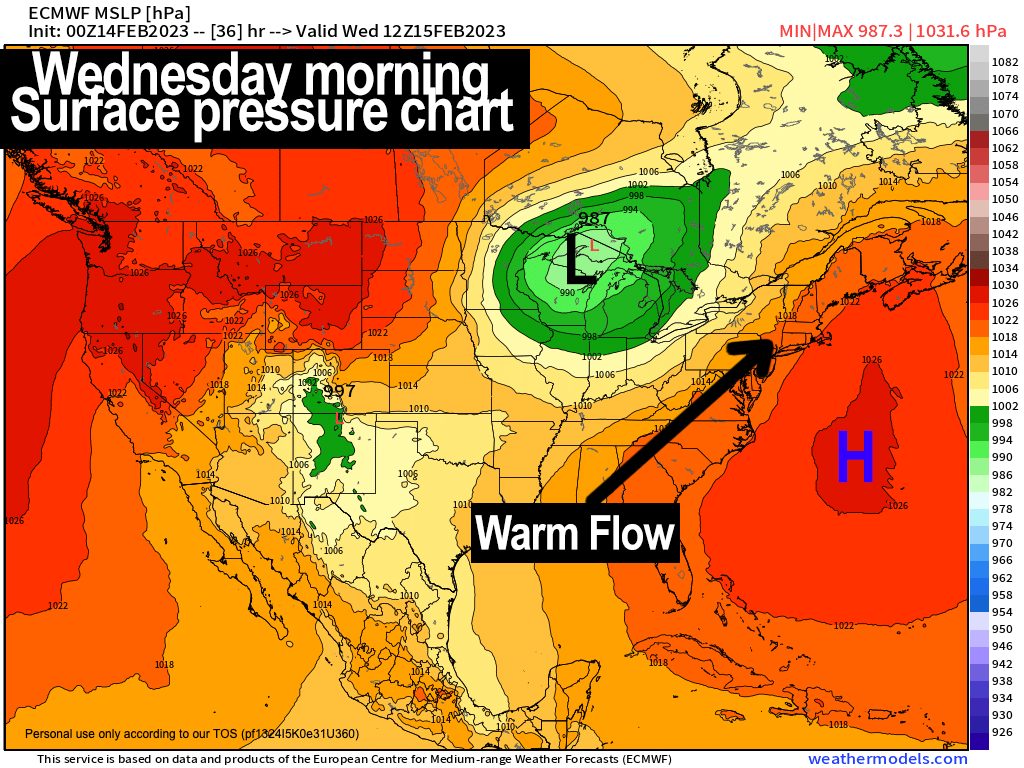
Milder Wednesday flow.
–Weekly Nutshell (Quick impact list)
–Sponsor Note (Tandem Bagel Co.)
–NWS Alerts (Advisories, Warnings, Watches)
–Celestial Data (Sun/Moon info)
–Regional Summaries (quick in and out details)
–Morning Discussion (Longer-form explanation)
~~~~~~~~~~~~~~~~~~~~~~
DAVE’S WEEKLY WEATHER NUTSHELL
–Early clouds give way to increasing sunshine, highs 40s
–Northwest to west winds gust 20-30mph this morning, then slacken into the afternoon/evening to light
–Clouds build tonight with southerly flow developing
–Partly sunny Wednesday with milder highs in the 50s and southerly gusts up to 35mph, and breezy at night, dry
–Clouds build Thursday with temps soaring well into the 50s to low 60s
–Wind gusts may reach 40mph into Thursday night in strong warm advection along with periods of showers at night into Friday
–Rain quits either side of noon with strong cold front moving through Friday afternoon with sharply dropping temps and blustery winds, with lows in the teens
–Seasonably cold and sunny Saturday in the 30s, milder and sunny Sunday in the 40s
–Early next week looks milder with another shot at rising into the 50s with colder signals to end the week, but before we jump into the weather discussion/details below, let’s check a note from our local and delicious sponsor, #TandemBagelCo, with their newest location in West Springfield, MA.
~~~~~~~~~~~~~~~~~~~~~~
A NOTE FROM OUR SPONSOR:
Dave Hayes The Weather Nut is Sponsored by Members, Patrons & Tandem Bagel Company… No matter the weather, Tandem Bagel is always there for you at several valley locations to make your mornings brighter! With bagels baked fresh daily (including Gluten-Free options), house-whipped cream cheese, coffee, and tons of lunch options, Tandem is the perfect quick stop for lunch, breakfast, or a coffee and bagel to go. Find them in Easthampton, Northampton, Hadley, Florence, and West Springfield, or use their super-streamlined online ordering tool by visiting their website.
~~~~~~~~~~~~~~~~~~~~~~~~~~~~~~~~
***DHTWN DAILY WEATHER REPORT***
~~~~~~~~~~~~~~~~~~~~~~~~~~~~~~~~
NATIONAL WEATHER SERVICE ALERTS
–D’zero, as Mr. Hennessey used to say in high school English class.
DHTWN REMINDER
–The odds of being a human are 1 in 400,000 billion, so do or share something you love today, even in a small way (see Kurt Vonnegut quote at end of post)
DAILY CELESTIAL (STAR):
–OUR STAR ROSE AT: 6:48am this morning
–OUR STAR WILL SET AT: 5:21pm this evening
–TOTAL DAYLIGHT TIME: 10 hours and 33 minutes
NIGHTLY CELESTIAL (MOON):
–OUR MOON WILL SET AT: 10:59am this morning
–OUR MOON WILL RISE AT: 3:00am tomorrow morning
–MOON SET DIRECTION: West-Southwest
–MOON RISE DIRECTION: East-Southeast
–MOON PHASE: Waning Crescent (41.4%)
~~~~~~~~~~~~~~~~~~~~~~~~~~~~~~~~
DAILY TERRESTRIAL (ZoneCast)
ZONE 1 (Northern Region)
Southern VT, Southwest NH, N. Taconics NY
–High Temps: Low to Mid 40s
–Low Temps: Upper 20s to Low 30s
–Wind: Northwest winds gust 20-35mph, then slacken later
–Skies: Mostly sunny skies developing
–Precipitation: None
ZONE 2 (Central Region)
WMass, N. CMass, N. Litchfield County, C./S. Taconics NY
–High Temps: Mid to Upper 40s
–Low Temps: Upper 20s to Low 30s
–Wind: Northwest winds gust 20-35mph, then slacken later
–Skies: Mostly sunny skies developing
–Precipitation: None
ZONE 3 (Southern Region)
S. CMass, S. Litchfield County, NC.CT, & NE.CT
–High Temps: Mid to Upper 40s
–Low Temps: Low 30s
–Wind: Northwest winds gust 15-25mph, then slacken later
–Skies: Mostly sunny skies developing
–Precipitation: None
~~~~~~~~~~~~~~~~~~~~~~~~~~~~~~~~
MORNING DISCUSSION
Good morning folks, Happy Valentine’s Day to you! Question: did you see any snow coatings overnight? I imagine those that did are in the higher elevations, but let me know, thanks!
As for our weather today, we’re watching a cold front slide off of the coastline with final showers for coastal areas as drier moves back into the region.
Increasing high pressure up and down the eastern seaboard is responsible for this incoming influx of dryness, and given the pressure gradient between our departing low and incoming high, northwest to west winds will continue to gust 20-35mph at times this morning and then lighten by afternoon and evening.
Highs will rise firmly into the 40s under increasing sunshine, and lows should drop into the upper 20s to low 30s with clouds building late as southerly mild advection commences.
Wednesday looks like a milder, gusty day with southerly winds blowing 25-35mph at times as temps surge into the 50s for highs under partly sunny skies. Lows will be mild, hanging in the low 40s with continued breezy conditions as clouds build late.
By Thursday, a storm system will be tracking northeast into the Great Lakes and will be passing well north of us, as is the story for much of this winter season.
Clouds will increase to overcast, and southwest winds may gust 25-40mph into the night as showers move in by afternoon into the evening.
It will be very mild and some high temp records may fall on that day with highs well into the 50s to low 60s.
Scattered showers continue, and temps will remain mild at night (in the 40s) with strong southwest flow between strengthening low pressure to our north and high pressure to our southeast.
For Friday, morning showers will taper off by early afternoon, and a cold front will swing through the region. Before that happens, highs are expected to reach the upper 40s to mid 50s before falling sharply as cold air advection begins.
We may get a nice sunset opportunity if clouds break up near sunset, so tuck that into your pre-frontal cortex for future recall.
Temps plunge down into the teens Friday night, and it will be blustery as well.
Saturday looks lovely and seasonably cold with highs in the low to mid 30s under sunny skies with northwest breezes, and lows in the 20s.
Milder air works back into the region Sunday into early next week with more showers by mid-week, and we can’t totally rule out wintry precipitation at this point.
I will keep an eye on things and watch the trends to see if a colder signal continues to flex itself in the guidance for the second half of next week.
Have a great day!
Let’s Stay Together (click for options).
Join my Free Weekly Nutletter (click to join).
Follow me on Twitter (click to follow).
AND REMEMBER…
“Hello babies. Welcome to Earth. It’s hot in the summer and cold in the winter. It’s round and wet and crowded. On the outside, babies, you’ve got a hundred years here. There’s only one rule that I know of, babies: Goddamn it, you’ve got to be kind.”
–Kurt Vonnegut